The Hollingwood Common Canal (alternatively the Hollingwood Common Canal Tunnel or the Hollingwood Common Tunnel) is a disused navigable coal mine adit which terminated at the Chesterfield Canal at Hollingwood, near Staveley, Derbyshire.
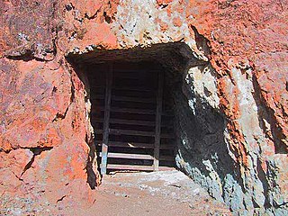
The Hollingwood Common canal tunnel was 1.75 miles (2.82 km) long, and measured six feet (1.8 m) high, five feet nine inches (1.75 m) with two feet (0.61 m) of water. Its water level was one foot (0.30 m) lower than that of the Chesterfield canal, requiring the trans-shipment of coal at a wharf constructed at the terminus. [1] The water level in the tunnel was maintained lower than the canal by a culvert that ran beneath the canal. [2] The wharf was on the old line of the Chesterfield Canal, prior to the 1892 cut being constructed. The entrance to the tunnel is still visible, though is gated off. [3]
Boats used were loaded underground within the coal mine the tunnel served; these boats were twenty-one feet (6.4 m) long and three feet six inches (1.07 m) wide, and held seven cones or boxes containing twenty to twenty two hundredweight of coal each. [4]
The wharf where the coal was transhipped was destroyed in the 1890s, when a new route for the Chesterfield Canal was built, passing to the south of Staveley Works. The original route was then filled in. Cinderhill Lock on the old route was replaced by Hollingwood Lock on the new. [3] [5] After the Chesterfield Canal Trust published an article about finding part of the tunnel, it was investigated by the Coal Authority, which is responsible for making sure that remains connected with coal mining are safe. They lowered the water level in the tunnel by 1.3 feet (400 mm) to expose more of the brickwork, and then made it good, before fitting a metal grille across the entrance. [3]
Staveley is a former mining town in the borough of Chesterfield, Derbyshire, England, alongside the River Rother, between Eckington to the north, Barlborough to the east, Sutton cum Duckmanton to the south and Brimington to the west.

The Herefordshire and Gloucestershire Canal is a canal in the west of England, which ran from Hereford to Gloucester, where it linked to the River Severn. It was opened in two phases in 1798 and 1845, and closed in 1881, when the southern section was used for the course of the Ledbury and Gloucester Railway. It is the subject of an active restoration scheme.

The Manchester Bolton & Bury Canal is a disused canal in Greater Manchester, England, built to link Bolton and Bury with Manchester. The canal, when fully opened, was 15 miles 1 furlong (24 km) long. It was accessed via a junction with the River Irwell in Salford. Seventeen locks were required to climb to the summit as it passed through Pendleton, heading northwest to Prestolee before it split northwest to Bolton and northeast to Bury. Between Bolton and Bury the canal was level and required no locks. Six aqueducts were built to allow the canal to cross the rivers Irwell and Tonge and several minor roads.

The Chesterfield Canal is a narrow canal in the East Midlands of England and it is known locally as 'Cuckoo Dyke'. It was one of the last of the canals designed by James Brindley, who died while it was being constructed. It was opened in 1777 and ran for 46 miles (74 km) from the River Trent at West Stockwith, Nottinghamshire to Chesterfield, Derbyshire, passing through the Norwood Tunnel at Kiveton Park, at the time one of the longest tunnels on the British canal system. The canal was built to export coal, limestone, and lead from Derbyshire, iron from Chesterfield, and corn, deals, timber, groceries and general merchandise into Derbyshire. The stone for the Palace of Westminster was quarried in North Anston, Rotherham, and transported via the canal.
An adit is an entrance to an underground mine which is horizontal or nearly horizontal, by which the mine can be entered, drained of water, ventilated, and minerals extracted at the lowest convenient level. Adits are also used to explore for mineral veins.

The River Rother, a waterway in the northern midlands of England, gives its name to the town of Rotherham and to the Rother Valley parliamentary constituency. It rises near Clay Cross in Derbyshire and flows in a generally northwards direction through the centre of Chesterfield, where it feeds the Chesterfield Canal, and on through the Rother Valley Country Park and several districts of Sheffield before joining the River Don at Rotherham in Yorkshire.

The Caldon Canal, opened in 1779, runs 18 miles (29 km) from Etruria, in Stoke-on-Trent, to Froghall, Staffordshire. The canal has 17 locks and the 76-yard (69 m) Froghall Tunnel.

Killamarsh is a town and civil parish in North East Derbyshire, England, bordering Sheffield and South Yorkshire to the north-west. Killamarsh is surrounded by, in a clockwise direction from the north, Rother Valley Country Park, Wales, Kiveton, Woodall, Harthill, Barlborough, Spinkhill, Renishaw, Eckington, and the Sheffield suburbs of Oxclose, Halfway and Holbrook.

The Little Eaton Gangway, officially the Derby Canal Railway, was a narrow gauge industrial wagonway serving the Derby Canal, in England, at Little Eaton in Derbyshire.

The Dudley Canal is a canal passing through Dudley in the West Midlands of England. The canal is part of the English and Welsh connected network of navigable inland waterways, and in particular forms part of the popular Stourport Ring narrowboat cruising route.

Norwood Tunnel was a 2,884-yard-long (2,637 m), 9.25-foot-wide (2.82 m) and 12-foot-high (3.7 m) brick lined canal tunnel on the line of the Chesterfield Canal with its Western Portal in Norwood, Derbyshire and its Eastern Portal in Kiveton, South Yorkshire, England.

The Worsley Navigable Levels are an extensive series of coal mines in Worsley in the City of Salford in Greater Manchester, England. They were worked largely by the use of underground canals and boats called starvationers.
The BCN Main Line, or Birmingham Canal Navigations Main Line describes the evolving route of the Birmingham Canal between Birmingham and Wolverhampton in England.

The Shropshire Canal was a tub boat canal built to supply coal, ore and limestone to the industrial region of east Shropshire, England, that adjoined the River Severn at Coalbrookdale. It ran from a junction with the Donnington Wood Canal ascending the 316 yard long Wrockwardine Wood inclined plane to its summit level, it made a junction with the older Ketley Canal and at Southall Bank the Coalbrookdale (Horsehay) branch went to Brierly Hill above Coalbrookdale; the main line descended via the 600 yard long Windmill Incline and the 350 yard long Hay Inclined Plane to Coalport on the River Severn. The short section of the Shropshire Canal from the base of the Hay Inclined Plane to its junction with the River Severn is sometimes referred to as the Coalport Canal.

The Aberdare Canal was a canal in Glamorgan, Wales which ran from Aberdare to a junction with the Glamorganshire Canal at Abercynon. It opened in 1812, and served the iron and coal industries for almost 65 years. The arrival of railways in the area did not immediately affect its traffic, but the failure of the iron industry in 1875 and increasing subsidence due to coal mining led to it becoming uneconomic. The Marquess of Bute failed to halt its decline when he took it over in 1885, and in 1900 it was closed on safety grounds. The company continued to operate a tramway until 1944. Most of the route was buried by the construction of the A4059 road in 1923, although a short section at the head of the canal remains in water and is now a nature reserve. The company was wound up in 1955.

The Donnington Wood Canal was a 5.5-mile (8.9 km) private canal in East Shropshire, England, which ran from coal pits owned by Earl Gower at Donnington Wood to Pave Lane on the Wolverhampton to Newport Turnpike Road. It was completed in about 1767 and abandoned in 1904. The canal was part of a larger network of tub-boat canals, which were used for the transport of raw materials, particularly coal, limestone and ironstone, from the locations where they were mined to furnaces where the iron ore was processed. The canal was connected to the Wombridge Canal and the Shropshire Canal.

The Adelphi Canal was a small privately owned canal in Duckmanton, near Chesterfield, England, built in 1799. It was used to transport pig iron from an ironworks to a wharf by a road. It is not connected to any waterway. The iron was forwarded by road to the Chesterfield Canal.
Markham & Co. was an ironworks and steelworks company near Chesterfield, Derbyshire, England.

Hollingwood is a small village approximately four miles north east of Chesterfield, Derbyshire, England.

The Burnley Embankment is an embankment carrying the Leeds and Liverpool Canal across the Calder and Brun valleys in Burnley, Lancashire. Also known as the Straight Mile, the embankment is 1,256 yards long and the canal runs up to 60 feet (18 m) above the valley floor. The structure was chosen as one of the original Seven Wonders of the Waterways, and has been awarded a Red Wheel by the Transport Trust.
| | This Derbyshire location article is a stub. You can help Wikipedia by expanding it. |