Heywood Branch Canal

Last updated

Heywood Branch Canal
Heywood branch junction of rochdale canal.jpg
The Rochdale Canal as it heads north under the M62 motorway. The branch was on the now disused route on the left.
Specifications
StatusAbandoned
History
Date of first use1834
Date closed1952
Geography
Start point Heywood
End point Castleton
Connects to Rochdale Canal
Heywood Branch Canal
BSicon STRq.svg
BSicon BHFq.svg
BSicon STRq.svg
Wigan Bury and Bolton Line
BSicon ugWHRF.svg
Heywood Wharf
BSicon gSTR.svg
BSicon gSKRZ-Eu.svg
Green Lane Bridge
BSicon gSTR.svg
BSicon gSKRZ-Eu.svg
Canal Street Bridge
BSicon gSTR.svg
BSicon gSKRZ-Eu.svg
Hope Street Bridge
BSicon gSTR.svg
BSicon STRq.svg
BSicon gmKRZu.svg
BSicon STRq.svg
LMS Railway
BSicon ugSWING.svg
Towpath swing bridge
BSicon uxABZq+r.svg
BSicon uexSTRq.svg
BSicon gFABZqlr.svg
BSicon ugFGATEr.svg
BSicon uSTR+l.svg
BSicon gSTRq.svg
Old lock 53, Rochdale Canal
BSicon uSTRl.svg
BSicon uFGATEr.svg
BSicon uSKRZ-Buq.svg
BSicon uSTRq.svg
BSicon uSTRr.svg
New lock 53 + M62

The Heywood Branch Canal was a branch of the Rochdale Canal from Castleton which led to Heywood. It opened in 1834 and carried traffic until 1937. It was abandoned in 1952, along with most of the Rochdale Canal, and although the Rochdale Canal has been reopened, the junction lies under the embankments of the M62 motorway.

Contents

History

The Rochdale Canal was opened on 21 December 1804, having taken ten years to build, and provided a trans-Pennine link between Manchester, where it connected with the Bridgewater Canal and Sowerby Bridge, where it connected with the Calder and Hebble Navigation. The estimated cost of £291,900 had overrun, with the final cost in the region of £600,000. Nevertheless, trade flourished and between 1827 and 1829, the canal carried 498,402 tons per year, which generated tolls of £36,794. [1] With prospects good, the canal committee considered a branch to Heywood in August 1832, and then sought estimates of the cost of construction and the likely traffic. These were favourable, and the shareholders agreed to proceed at a meeting held on 3 August 1833. No Act of Parliament was obtained to authorise it, as they were able to buy all the land required without dispute. The branch was 1.5 miles (2.4 km) long, and was level. It terminated at a wharf in Heywood, where a warehouse had been built, and opened on 10 April 1834. The opening was performed by the committee, who travelled along the new canal in a boat called The Rochdale. [2]

When the Manchester to Littleborough Railway opened in July 1839, the company ran a packet boat for passengers from Bluepits Station, in Castleton, to Heywood Wharf. The service lasted until late 1840, as the railway company was building a branch line which included a station at Heywood close to the terminal wharf. It opened in April 1841. [3]

The branch was not used after 1937, [4] and navigation rights on most of the Rochdale Canal, including the branch, were repealed by an Act of Parliament obtained in 1952. [5]

Route

The canal left the main line of the Rochdale Canal at Maden Fold Junction, opposite Maden Fold Farm, which was on the east bank. The towpath was also on the east bank and a swing bridge a little to the north of the junction gave access to the west bank. There was another swing bridge over the entrance to the Heywood Branch, although the towpath was on its north bank. The branch headed towards the west in a straight line, passing through the embankment of the London Midland and Scottish Railway, just below the point where the Castleton South Fork turned off from the main line. The modern M62 motorway passes under the railway at the same point. The canal continued to the south of the motorway route, and then turned to the north west, to reach a bridge at Hope Street. [6]

Ley farm was situated below the bridge on the west side. Hope Street gave access to the towpath, but did not continue any further once it had crossed the canal. To the north of the bridge, again on the west side, was Hope Mill. This is marked as a cotton mill in 1893 and 1929, but was disused in 1937 and had been demolished by 1956. High Street Cotton Mill was located on the same side in 1893, just before Canal Street bridge. It had become cabinet manufactory called Excelsior Works by 1910, and remained so in 1929, but like Hope Mill was disused in 1937 and demolished in 1956. Between Canal Street Bridge and Green Lane Bridge were Bridge Mill, a cotton mill from 1893 until 1929, and Park Street Mill, just called Cotton Mill in 1893, and again active in 1929. The site of both had been cleared by 1937, and turned into allotment gardens by 1956. [7]

Opposite Park Street Mill, on the towpath side, was Sefton Mill, with the Phoenix Brewery behind it. The mill was called Globe Mill in 1893, and marked as a cotton mill subsequently. The mill was disused by 1937, and by 1956 had been demolished, by which time the brewery was disused. The final section of the canal between Green Lane Bridge and the terminal wharf had five cotton mills on the west side, and the Sun Iron Works on the east side. The mills were Albert Mill, Gregge Street Mill, Princess Mill, Victoria Mill and Twin Mill, and all were operational in 1893, 1910 and 1927. By 1937 the first two were disused, but in 1956 Albert Mill was manufacturing furniture while Gregge Street Mill had become a chemical works. The other three mills were still working in 1956, as was the Sun Iron Works. Near the end of the canal, on the north-west corner of the iron works, was a wider section of canal, to allow boats to turn, beyond which there was a crane on either side of the canal and a covered wharf building. A third crane is shown on the 1956 map. [7]

Current status

A large portion of the canal survives although is dry along the whole route. The junction with the Rochdale canal has been lost with the building of the M62. The canal emerges and runs south of the motorway for roughly 500 meters before turning north where the motorway severs it. The canal then runs north of the motorway toward Hope Street. It passes through the site of Hope Street Bridge that has been demolished and filled in.

The canal is infilled from this point and runs under a field until it reaches Canal Street. The bridge here has been demolished. The canal from here is lost beneath a small industrial estate although the route can be seen in maps. Green lane Bridge has been lost after the road was widened although the road was never lowered, leaving a hump in the road. The canal route is shown by a road between two buildings parallel to Sefton Street until it reaches the Wharf at Quay Street. The wharf can still be seen, although infilled and is used as a car park.

The re-opened Rochdale Canal no longer passes through the site of the junction, as the cost of building a navigable culvert through the M62 embankment would have been prohibitive. Instead, the canal was routed through a farm access culvert, and a new access road was built to serve the farm. As the culvert was somewhat higher than required, lock 53 was moved from the north side of the motorway to the south side. [8] Heywood railway station is now part of the preserved East Lancashire Railway, although it is situated slightly further to the east, nearer to the former wagon works, than it was when the canal was open. [6]

Points of interest

See also

Bibliography

Related Research Articles

<span class="mw-page-title-main">Lancaster Canal</span> Canal in Northwest England

The Lancaster Canal is a canal in North West England, originally planned to run from Westhoughton in Lancashire to Kendal in south Cumbria. The section around the crossing of the River Ribble was never completed, and much of the southern end leased to the Leeds and Liverpool Canal, of which it is now generally considered part.

<span class="mw-page-title-main">Manchester Bolton & Bury Canal</span> Canal in Greater Manchester, England

The Manchester Bolton & Bury Canal is a disused canal in Greater Manchester, England, built to link Bolton and Bury with Manchester. The canal, when fully opened, was 15 miles 1 furlong (24 km) long. It was accessed via a junction with the River Irwell in Salford. Seventeen locks were required to climb to the summit as it passed through Pendleton, heading northwest to Prestolee before it split northwest to Bolton and northeast to Bury. Between Bolton and Bury the canal was level and required no locks. Six aqueducts were built to allow the canal to cross the rivers Irwell and Tonge and several minor roads.

<span class="mw-page-title-main">Rochdale</span> Town in Greater Manchester, England

Rochdale is a town in Greater Manchester, England, and the administrative centre of the Metropolitan Borough of Rochdale. In the 2021 census the town had a population of 111,261, compared to 223,773 for the wider borough. Rochdale is in the foothills of the South Pennines and lies in the dale (valley) of the River Roch, 5 miles (8 km) northwest of Oldham, and 10 miles (16 km) northeast of Manchester.

<span class="mw-page-title-main">Bentley Canal</span>

The Bentley Canal is an abandoned canal that was part of the Birmingham Canal Navigations. A very short section still exists where it joins the Wyrley and Essington Canal in Wolverhampton. From there it headed generally southeast through Willenhall and Walsall and connected with the Anson Branch and thus the Walsall Canal. The main line opened in 1843, with the Neachell Hall Branch following two years later. The branch closed in 1953 and the main line in the early 1960s.

<span class="mw-page-title-main">Huddersfield Broad Canal</span> Navigation canal in West Yorkshire, England

The Huddersfield Broad Canal or Sir John Ramsden's Canal, is a wide-locked navigable canal in West Yorkshire in northern England. The waterway is 3.75 miles (6 km) long and has 9 wide locks. It follows the valley of the River Colne and connects the Calder and Hebble Navigation at Cooper Bridge junction with the Huddersfield Narrow Canal near Aspley Basin in Huddersfield.

<span class="mw-page-title-main">Castleton, Greater Manchester</span> Human settlement in England

Castleton is an area of Rochdale, Greater Manchester, England, 1.2 miles (1.9 km) south-southwest of Rochdale town centre and 8 miles (13 km) north-northeast of the city of Manchester.

<span class="mw-page-title-main">Rochdale Canal</span> Trans-Pennine navigable channel in northern England

The Rochdale Canal is in Northern England, between Manchester and Sowerby Bridge, part of the connected system of the canals of Great Britain. Its name refers to the town of Rochdale through which it passes.

<span class="mw-page-title-main">Shrewsbury Canal</span> English Canal

The Shrewsbury Canal was a canal in Shropshire, England. Authorised in 1793, the main line from Trench to Shrewsbury was fully open by 1797, but it remained isolated from the rest of the canal network until 1835, when the Birmingham and Liverpool Junction Canal built the Newport Branch from Norbury Junction to a new junction with the Shrewsbury Canal at Wappenshall. After ownership passed to a series of railway companies, the canal was officially abandoned in 1944; many sections have disappeared, though some bridges and other structures can still be found. There is an active campaign to preserve the remnants of the canal and to restore the Norbury to Shrewsbury line to navigation.

<span class="mw-page-title-main">Stockport Branch Canal</span>

The Stockport Branch Canal was a 5-mile (8 km) branch of the Ashton Canal from Clayton to Stockport.

<span class="mw-page-title-main">Heywood railway station</span> Former railway station in England

Heywood railway station serves the town of Heywood in Greater Manchester, England. The original station was opened in 1841. It was resited in 1848 when the line was extended to Bury. It closed on 5 October 1970. It re-opened on 6 September 2003 as an extension of the East Lancashire Railway from Bury Bolton Street. The boundary between the ELR and the national rail network is located a short distance east of the station, at Hopwood.

<span class="mw-page-title-main">Greasbrough Canal</span>

The Greasbrough Canal was a private canal built by the Marquess of Rockingham to serve his coal mining interests in and around the village of Greasbrough, near Rotherham, South Yorkshire, England. It opened in 1780, and the Newbiggin branch was built some time later. The main line to Greasbrough closed in 1840 with the coming of the Sheffield and Rotherham Railway, and the canal ceased to carry commercial traffic during the First World War. Most of it has been filled in, but a small section near the River Don Navigation remains in water.

<span class="mw-page-title-main">Cannock Extension Canal</span>

The current Cannock Extension Canal is a 1.8-mile (2.9 km) canal in England. It runs from Pelsall Junction on the Wyrley and Essington Canal, north to Norton Canes Docks and forms part of the Birmingham Canal Navigations. Historically, it ran to Hednesford, and served a number of collieries, which provided the main traffic. It opened in 1863, and the northern section closed in 1963, as a result of mining subsidence.

<span class="mw-page-title-main">Titford Canal</span>

The Titford Canal is a narrow (7 foot) canal, a short branch of the Birmingham Canal Navigations (BCN) in Oldbury, West Midlands, England.

<span class="mw-page-title-main">Itchen Navigation</span> Disused canal system in Hampshire, England

The Itchen Navigation is a 10.4-mile (16.7 km) disused canal system in Hampshire, England, that provided an important trading route from Winchester to the sea at Southampton for about 150 years. Improvements to the River Itchen were authorised by Act of Parliament in 1665, but progress was slow, and the navigation was not declared complete until 1710. It was known as a navigation because it was essentially an improved river, with the main river channel being used for some sections, and cuts with locks used to bypass the difficult sections. Its waters are fed from the River Itchen. It provided an important method of moving goods, particularly agricultural produce and coal, between the two cities and the intervening villages.

<span class="mw-page-title-main">River Don Navigation</span> Waterway navigation in South Yorkshire, England

The River Don Navigation was the result of early efforts to make the River Don in South Yorkshire, England, navigable between Fishlake and Sheffield. The Dutch engineer Cornelius Vermuyden had re-routed the mouth of the river in 1626, to improve drainage, and the new works included provision for navigation, but the scheme did not solve the problem of flooding, and the Dutch River was cut in 1635 to link the new channel to Goole. The first Act of Parliament to improve navigation on the river was obtained in 1726, by a group of Cutlers based in Sheffield; the Corporation of Doncaster obtained an Act in the following year for improvements to the lower river. Locks and lock cuts were built and by 1751 the river was navigable to Tinsley.

<span class="mw-page-title-main">Ridgacre Branch</span> UK canal

The Ridgacre Branch is a canal branch of the Wednesbury Old Canal, part of the Birmingham Canal Navigations, in the West Midlands, England. It opened in 1828, to serve collieries and iron works, and was disused by the 1960s. Except for its branches and a small section at the eastern end, which have been filled in, most of it is still in water, but it is not navigable as a low-level bridge carrying the Black Country New Road spans the entrance.

<span class="mw-page-title-main">Rochdale Branch Canal</span> Canal in north-west England

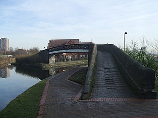
The Rochdale Branch Canal was a branch of the Rochdale Canal in north-west England which led close to Rochdale Town Centre. It was in use from 1794, and was bordered by the landscaped gardens of Lark Mill House on the western bank until the 1850s. A number of industries grew up around the branch, ranging from cotton mills and an iron and brass foundry in the early years, to a bakery and jam manufactory, woollen mills and sawmills later on. The branch declined with the main canal, and was little used after the 1920s, although not officially abandoned until 1952. It was filled in during the 1960s, and the site of the main basins now lies beneath the car park of a retail shopping centre.

<span class="mw-page-title-main">Laurel Mill, Middleton Junction</span> Former cotton mill in Manchester, England

Laurel Mill was a cotton spinning mill in the Mills Hill/Middleton Junction area of Chadderton, Oldham, Greater Manchester, England.

<span class="mw-page-title-main">River Sow Navigation</span>

The River Sow Navigation was a short river navigation in Staffordshire, England, which connected the Staffordshire and Worcestershire Canal to the centre of Stafford. There was a coal wharf in Stafford, and a single lock to connect it to the canal. It opened in 1816, and closed in the 1920s. There are proposals to restore the navigation as the Stafford Riverway Link.

<span class="mw-page-title-main">Pensnett Canal</span>

The Pensnett Canal, also called Lord Ward's Canal was a private 1.25 miles (2 km) long canal near Brierley Hill, West Midlands, England, which opened in 1840 and served the industrial enterprises of Lord Dudley's Estate. The engineer was Mathew Frost. Since its closure to navigation in 1950, much of it has been lost by overbuilding, but a small section at its junction with the Dudley Canal was restored in 1995, and the section through Brierley Hill remains in water, although it is polluted and not navigable.

References

  1. Hadfield & Biddle 1970 , pp. 273–275
  2. Hadfield & Biddle 1970 , p. 284
  3. Hadfield & Biddle 1970 , p. 287
  4. Dean 2001
  5. Hadfield & Biddle 1970 , p. 438
  6. 1 2 Ordnance Survey, 1:2500 map, 1929 and 2011
  7. 1 2 Ordnance Survey, 1:2500 maps, 1893, 1910, 1929, 1937 and 1956
  8. Nicholson 2006 , p. 170