Fare zone 6 is an outer zone of Transport for London's zonal fare system used for calculating the price of tickets for travel on the London Underground, London Overground, Docklands Light Railway, [1] National Rail services (since 2007), [2] and the Elizabeth line within Greater London. The zone was created in January 1991; previously it had formed part of zone 5 since May 1983. It extends from approximately 12–16 miles (19–26 km) from Piccadilly Circus. [3]
The following stations are within zone 6:
| Station | Local authority | Managed by | Notes |
|---|---|---|---|
| Banstead | Reigate and Banstead | Southern | Outside Greater London but included in this zone |
| Barnehurst | Bexley | Southeastern | |
| Bexley | Bexley | Southeastern | |
| Caterham | Tandridge | Southern | Outside Greater London but included in this zone |
| Chelsfield | Bromley | Southeastern | |
| Chessington North | Kingston | South Western Railway | |
| Chessington South | Kingston | South Western Railway | |
| Chipstead | Reigate and Banstead | Southern | Outside Greater London but included in this zone |
| Coulsdon South | Croydon | Southern | |
| Coulsdon Town | Croydon | Southern | |
| Crayford | Bexley | Southeastern | |
| Crews Hill | Enfield | Great Northern | |
| Debden | Epping Forest | London Underground | Outside Greater London but included in this zone |
| Elm Park | Havering | London Underground | |
| Elstree & Borehamwood | Hertsmere | Thameslink | Outside Greater London but included in this zone |
| Emerson Park | Havering | London Overground | |
| Enfield Lock | Enfield | Greater Anglia | |
| Epping | Epping Forest | London Underground | Outside Greater London but included in this zone |
| Epsom Downs | Reigate and Banstead | Southern | Outside Greater London but included in this zone |
| Erith | Bexley | Southeastern | |
| Ewell East | Epsom and Ewell | Southern | Outside Greater London but included in this zone |
| Ewell West | Epsom and Ewell | South Western Railway | Outside Greater London but included in this zone |
| Feltham | Hounslow | South Western Railway | |
| Fulwell | Richmond | South Western Railway | |
| Gidea Park | Havering | Elizabeth line | |
| Hadley Wood | Enfield | Great Northern | |
| Hampton | Richmond | South Western Railway | |
| Hampton Court | Elmbridge | South Western Railway | Outside Greater London but included in this zone |
| Hampton Wick | Richmond | South Western Railway | |
| Harold Wood | Havering | Elizabeth line | |
| Hatch End | Harrow | London Overground | |
| Hatton Cross | Hillingdon | London Underground | Also in zone 5 |
| Heathrow Terminals 2 & 3 | Hillingdon | Heathrow Express | Elizabeth line services only |
| Heathrow Terminals 2 & 3 | Hillingdon | London Underground | |
| Heathrow Terminal 4 | Hillingdon | London Underground | |
| Heathrow Terminal 4 | Hillingdon | Heathrow Express | Elizabeth line services only |
| Heathrow Terminal 5 | Hillingdon | Heathrow Express | Elizabeth line and London Underground services only |
| Hillingdon | Hillingdon | London Underground | |
| Hornchurch | Havering | London Underground | |
| Ickenham | Hillingdon | London Underground | |
| Kenley | Croydon | Southern | |
| Kingston | Kingston | South Western Railway | |
| Kingswood | Reigate and Banstead | Southern | Outside Greater London but included in this zone |
| Knockholt | Bromley | Southeastern | |
| Loughton | Epping Forest | London Underground | Outside Greater London but included in this zone |
| Moor Park | Three Rivers | London Underground | Outside Greater London but included in this zone Also in zone 7 |
| Northwood | Hillingdon | London Underground | |
| Northwood Hills | Hillingdon | London Underground | |
| Orpington | Bromley | Southeastern | |
| Purley | Croydon | Southern | |
| Purley Oaks | Croydon | Southern | |
| Rainham | Havering | c2c | |
| Reedham | Croydon | Southern | |
| Riddlesdown | Croydon | Southern | |
| Romford | Havering | Elizabeth line | |
| Ruislip | Hillingdon | London Underground | |
| Ruislip Manor | Hillingdon | London Underground | |
| Sanderstead | Croydon | Southern | |
| Slade Green | Bexley | Southeastern | |
| Surbiton | Kingston | South Western Railway | |
| St Mary Cray | Bromley | Southeastern | |
| Tadworth | Reigate and Banstead | Southern | Outside Greater London but included in this zone |
| Tattenham Corner | Reigate and Banstead | Southern | Outside Greater London but included in this zone |
| Teddington | Richmond | South Western Railway | |
| Thames Ditton | Elmbridge | South Western Railway | Outside Greater London but included in this zone |
| Theydon Bois | Epping Forest | London Underground | Outside Greater London but included in this zone |
| Turkey Street | Enfield | London Overground | |
| Upminster | Havering | c2c | |
| Upminster Bridge | Havering | London Underground | |
| Upper Warlingham | Tandridge | Southern | Outside Greater London but included in this zone |
| Uxbridge | Hillingdon | London Underground | |
| West Drayton | Hillingdon | Elizabeth line | |
| West Ruislip | Hillingdon | London Underground | |
| Whyteleafe | Tandridge | Southern | Outside Greater London but included in this zone |
| Whyteleafe South | Tandridge | Southern | Outside Greater London but included in this zone |
| Woodmansterne | Croydon | Southern |
The history of public transport authorities in London details the various organisations that have been responsible for the public transport network in and around London, England - including buses, coaches, trams, trolleybuses, Docklands Light Railway, and the London Underground.

Transport for London (TfL) is a local government body responsible for most of the transport network in London, United Kingdom.
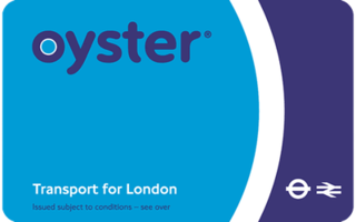
The Oyster card is a payment method for public transport in London in England, United Kingdom. A standard Oyster card is a blue credit-card-sized stored-value contactless smart card. It is promoted by Transport for London (TfL) and can be used on travel modes across London including London Buses, London Underground, the Docklands Light Railway (DLR), London Overground, Tramlink, some river boat services, and most National Rail services within the London fare zones. Since its introduction in June 2003, more than 86 million cards have been used.

The Travelcard is an inter-modal travel ticket for unlimited use on the London Underground, London Overground, Elizabeth line, Docklands Light Railway, London Trams, London Buses and National Rail services in the Greater London area. Travelcards can be purchased for a period of time varying from one day to a year, from Transport for London, National Rail and their agents. Depending on where it is purchased, and the length of validity, a Travelcard is either printed on a paper ticket with a magnetic stripe or encoded onto an Oyster card, Transport for London's contactless electronic smart card, or an ITSO smartcard issued by a National Rail train operating company. The cost of a Travelcard is determined by the area it covers and, for this purpose, London is divided into a number of fare zones. The Travelcard season ticket for unlimited travel on London Buses and the London Underground was launched on 22 May 1983 by London Transport. One Day Travelcards and validity on other transport modes were added from 1984 onwards. The introduction of the Travelcard caused an increase in patronage and reduced the number of tickets that needed to be purchased by passengers.
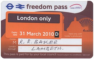
Freedom Pass is a concessionary travel scheme, which began in 1973, to provide free travel to residents of Greater London, England, for people with a disability or over the progressively increasing women's state pension age. The scheme is funded by local authorities and coordinated by London Councils. Originally the pass was a paper ticket, but since 2004 it has been encoded on to a contactless smartcard compatible with Oyster card readers.
The London Underground and Docklands Light Railway (DLR) metro systems of London, England uses a mix of paper and electronic smart-card ticketing.

London has an extensive and developed transport network which includes both public and private services. Journeys made by public transport systems account for 37% of London's journeys while private services accounted for 36% of journeys, walking 24% and cycling 2%. London's public transport network serves as the central hub for the United Kingdom in rail, air and road transport.
London Regional Transport (LRT) was the organisation responsible for most of the public transport network in London, England, between 1984 and 2000. In common with all London transport authorities from 1933 to 2000, the public name and operational brand of the organisation was London Transport from 1989, but until then it traded as LRT. This policy was reversed after the appointment of Sir Wilfrid Newton in 1989, who also abolished the recently devised LRT logo and restored the traditional roundel.
The use of Oyster pay as you go (PAYG) payment has now been implemented across National Rail services in the London Travelcard area, some additional stations served by c2c, Elizabeth line, Govia Thameslink Railway, Greater Anglia, and London Overground, Southeastern highspeed services within London, as well as Gatwick Express and Heathrow Express.

Transperth is the public transport system for Perth and surrounding areas in Western Australia. It is managed by the Public Transport Authority (PTA), a state government organisation, and consists of train, bus and ferry services. Bus operations are contracted out to Swan Transit, Path Transit and Transdev. Ferry operations are contracted out to Captain Cook Cruises. Train operations are done by the PTA through their Transperth Train Operations division.

Ruter AS is the public transport authority for Oslo and Akershus counties in Norway. Formally a limited company – 60% of its shares are owned by the Oslo county municipality and 40% by that of Akershus – it is responsible for the administration, funding, and marketing of public transport in the two counties, including buses, the Oslo Metro, Oslo Trams, and ferry services. Ruter also holds agreements with Entur concerning the regulation of fares on local and regional train services operated within the two counties.
The London Transport Executive was the executive agency within the Greater London Council, responsible for public transport in Greater London from 1970 to 1984. In common with all London transport authorities from 1933 to 2000, the public name and operational brand of the organisation was London Transport.

Rail service fares in Greater London and the surrounding area are calculated in accordance with the London fare zones system managed by Transport for London. Within London, all London Underground, National Rail, London Overground, TfL Rail and Docklands Light Railway stations are assigned to six fare zones. Fare zone 1 covers the central area and fare zones 2, 3, 4, 5 and 6 form concentric rings around it. Some National Rail stations and almost all Transport for London served stations outside Greater London in the home counties of Buckinghamshire, Essex, Hertfordshire and Surrey are either included in fare zones 4, 5 or 6 or in extended zones beyond these. Transport for London fare zones are also known simply as zones or travelcard zones, referring to their use in calculating prices for the travelcards or pay-as-you-go caps. Before flat fares were introduced in 2004, fare zones were used on the London Buses network. London fare zones are also used for calculating the cost of single and return paper tickets, Oyster card pay-as-you-go fares and season tickets.

Zone 1 of the Manchester Metrolink light rail network is the heart of the system where all of the other lines converge. Its boundaries are broadly equivalent to those of Manchester city centre, and approximately mirror the city's Inner Ring Road. Within Zone 1, first opened in 1992 as the City Zone, trams largely run along semi-pedestrianised streets rather than on their own separate alignment. The original route between the Altrincham and Bury lines ran to Victoria station via Market Street and High Street, and was soon joined by a branch to Piccadilly station by a three-way delta junction. A second route between the South-West and North-Eastern parts of the network was built to ease congestion on the original line. Opened in 2017, the Second City Crossing (2CC) added one additional stop to the network.