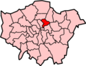
A map showing the wards of Shoreditch Metropolitan Borough as they appeared in 1916.
The civil parish was within the Ossulstone hundred and, from the 17th century, the Tower division. It was entrusted with various administrative functions from the 17th century. The vestry also had responsibility for highways and burials. In 1855 the parish was included in the area of the Metropolitan Board of Works, and the vestry elected two members of the board.
Under the Metropolis Management Act 1855 any parish that exceeded 2,000 ratepayers was to be divided into wards; as such the incorporated vestry of St Leonard Shoreditch was divided into eight wards (electing vestrymen): No. 1 or Moorfields (18), No. 2 or Church (21), No. 3 or Hoxton (21), No. 4 or Wenlock (18), No. 5 or Whitmore (12), No. 6 or Kingsland (12), No. 7 or Haggerstone (9) and No. 8 or Acton (9).[1][2]
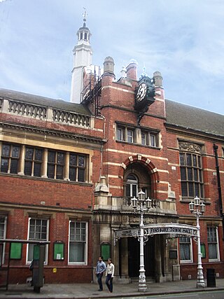
The Hoxton Street façade of the former Shoreditch workhouse. The site stretches to Kingsland Road, where many of the buildings remain as Saint Leonard's hospital.
The precursor of the Saint Leonard's workhouse was housed in several houses in Hoxton. In 1731, that site housed 84 inmates. Saint Leonard's new, three-story workhouse (with infirmary and apothecary) was opened in 1777, thanks to a levy tax passed by an Act of Parliament in 1774. The Shoreditch Vestry built this workhouse on the Parish Poor Trustees' "Land of Promise," on Kingsland Road.[4]
St Leonard's parish circumvented the 1834 Poor Law Amendment Act, because it was administered under its own Act. In 1847, a sub-committee of Parliament found the conditions in the workhouse to be very poor.
Ecclesiastical parish
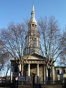
St Leonard's parish church. (January 2006)
St Leonard's parish was within the Diocese of London. As the population increased the parish was divided:[5]
In 1830 the areas of Haggerston and Hoxton were constituted as separate parishes.
In 1841 a new parish of "St James, Curtain Road" was created.
In 1848 part of Saint Leonard's parish helped to form the parish of "St Mark, Old Street".
In 1862 St Leonard's parish was again divided to create the parish of "Shoreditch, St Michael".
In 1866 a new parish of "Holy Trinity, Shoreditch" was formed from part of Saint Leonard's and part of neighbouring parish of Bethnal Green.
In 1872 the parish of "Shoreditch, St Agatha" was created from part of Saint James, Curtain Road.
Later decreases in population led to a number of these parishes being combined in the 20th century. For instance, in 1915 Saint Agatha's parish was absorbed by St James, and in 1972 a merged parish of "Shoreditch, St Leonard with St Michael" was formed.
Hoxton is an area in the London Borough of Hackney, England, and on the north-western fringes of the East End, the historic core of wider east London. It was historically in the county of Middlesex until 1889. It lies immediately north of the City of London financial district, and was once part of the civil parish and subsequent Metropolitan Borough of Shoreditch, prior to its incorporation into the London Borough of Hackney.
Shoreditch is an area in London, England and is located in the London Borough of Hackney alongside neighbouring parts of Tower Hamlets, which are also perceived as part of the area due to historic ecclesiastical links. Shoreditch lies just north-east of the border with the City of London and is considered to be a part of London's East End.
St Pancras was a civil parish and metropolitan borough in London, England. It was an ancient parish in the county of Middlesex, governed by an administrative vestry. The parish was included in the area of responsibility of the Metropolitan Board of Works in 1855 and became part of the County of London in 1889. The parish of St Pancras became a metropolitan borough in 1900, following the London Government Act 1899, with the parish vestry replaced by a borough council. In 1965 the borough was abolished and its former area became part of the London Borough of Camden in Greater London.
Hampstead was a civil parish and metropolitan borough in London, England. It was an ancient parish in the county of Middlesex, governed by an administrative vestry. The parish was included in the area of responsibility of the Metropolitan Board of Works in 1855 and became part of the County of London in 1889. The parish of Hampstead became a metropolitan borough in 1900, following the London Government Act 1899, with the parish vestry replaced by a borough council. In 1965 the borough was abolished and its former area became part of the London Borough of Camden in Greater London.
The Metropolitan Borough of Finsbury was a metropolitan borough within the County of London from 1900 to 1965, when it was amalgamated with the Metropolitan Borough of Islington to form the London Borough of Islington.
Islington was a civil parish and metropolitan borough in London, England. It was an ancient parish within the county of Middlesex, and formed part of The Metropolis from 1855. The parish was transferred to the County of London in 1889 and became a metropolitan borough in 1900. It was amalgamated with the Metropolitan Borough of Finsbury to form the London Borough of Islington in Greater London in 1965.
The Metropolitan Borough of Hackney was a metropolitan borough of the County of London from 1900 to 1965. Its area became part of the London Borough of Hackney.
Bethnal Green was a civil parish and a metropolitan borough of the County of London between 1899 and 1965, when it was merged with the Metropolitan Borough of Stepney and the Metropolitan Borough of Poplar to form the London Borough of Tower Hamlets.
Poplar was a local government district in the metropolitan area of London, England. It was formed as a district of the Metropolis in 1855 and became a metropolitan borough in the County of London in 1900. It comprised Poplar, Millwall, Bromley-by-Bow and Bow as well as Old Ford, Fish Island and Cubitt Town.
The Metropolitan Borough of Shoreditch was a metropolitan borough of the County of London between 1899 and 1965, when it was merged with the Metropolitan Borough of Stoke Newington and the Metropolitan Borough of Hackney to form the London Borough of Hackney.
Stoke Newington was an ancient parish in the county of Middlesex. It was both a civil parish, used for administrative purposes, and an ecclesiastical parish of the Church of England.
Hackney was a parish in the historic county of Middlesex. The parish church of St John-at-Hackney was built in 1789, replacing the nearby former 16th-century parish church dedicated to St Augustine. The original tower of that church was retained to hold the bells until the new church could be strengthened; the bells were finally removed to the new St John's in 1854. See details of other, more modern, churches within the original parish boundaries below.
Hoxton was a borough constituency centred on the Hoxton district of London. It returned one Member of Parliament (MP) to the House of Commons of the Parliament of the United Kingdom, elected by the first past the post system.
Haggerston, formally known as the "Haggerston Division of Shoreditch", was a borough constituency centred on the Haggerston district of the Metropolitan Borough of Shoreditch in London. It returned one Member of Parliament (MP) to the House of Commons of the Parliament of the United Kingdom, elected by the first past the post system.
St George Hanover Square was a civil parish in the metropolitan area of Westminster, Middlesex, later Greater London, England. The creation of the parish accompanied the building of the Church of St George's, Hanover Square, constructed by the Commission for Building Fifty New Churches to meet the demands of the growing population. The parish was formed in 1724 from part of the ancient parish of St Martin in the Fields in the Liberty of Westminster and county of Middlesex. It included some of the most fashionable areas of the West End, including Belgravia and Mayfair. Civil parish administration, known as a select vestry, was dominated by members of the British nobility until the parish adopted the Vestries Act 1831. The vestry was reformed again in 1855 by the Metropolis Management Act. In 1889 the parish became part of the County of London and the vestry was abolished in 1900, replaced by Westminster City Council. The parish continued to have nominal existence until 1922. As created, it was a parish for both church and civil purposes, but the boundaries of the ecclesiastical parish were adjusted in 1830, 1835 and 1865.
Westminster St James was a civil parish in the metropolitan area of London, England. The creation of the parish followed the building of the Church of St James, Piccadilly, in 1684. After several failed attempts, the parish was formed in 1685 from part of the ancient parish of St Martin in the Fields in the Liberty of Westminster and county of Middlesex. It included part of the West End of London, taking in sections of Soho, Mayfair and St James's. Civil parish administration was in the hands of a select vestry until the parish adopted the Vestries Act 1831. The vestry was reformed again in 1855 by the Metropolis Management Act. In 1889 the parish became part of the County of London and the vestry was abolished in 1900, replaced by Westminster City Council. The parish continued to have nominal existence until 1922.
St Martin in the Fields was a civil parish in the county of Middlesex, later part of the new County of London, England. It took its name from the Church of St Martin-in-the-Fields and was within the Liberty of Westminster. Within its boundaries were the former extra-parochial areas of Buckingham Palace and St James's Palace.
St Margaret was an ancient parish in the City and Liberty of Westminster and the county of Middlesex. It included the core of modern Westminster, including the Palace of Westminster and the area around, but not including Westminster Abbey. It was divided into St Margaret's and St John's in 1727, to coincide with the building of the Church of St John the Evangelist, constructed by the Commission for Building Fifty New Churches in Smith Square to meet the demands of the growing population, but there continued to be a single vestry for the parishes of St Margaret and St John. This was reformed in 1855 by the Metropolis Management Act, and the two parishes formed the Westminster District until 1887. St Margaret and St John became part of the County of London in 1889. The vestry was abolished in 1900, to be replaced by Westminster City Council, but St Margaret and St John continued to have a nominal existence until 1922.
Hackney was a local government district within the metropolitan area of London, England from 1855 to 1894. It was formed by the Metropolis Management Act 1855 and was governed by the Hackney District Board of Works, which consisted of elected vestrymen. It was in the part of the county of Middlesex that was within the area of the Metropolitan Board of Works. In 1889 it became part of the County of London and the district board functioned as a local authority under the London County Council.
St George in the East, historically known as Wapping-Stepney, was an ancient parish, in the London Borough of Tower Hamlets, England. The place name is no longer widely used.
This page is based on this Wikipedia article Text is available under the CC BY-SA 4.0 license; additional terms may apply. Images, videos and audio are available under their respective licenses.