
Islington was a civil parish and metropolitan borough in London, England. It was an ancient parish within the county of Middlesex, and formed part of The Metropolis from 1855. The parish was transferred to the County of London in 1889 and became a metropolitan borough in 1900. It was amalgamated with the Metropolitan Borough of Finsbury to form the London Borough of Islington in Greater London in 1965.

Hammersmith was a civil parish and metropolitan borough in London, England. It was formed as a civil parish in 1834 from the chapelry of Hammersmith that had existed in the ancient parish of Fulham, Middlesex since 1631. The parish was grouped with Fulham as the Fulham District from 1855 until 1886, when separate parish administration was restored. In 1889 it became part of the County of London and in 1900 it became a metropolitan borough. It included Hammersmith, Wormwood Scrubs, Old Oak Common and Shepherd's Bush. In 1965 it was abolished and became the northern part of the London Borough of Hammersmith, since 1979 renamed the London Borough of Hammersmith and Fulham.

Bethnal Green was a civil parish and a metropolitan borough in the East End of London, England.

Poplar was a local government district in the metropolitan area of London, England. It was formed as a district of the Metropolis in 1855 and became a metropolitan borough in the County of London in 1900. It comprised Poplar, Millwall, Bromley-by-Bow and Bow as well as Old Ford, Fish Island and Cubitt Town.

Hackney was a parish in the historic county of Middlesex. The parish church of St John-at-Hackney was built in 1789, replacing the nearby former 16th-century parish church dedicated to St Augustine. The original tower of that church was retained to hold the bells until the new church could be strengthened; the bells were finally removed to the new St John's in 1854. See details of other, more modern, churches within the original parish boundaries below.
Bermondsey was a parish in the metropolitan area of London, England.

Strand was a local government district within the metropolitan area of London, England, from 1855 to 1900.

Holborn was a local government district in the metropolitan area of London to the north west of the City of London from 1855 to 1900.

St George Hanover Square was a civil parish in the metropolitan area of London, England. The creation of the parish accompanied the building of the Church of St George's, Hanover Square, constructed by the Commission for Building Fifty New Churches to meet the demands of the growing population. The parish was formed in 1724 from part of the ancient parish of St Martin in the Fields in the Liberty of Westminster and county of Middlesex. It included some of the most fashionable areas of the West End of London, including Belgravia and Mayfair. Civil parish administration, known as a select vestry, was dominated by members of the British nobility until the parish adopted the Vestries Act 1831. The vestry was reformed again in 1855 by the Metropolis Management Act. In 1889 the parish became part of the County of London and the vestry was abolished in 1900, replaced by Westminster City Council. The parish continued to have nominal existence until 1922. As created, it was a parish for both church and civil purposes, but the boundaries of the ecclesiastical parish were adjusted in 1830, 1835 and 1865.
Westminster St James was a civil parish in the metropolitan area of London, England. The creation of the parish followed the building of the Church of St James, Piccadilly, in 1684. After several failed attempts, the parish was formed in 1685 from part of the ancient parish of St Martin in the Fields in the Liberty of Westminster and county of Middlesex. It included part of the West End of London, taking in sections of Soho, Mayfair and St James's. Civil parish administration was in the hands of a select vestry until the parish adopted the Vestries Act 1831. The vestry was reformed again in 1855 by the Metropolis Management Act. In 1889 the parish became part of the County of London and the vestry was abolished in 1900, replaced by Westminster City Council. The parish continued to have nominal existence until 1922.
Plumstead (1855–1894) and then Lee (1894–1900) was a local government district within the metropolitan area of London from 1855 to 1900. It was formed as the Plumstead district by the Metropolis Management Act 1855 and was governed by the Plumstead District Board of Works, which consisted of elected vestrymen.
Lewisham was a local government district within the metropolitan area of London, England from 1855 to 1900. It was formed by the Metropolis Management Act 1855 and was governed by the Lewisham District Board of Works, which consisted of elected vestrymen.

Greenwich was a local government district within the metropolitan area of London, England from 1855 to 1900. It was formed by the Metropolis Management Act 1855 and was governed by the Greenwich District Board of Works, which consisted of elected vestrymen.
Fulham was a local government district within the metropolitan area of London, England from 1855 to 1886. It was formed by the Metropolis Management Act 1855 and was governed by the Fulham District Board of Works, which consisted of elected vestrymen. It was in the part of the county of Middlesex that was within the area of the Metropolitan Board of Works. It occupied broadly the same area as ancient parish of Fulham and that of the current London Borough of Hammersmith and Fulham.
Hackney was a local government district within the metropolitan area of London, England from 1855 to 1894. It was formed by the Metropolis Management Act 1855 and was governed by the Hackney District Board of Works, which consisted of elected vestrymen. It was in the part of the county of Middlesex that was within the area of the Metropolitan Board of Works. In 1889 it became part of the County of London and the district board functioned as a local authority under the London County Council.
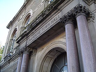
Limehouse was a local government district within the metropolitan area of London, England from 1855 to 1900.

Wandsworth was a local government district within the metropolitan area of London, England from 1855 to 1900. It was formed by the Metropolis Management Act 1855 and was governed by the Wandsworth District Board of Works, which consisted of elected vestrymen.

St Saviour's was a local government district within the metropolitan area of London, England from 1855 to 1900. It was formed by the Metropolis Management Act 1855 and was governed by the St Saviour's District Board of Works, which consisted of elected vestrymen.
St George in the East, historically known as Wapping-Stepney, was an ancient parish, in the London Borough of Tower Hamlets, England. The place name is no longer widely used.

Woolwich, also known as Woolwich St Mary, was an ancient parish containing the town of Woolwich on the south bank of the Thames and North Woolwich on the north bank. The parish was governed by its vestry from the 16th century to 1852, based in the Church of St Mary until 1842, after which in the purpose-built Woolwich Town Hall. The parish adopted the Public Health Act 1848 and was governed by the Woolwich Local Board of Health from 1852. When the parish became part of the district of the Metropolitan Board of Works in 1855 the local board was treated as if it were an incorporated vestry. It was in the county of Kent until it was transferred to London in 1889. In 1900 it was amalgamated with other parishes to form the Metropolitan Borough of Woolwich and had only nominal existence until it was abolished as a civil parish in 1930. Since 1965 it has been split between the Royal Borough of Greenwich and the London Borough of Newham.


