The County of London was a county of England from 1889 to 1965, corresponding to the area known today as Inner London. It was created as part of the general introduction of elected county government in England, by way of the Local Government Act 1888. The Act created an administrative County of London, which included within its territory the City of London. However, the City of London and the County of London formed separate ceremonial counties for "non-administrative" purposes. The local authority for the county was the London County Council (LCC), which initially performed only a limited range of functions, but gained further powers during its 76-year existence. The LCC provided very few services within the City of London, where the ancient Corporation monopolised local governance. In 1900, the lower-tier civil parishes and district boards were replaced with 28 new metropolitan boroughs. The territory of the county was 74,903 acres (303.12 km2) in 1961. During its existence there was a long-term decline in population as more residents moved into the outer suburbs; there were periodic reviews of the local government structures in the greater London area and several failed attempts to expand the boundaries of the county. In 1965, the London Government Act 1963 replaced the county with the much larger Greater London administrative area.
Paddington was a civil parish and metropolitan borough in London, England. It was an ancient parish in the county of Middlesex, governed by an administrative vestry. The parish was included in the area of responsibility of the Metropolitan Board of Works in 1855 and became part of the County of London in 1889. The parish of Paddington became a metropolitan borough in 1900, following the London Government Act 1899, with the parish vestry replaced by a borough council. In 1965 the borough was abolished and its former area became part of the City of Westminster in Greater London.

St Pancras was a civil parish and metropolitan borough in London, England. It was an ancient parish in the county of Middlesex, governed by an administrative vestry. The parish was included in the area of responsibility of the Metropolitan Board of Works in 1855 and became part of the County of London in 1889. The parish of St Pancras became a metropolitan borough in 1900, following the London Government Act 1899, with the parish vestry replaced by a borough council. In 1965 the borough was abolished and its former area became part of the London Borough of Camden in Greater London.
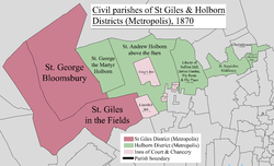
The Metropolitan Borough of Holborn was a metropolitan borough in the County of London between 1900 and 1965, when it was amalgamated with the Metropolitan Borough of St Pancras and the Metropolitan Borough of Hampstead to form the London Borough of Camden.

Islington was a civil parish and metropolitan borough in London, England. It was an ancient parish within the county of Middlesex, and formed part of The Metropolis from 1855. The parish was transferred to the County of London in 1889 and became a metropolitan borough in 1900. It was amalgamated with the Metropolitan Borough of Finsbury to form the London Borough of Islington in Greater London in 1965.

Battersea was a civil parish and metropolitan borough in the County of London, England. In 1965, the borough was abolished and its area combined with parts of the Metropolitan Borough of Wandsworth to form the London Borough of Wandsworth. The borough was administered from Battersea Town Hall on Lavender Hill. That building is now Battersea Arts Centre.

Poplar was a local government district in the metropolitan area of London, England. It was formed as a district of the Metropolis in 1855 and became a metropolitan borough in the County of London in 1900. It comprised Poplar, Millwall, Bromley-by-Bow and Bow.
Bermondsey was a parish in the metropolitan area of London, England.

Strand was a local government district within the metropolitan area of London, England, from 1855 to 1900.

Holborn was a local government district in the metropolitan area of London to the north west of the City of London from 1855 to 1900.

St George Hanover Square was a civil parish in the metropolitan area of London, England. The creation of the parish accompanied the building of the St George's Hanover Square Church, constructed by the Commission for Building Fifty New Churches to meet the demands of the growing population. The parish was formed in 1724 from part of the quite early medieval parish of Saint Martin in the Fields in the consequent Liberty of Westminster, hundred of Ossulstone and county of Middlesex. It included some of the most fashionable areas of the West End of London, including Belgravia and Mayfair. Civil parish administration, known as a select vestry, was dominated by members of the British nobility until the parish adopted the Vestries Act 1831. The vestry was reformed again in 1855 by the Metropolis Management Act. In 1889 the parish became part of the County of London and the vestry was abolished in 1900, replaced by Westminster City Council. The parish continued to have nominal existence until 1922. As created, it was a parish for both church and civil purposes, but the boundaries of the ecclesiastical parish were adjusted in 1830, 1835 and 1865.
Westminster St James was a civil parish in the metropolitan area of London, England. The creation of the parish followed the building of the Church of St James, Piccadilly in 1684. After several failed attempts, the parish was formed in 1685 from part of the ancient parish of St Martin in the Fields in the Liberty of Westminster and county of Middlesex. It included part of the West End of London, taking in sections of Soho, Mayfair and St James's. Civil parish administration was in the hands of a select vestry until the parish adopted the Vestries Act 1831. The vestry was reformed again in 1855 by the Metropolis Management Act. In 1889 the parish became part of the County of London and the vestry was abolished in 1900, replaced by Westminster City Council. The parish continued to have nominal existence until 1922.
St Anne Within the Liberty of Westminster, also known as St Anne Soho, was a civil parish in the metropolitan area of London, England. The creation of the parish accompanied the building of St Anne's Church, Soho to meet the demands of the growing population. The parish was formed in 1687 from part of the ancient parish of St Martin in the Fields in the Liberty of Westminster and county of Middlesex. It included the eastern section of the contemporary districts of Soho to the north of Shaftesbury Avenue and Chinatown to the south of it. Initially controlled by a select vestry, the parish was governed by an open vestry of all inhabitants until 1855, when the vestry was superseded for most purposes by the Strand District Board of Works. In 1889 the parish became part of the County of London and in 1900 the local authority became Westminster City Council. The parish continued to have nominal existence until 1922.

Greenwich was a local government district within the metropolitan area of London, England from 1855 to 1900. It was formed by the Metropolis Management Act 1855 and was governed by the Greenwich District Board of Works, which consisted of elected vestrymen.
Fulham was a local government district within the metropolitan area of London, England from 1855 to 1886. It was formed by the Metropolis Management Act 1855 and was governed by the Fulham District Board of Works, which consisted of elected vestrymen. It was in the part of the county of Middlesex that was within the area of the Metropolitan Board of Works. It occupied broadly the same area as ancient parish of Fulham and that of the current London Borough of Hammersmith and Fulham.
Hackney was a local government district within the metropolitan area of London, England from 1855 to 1894. It was formed by the Metropolis Management Act 1855 and was governed by the Hackney District Board of Works, which consisted of elected vestrymen. It was in the part of the county of Middlesex that was within the area of the Metropolitan Board of Works. In 1889 it became part of the County of London and the district board functioned as a local authority under the London County Council.
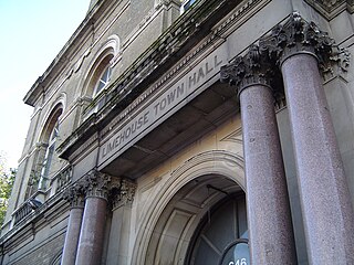
Limehouse was a local government district within the metropolitan area of London, England from 1855 to 1900.

Wandsworth was a local government district within the metropolitan area of London, England from 1855 to 1900. It was formed by the Metropolis Management Act 1855 and was governed by the Wandsworth District Board of Works, which consisted of elected vestrymen.

Woolwich, also known as Woolwich St Mary, was an ancient parish containing the town of Woolwich on the south bank of the Thames and North Woolwich on the north bank. The parish was governed by its vestry from the 16th century to 1852, based in the Church of St Mary until 1842, after which in the purpose-built Woolwich Town Hall. The parish adopted the Public Health Act 1848 and was governed by the Woolwich Local Board of Health from 1852. When the parish became part of the district of the Metropolitan Board of Works in 1855 the local board was treated as if it were an incorporated vestry. It was in the county of Kent until it was transferred to London in 1889. In 1900 it was amalgamated with other parishes to form the Metropolitan Borough of Woolwich and had only nominal existence until it was abolished as a civil parish in 1930. Since 1965 it has been split between the Royal Borough of Greenwich and the London Borough of Newham.

The Liberty of Glasshouse Yard was an extra-parochial liberty adjacent to the City of London. The liberty took its name from a glass manufacturing works established there. The area now forms part of the London Borough of Islington.