Hampstead Town Hall

Last updated

Hampstead Town Hall
Former Hampstead town hall, Haverstock Hill - geograph.org.uk - 415063.jpg
Hampstead Town Hall
Location Hampstead
Coordinates 51°33′04″N0°09′59″W / 51.5510°N 0.1665°W / 51.5510; -0.1665
Built1878
Architect Henry Edward Kendall and Frederick Mew
Architectural style(s) Italianate style
Listed Building – Grade II
Designated1 August 1994
Reference no.1378818
Camden London UK location map.svg
Red pog.svg
Shown in Camden

Hampstead Town hall is a municipal building on Haverstock Hill, Hampstead, London. It is a Grade II listed building. [1]

History

The facility was commissioned by the Vestry of St John who had previously met in the offices of the local workhouse. [2] After this arrangement became inadequate for their needs, civic leaders decided to build a dedicated vestry hall: the site chosen for the new building had previously been occupied by part of the Belsize House Estate. [3] They had also considered a possible site on what became Hampstead Hill Gardens. [4]

The new building was designed by Henry Edward Kendall and Frederick Mew in the Italianate style and was built by William Shepherd of Bermondsey; the building was opened without ceremony in June 1878. [2] The design involved a symmetrical main frontage with seven bays facing onto the Haverstock Hill; the central section featured wide steps leading up to a doorway flanked with windows with integrated oculi on the ground floor; there were three tall round headed windows flanked by brick pilasters on the first floor with a pediment above. [1] Internally, the principal rooms were the council chamber on the ground floor [5] and the assembly hall on the first floor. [1] Alterations made in 1886, to a design by Frederick Mew, included a bell tower containing a staircase in the south west corner of the building. [1]

Meetings of the Hampstead Antiquarian and Historical Society were held at the town hall from 1897. [6] The building became the headquarters of the Metropolitan Borough of Hampstead when it was formed in 1900 [7] and a substantial extension was built to a design by John Murray in the Baroque style, extending the building south west along Belsize Avenue in 1911. [2] The suffragette, Emmeline Pankhurst, gave a speech in the hall in 1913, as did the politician Sir Oswald Mosley, in 1938, and the anti-racism campaigner David Pitt, in 1959. [8]

During the Second World War, an air raid precautions centre was built in the grounds. [8] It ceased to function as the local of seat of government when the enlarged London Borough of Camden was formed in 1965. [9] Instead it served as the local register office: notable weddings included the singer, Cleo Laine, to the musician, John Dankworth, in 1958, the actor, Dudley Moore, to the actress, Suzy Kendall, in 1968, and the actress, Judi Dench, to the actor, Michael Williams, in 1971, as well as the singer, Lulu, to hair stylist, John Frieda in 1976. [10]

Large sections of the building had fallen into a state of disrepair by the 1990s. [11] However, it was subsequently restored and converted, to the designs of Burrell Foley Fischer, with the addition of a large glass atrium; it was re-opened for use as an arts centre by the Prince of Wales in 1999. [12]

Related Research Articles

<span class="mw-page-title-main">Chalk Farm</span> Human settlement in England

Chalk Farm is a small urban district of north west London, lying immediately north of Camden Town, in the London Borough of Camden.

<span class="mw-page-title-main">Hampstead</span> Area of Camden in London, England

Hampstead is an area in London, England, which lies four miles northwest of Charing Cross, and extends from the A5 road to Hampstead Heath, a large, hilly expanse of parkland. The area forms the northwest part of the London Borough of Camden, a borough in Inner London which for the purposes of the London Plan is designated as part of Central London.

<span class="mw-page-title-main">Metropolitan Borough of Hampstead</span> Former local authority in London

Hampstead was a civil parish and metropolitan borough in London, England. It was an ancient parish in the county of Middlesex, governed by an administrative vestry. The parish was included in the area of responsibility of the Metropolitan Board of Works in 1855 and became part of the County of London in 1889. The parish of Hampstead became a metropolitan borough in 1900, following the London Government Act 1899, with the parish vestry replaced by a borough council. In 1965 the borough was abolished and its former area became part of the London Borough of Camden in Greater London.

<span class="mw-page-title-main">Belsize Park tube station</span> London Underground station

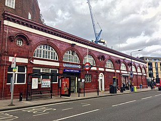
Belsize Park is a London Underground station in Belsize Park, north-west London. It is on the Edgware branch of the Northern line, between Hampstead and Chalk Farm stations, and is in Travelcard Zone 2. It stands at the northern end of Haverstock Hill. In July 2011 it became a Grade II listed building.

<span class="mw-page-title-main">Gospel Oak</span> Human settlement in England

Gospel Oak is an inner urban area of north west London in the London Borough of Camden at the very south of Hampstead Heath. The neighbourhood is positioned between Hampstead to the north-west, Dartmouth Park to the north-east, Kentish Town to the south-east, and Belsize Park to the south-west. Gospel Oak lies across the NW5 and NW3 postcodes and is served by Gospel Oak station on the London Overground. The North London Suburb, Gospel Oak, has many schools around it.

<span class="mw-page-title-main">Chalk Farm tube station</span> London Underground station

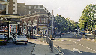
Chalk Farm is a London Underground station near Camden Town in the London Borough of Camden. It is on the Edgware branch of the Northern line between Belsize Park and Camden Town stations. For ticketing purposes, Chalk Farm falls in Travelcard Zone 2. With slightly under five million entries and exits in 2011, Chalk Farm is one of the busiest stations on the Edgware branch of the Northern line.

<span class="mw-page-title-main">Belsize Park</span> Area in Hampstead, London

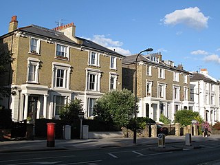
Belsize Park is an affluent residential area of Hampstead in the London Borough of Camden, England.

<span class="mw-page-title-main">Hillfield Court</span>

Hillfield Court is a prominent art deco residential mansion block in Belsize Park, in the London Borough of Camden, built in 1934. It is located off Belsize Avenue and can also be accessed from Glenloch Road. It is one of the many purpose built mansion blocks on Haverstock Hill between Chalk Farm and Hampstead. It is close to the amenities near Belsize Park tube station, as well as the shops of Belsize Village, South End Green and Hampstead.

<span class="mw-page-title-main">Holborn Town Hall</span> Municipal building in London, England

Holborn Town hall is a municipal building on High Holborn, Holborn, London. It is a Grade II listed building.

<span class="mw-page-title-main">Camden Town Hall</span> Municipal building in London, England

Camden Town Hall, known as St Pancras Town Hall until 1965, is the headquarters of Camden London Borough Council. The main entrance is in Judd street with its northern elevation extending along Euston Road, opposite the main front of St Pancras railway station. It has been Grade II listed since 1996.

<span class="mw-page-title-main">Haverstock</span> Human settlement in England

Haverstock is an area of the London Borough of Camden: specifically the east of Belsize Park, north of Chalk Farm and west of Kentish Town. It is centred on Queens Crescent and Malden Road. Gospel Oak is to the north, Camden Town to the south.

The London Borough of Camden was created in 1965 from the former area of the metropolitan boroughs of Hampstead, Holborn, and St Pancras, which had formed part of the County of London. The borough was named after Camden Town, which had gained its name from Charles Pratt, 1st Earl Camden in 1795. Since the 17th century, many famous people have lived in its various districts and neighbourhoods.

<span class="mw-page-title-main">London Borough of Camden</span> London borough in United Kingdom

The London Borough of Camden is a London borough in Inner London, England. Camden Town Hall, on Euston Road, lies 1.4 mi (2.3 km) north of Charing Cross. The borough was established on 1 April 1965 and includes the former Central London borough of Holborn, and St Pancras and Hampstead.

<span class="mw-page-title-main">2010 Camden London Borough Council election</span>

The 2010 Camden Council election took place on 6 May 2010 to elect members of Camden London Borough Council in London, England. The whole council was up for election and the Labour party gained overall control of the council from no overall control.

<span class="mw-page-title-main">Belsize (ward)</span> Electoral ward in the London borough of Camden

Belsize is a ward in the London Borough of Camden, in the United Kingdom. The ward covers most of Belsize Park, between Haverstock Hill, Swiss Cottage, and Primrose Hill.

<span class="mw-page-title-main">Luisa Porritt</span> British Liberal Democrat politician

Luisa Manon Porritt is a British Liberal Democrat politician.

<span class="mw-page-title-main">Old Town Hall, Richmond</span> Municipal building in London, England

The Old Town Hall, Richmond on Whittaker Avenue in Richmond, London is a former municipal building which from 1893 to 1965 served as the town hall for the Municipal Borough of Richmond.

<span class="mw-page-title-main">Camberwell Town Hall, London</span> Municipal building in London, England

Camberwell Town Hall is a municipal building in Peckham Road, Camberwell, London, England.

<span class="mw-page-title-main">Belsize Avenue</span> Street in London, England

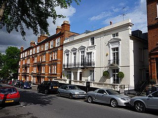
Belsize Avenue is a street in the Belsize Park area of Hampstead. Located in the London Borough of Camden, it runs from Haverstock Hill westwards to a junction with Belsize Terrace and Belsize Park Gardens. It is the former carriageway approach to Belsize House, a country estate that occupied the area until it was demolished in 1853 to allow residential development. A number of houses in the street were built by William Willett around 1873.

References

  1. 1 2 3 4 Historic England. "Hampstead Town Hall and attached walls and piers (1378818)". National Heritage List for England . Retrieved 28 April 2020.
  2. 1 2 3 "London's Town Halls". Historic England. p. 32. Retrieved 25 April 2020.
  3. "Ordnance Survey Map". 1871. Retrieved 6 September 2020.
  4. Wade, Christopher. The Streets of Belsize. Camden History Society, 1991. p.80
  5. "1878 – Vestry Hall, Hampstead, London". Archiseek. 20 July 2009. Retrieved 6 September 2020.
  6. Baker, T F T; Bolton, Diane K; Croot, Patricia E C (1989). "'Hampstead: Social and Cultural Activities', in A History of the County of Middlesex: Volume 9, Hampstead, Paddington, ed. C R Elrington". London: British History Online. pp. 81–91. Retrieved 29 April 2020.
  7. Terry, Warner; Morle, Bartlett (1899). "London Government Act 1899". Butterworth & Co. Retrieved 28 April 2020.
  8. 1 2 "Old Hampstead Town Hall". Open House London. Archived from the original on 19 June 2020. Retrieved 28 April 2020.
  9. "Local Government Act 1963". Legislation.gov.uk. Retrieved 25 April 2020.
  10. "Hampstead Town Hall Marriages". Wac Arts. 29 April 2019. Retrieved 6 September 2020.
  11. "Our Building". Wac Arts. Retrieved 28 April 2020.
  12. "Hampstead Town Hall: Open House tours give the public the chance to see inside historic building". Ham and High. 23 September 2019. Retrieved 6 September 2020.