
Bermondsey is a district in southeast London, part of the London Borough of Southwark, England, 2.5 miles (4.0 km) southeast of Charing Cross. To the west of Bermondsey lies Southwark, to the east Rotherhithe and Deptford, to the south Walworth and Peckham, and to the north is Wapping across the River Thames. It lies within the historic county boundaries of Surrey. During the Industrial Revolution Bermondsey became a centre for manufacturing, particularly in relation to tanning. More recently it has experienced regeneration including warehouse conversions to flats and the provision of new transport links.
Rotherhithe is a district of South London, England, and part of the London Borough of Southwark. It is on a peninsula on the south bank of the Thames, facing Wapping, Shadwell and Limehouse on the north bank, with the Isle of Dogs to the east. It borders Bermondsey to the west and Deptford to the south-east. The district is a part of the Docklands area.

Old Street is a 1-mile (1.6 km) street in inner north-east Central London, England that runs west to east from Goswell Road in Clerkenwell, in the London Borough of Islington, via St Luke's and Old Street Roundabout, to the crossroads where it meets Shoreditch High Street (south), Kingsland Road (north) and Hackney Road (east) in Shoreditch in the London Borough of Hackney.

Old Kent Road is a major thoroughfare in South East London, England, passing through the London Borough of Southwark. It was originally part of an ancient trackway that was paved by the Romans and used by the Anglo-Saxons who named it Wæcelinga Stræt. It is now part of the A2, a major road from London to Dover. The road was important in Roman times linking London to the coast at Richborough and Dover via Canterbury. It was a route for pilgrims in the Middle Ages as portrayed in Chaucer's Canterbury Tales, when Old Kent Road was known as Kent Street. The route was used by soldiers returning from the Battle of Agincourt.

Spa Road railway station in Bermondsey, south-east London, was the original terminus of the capital's first railway, the London and Greenwich Railway (L&GR). It was located on and takes its name from Spa Road.
Kingsland was a small road-side settlement centred on Kingsland High Street on the Old North Road, around the junction with Dalston Lane. It is no longer discernable as a separate settlement, though the historic street pattern remains. Since the opening of Dalston Junction station in 1865, the area has become known as Dalston, which was originally a separate hamlet further east. Historically part of the county of Middlesex, the area is within the London Borough of Hackney.

The Blue is a central market place in Bermondsey, southeast London. The market is open Monday to Saturday from 9 am until 5 pm and has about 10 stall holders, selling food and clothes. The area has been known locally as The Blue for more than two hundred and thirty years and is probably named after the original Blue Anchor public house that gave its name to Blue Anchor Lane. The market has capacity for 24 stalls.
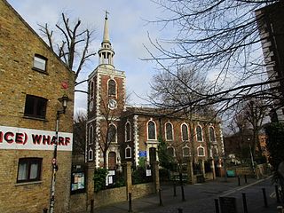
St Mary Magdalen Bermondsey is an Anglican church dedicated to St Mary Magdalen in Bermondsey in the London Borough of Southwark. The majority of the present building is late 17th century and is Grade II* listed.

Rouel Road is a street in the Bermondsey area of south London. It crosses the larger Spa Road.

West End Lane is a street in inner north-west London, England that runs for about one mile between Kilburn High Road to the south and Finchley Road to the north. Located in the London Borough of Camden, and the NW6 postal district, the street winds through West Hampstead with a mix of residential and commercial buildings. The three West Hampstead stations are all located on the road at the centre of the district of that name. In the north-east it today becomes Frognal Lane, although this stretch was once included as part of West End Lane. It also marks the western boundary of South Hampstead. It is not connected to the West End of Central London, which is around three miles to the south-east.

Maltby Street Market is a weekly street-food and provisions market in Bermondsey, southeast London, England. The market is located on a street of the same name near Tower Bridge in the old Horselydown parish of Bermondsey.
Henry Stock (1824/5–1909) was a British architect. He served as the county surveyor for Essex for nearly 50 years, and as the surveyor and architect to the Worshipful Company of Haberdashers. The latter appointment led Stock to undertake a considerable number of educational commissions, but his primary field of activity was in the construction of manufacturing sites and warehouses in London.

Mortlake High Street is a street running through Mortlake in west London in England, United Kingdom. Located in the London Borough of Richmond, it is the historic high street of Mortlake dating back several centuries. It runs from east to west, beginning at The Terrace, Barnes and running parallel to the southern bank of the River Thames and finishing at Mortlake Green close to Mortlake railway station and the site of the former Mortlake Brewery. It forms part of the A3003 road.

New End Square is a square in Hampstead, in the London Borough of Camden. It dates back to the early eighteenth century when it was located close to the Hampstead Wells spa on the adjacent Well Walk. Despite its name it is not rectangular. At its northern end is the Old White Bear pub dating back to 1704, on the corner with Well Road. Its southern end is at the junction between Flask Walk and Well Walk. New End street curls off from one corner of the square, eventually heading west to Heath Street.

Pond Street is located in Hampstead in the London Borough of Camden. It runs eastwards from Rosslyn Hill to South End Green, located in the old "South End" of the settlement. The street takes its name from an ancient pond at South End Green, a source of the River Fleet, and has been known by this name since at least 1678. The pond survived into the Victorian era.
North End Way is a street in Hampstead in the London Borough of Camden, today a stretch of the A502 road. At the boundary with the London Borough of Barnet it becomes North End Road running northwards into Golders Green where it terminates at the junction with Finchley Road, by the tube station. North End Way passes through Hampstead Heath.
St Thomas Street is a street in Southwark in London located next to London Bridge station. It takes its name from St Thomas' Hospital which was originally located nearby and dates back to the mid-sixteenth century. It runs southeastwards off Borough High Street along the southern side of Bridge station until at a junction with Bermondsey Street it becomes Crucifix Lane. The street features many historic buildings including the former St Thomas' Church, constructed in 1702, which has functioned as the Chapter House of Southwark Cathedral and part of the operating theatre of operating theatre of St Thomas' Hospital. It is now home to the Old Operating Theatre Museum and Herb Garret. The entrance to The Shard skyscraper, opened in 2012, is on St Thomas Street.

Loudoun Road is a street in the St John's Wood area of London. Most of its route is in the City of Westminster, but it crosses into the London Borough of Camden at its northern end in South Hampstead. It runs roughly parallel to Finchley Road to its east while Abbey Road, London is to the west. It runs north from Grove End Road, not far from St John's Wood tube station, and crosses or is joined by a number of streets including Marlborough Place, Carlton Hill and Boundary Road. It finishes at a roundabout junction with several streets including Belsize Road and Fairhazel Gardens. South Hampstead railway station is at the northern end of the street.

Broadhurst Gardens is a street in the London Borough of Camden running eastwards from West End Lane in West Hampstead and ending near to the Finchley Road. It forms the northern border of South Hampstead, and runs parallel to the Midland Main Line. It meets or is crossed by Priory Road, Fairhazel Gardens and Canfield Gardens.

Belsize Road is a street in the London Borough of Camden. It runs west to east from Kilburn High Road to close to Finchley Road in the Swiss Cottage area of Hampstead. It is part of the B509 route which continues eastwards as Adelaide Road to Chalk Farm tube station. Despite its name it is located to the west of Belsize Park in the South Hampstead area. Much of its route runs parallel to the Midland Main Line and Kilburn High Road station is at its eastern end. It meets a number of streets including Loudoun Road, Abbey Road and Priory Road.


