Baltic Quay

Last updated

Baltic Quay is a large residential development, located in Surrey Quays in the London Borough of Southwark. Completed in 1989 during the London Docklands Development Corporation, [1] it is largely known for its unique architecture, which won it awards from the London Docklands Development Corporation. As a result, it is considered to be a landmark development in the area.

Surrey Quays residential area of Rotherhithe in south-east London

Surrey Docks is a largely residential area of Rotherhithe in south-east London, occupied until 1970 by the Surrey Commercial Docks. The precise boundaries of the area are somewhat amorphous, but it is generally considered to comprise the southern half of the Rotherhithe peninsula from Canada Water to South Dock; electorally, Surrey Docks is the eastern half of the peninsula. The area is served by Surrey Quays railway station. The Docks are called Surrey Docks because until 1900 the borders of Surrey and Kent met in this area.

London Borough of Southwark Borough in United Kingdom

The London Borough of Southwark in South London, England forms part of Inner London and is connected by bridges across the River Thames to the City of London. It was created in 1965 when three smaller council areas amalgamated under the London Government Act 1963. All districts of the area are within the London postal district. It is governed by Southwark London Borough Council.

London Docklands Development Corporation organization

The London Docklands Development Corporation (LDDC) was a quango agency set up by the UK Government in 1981 to regenerate the depressed Docklands area of east London. During its seventeen-year existence it was responsible for regenerating an area of 8.5 square miles (22 km2) in the London Boroughs of Newham, Tower Hamlets and Southwark. LDDC helped to create Canary Wharf, Surrey Quays shopping centre, London City Airport, ExCeL Exhibition Centre, London Arena and the Docklands Light Railway, bringing more than 120,000 new jobs to the Docklands and making the area highly sought after for housing. Although initially fiercely resisted by local councils and residents, today it is generally regarded as having been a success and is now used as an exemplar of large-scale regeneration, although tensions between older and more recent residents remain.

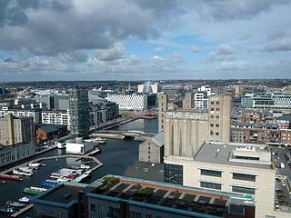
Situated between South Dock and Greenland Dock, [2] the building was originally intended for mixed use; the ground floors as commercial outlets, the 1st and 2nd floors as office space and the remaining floors as residential apartments. Notable features of the development include is its vaulted roofs, circular windows and 14-storey tower. In particular the building was known locally for its initial colour scheme of blue and yellow, leading some to dub it as the "Ikea building".

South Dock is one of two surviving docks in the former Surrey Commercial Docks in Rotherhithe, London, England. It was built in 1807–1811 just south of the larger Greenland Dock, to which it is connected by a channel now known as Greenland Cut; it also has a lock giving access to the River Thames. Originally named the East Country Dock, it was renamed in 1850 when the Surrey Commercial Dock Company purchased and enlarged it. Timber and grain were the main produce imported and exported in the dock.

Greenland Dock

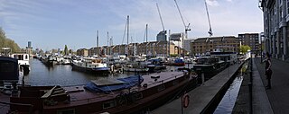
Greenland Dock is the oldest of London's riverside wet docks, located in Rotherhithe in the area of the city now known as Docklands. It used to be part of the Surrey Commercial Docks, most of which have by now been filled in. Greenland Dock is now used purely for recreational purposes; it is one of only two functioning enclosed docks on the south bank of the River Thames.

In 1995 Barlow Henley Architects were involved in the conversion of the building's office space into residential apartments. The ground floor soon followed suit as there was a lack of commercial uptake. Currently, the building is exclusively residential, [3] and is rumoured to house a High Court Judge, a Chief of Police, and retired servicemen of varying rank, most notably Admiral Henry Cuthbertson.

In April 2008, the building began phase 1 of its complete external redecoration (all elevations apart from the tower, which started and finished in 2009). This is in accordance with the lease supplied by the freeholder, which stipulates that external redecoration occurs every 10 years. This is the second external redecoration since the building's erection.

Related Research Articles

Canary Wharf major business district located in Tower Hamlets, London, United Kingdom

Canary Wharf is a commercial estate on the Isle of Dogs in London, in the London Borough of Tower Hamlets. It is one of the main financial centres of the United Kingdom, along with the City of London, and contains many of Europe's tallest buildings, including the second-tallest in the UK, One Canada Square.

Surrey Commercial Docks former group of docks in Rotherhithe, South East London, England

The Surrey Commercial Docks were a large group of docks in Rotherhithe, South East London, England, located on the south bank of the River Thames.

Docklands, Victoria Suburb of Melbourne, Victoria, Australia

Docklands is an inner-western suburb of Melbourne, Victoria, Australia, 2 km (1.2 mi) from Melbourne's Central Business District. Its local government area is the City of Melbourne. At the 2016 Census, Docklands had a population of 10,964. Docklands occupies an area adjacent to the Melbourne central business district (CBD), consisting of land and water totalling 200 hectares. It is bounded by Wurundjeri Way and the Charles Grimes Bridge to the east, CityLink to the west and Lorimer Street across the Yarra to the south and is a primarily waterfront area centred on the banks of the Yarra River.

Canada Water

Canada Water is an area of the Docklands in south-east London. It is named after a freshwater lake and wildlife refuge. Canada Water tube, Overground and bus station is immediately north of the lake, along with Canada Water Library which overhangs the lake and Deal Porter Square. Surrey Quays Shopping Centre is also adjacent, sitting immediately to the south. The surrounding area, which forms the town centre of Rotherhithe, is now increasingly known as Canada Water, after the transport interchange as much as the lake itself. The area is famous for being the terminus point for the bus route number 1.

Wood Wharf

Wood Wharf is a 23 acre site on the Isle of Dogs, London. It is currently under construction to provide offices, residential homes and retail space. The site is next to Canary Wharf. Wood Wharf will contain 5 million square feet of space, which will include 2 million sq ft of office space, 3,330 residential homes, 3.6 hectares of public spaces, and 380,000 sq ft of shops, restaurants and space for community use. It is estimated to be completed in 2023.

Columbus Tower (London)

Columbus Tower was a planned high-rise development by Commercial Estates Group approved for construction on a site on the Isle of Dogs, London Borough of Tower Hamlets. The 63-storey, 242 m (794 ft) AOD tower would have been located on a 0.36-hectare site at the western end of the north dock at West India Quay. At 2009 projected cost was £450M to build and reaching 237 metres in height, and projected was taller only by 2 m than One Canada Square.

Eastern Quay

Eastern Quay Apartments is in Royal Victoria Dock, East London

Aragon Tower

Aragon Tower on the Pepys Estate in Deptford, is one of London's tallest, privately owned residential towers at 92 metres with 29 floors. It contains 158 residential apartments ranging from 2 to 3 bedrooms, with the original floors being dual aspect maisonettes of the scissor section design.

Grand Canal Dock

Grand Canal Dock is a Southside area near the city centre of Dublin, Ireland. It is located on the border of eastern Dublin 2 and the westernmost part of Ringsend in Dublin 4, surrounding the Grand Canal Docks, an enclosed harbour where the Grand Canal comes to the River Liffey. The area has undergone significant redevelopment since 2000, as part of the Dublin Docklands area redevelopment project.

South Quay Estate

South Quay Estate is a mid-rise residential development of around 300 properties adjoining St Katharine Docks in the London Borough of Tower Hamlets. The Estate was built by the Greater London Council as a form of social housing, with the first residents moving in between 1979 and 1981. South Quay Estate includes the Burr Close, Nightingale House, St Anthony's Close and St Katharines Way developments.

Broseley Estates Limited, also referred to as Broseley Homes, was formed by Danny Horrocks after an amalgamation of developers and was controlled for most of its history by the insurance company Royal Exchange. Based in Leigh, Lancashire, Broseley were a well-respected developer building what was then, high quality and stylish homes.

Surrey Quays Shopping & Leisure is located in Rotherhithe, London. It is currently owned by British Land.

The Docklands Strategic Development Zone (SDZ) is a regeneration area in Dublin, Ireland's docklands and redundant port areas, located east of the city centre on both sides of the River Liffey in North Lotts and Grand Canal Dock.

South Quay Plaza

South Quay Plaza is a residential-led scheme under construction in Millwall on the Isle of Dogs, London, within the borough of Tower Hamlets developed by Berkeley Group Holdings and designed by architect Foster + Partners. The site of the development lies to the immediate north of Marsh Wall and to the immediate south of the financial district Canary Wharf. It is scheduled for completion in 2022.

Spire London

Spire London, previously known as Hertsmere House, is a construction project located in West India Quay, near Canary Wharf. Developed by Greenland Group and designed by HOK, the tallest building of 67 stories is set for construction by the end of 2016 with a completion target of 2020. Demolition of the current building on the site, Hertsmere House, has been completed. Piling began in January 2017 and finished in November 2017.

References

Coordinates: 51°29′35″N0°02′17″W / 51.493°N 0.038°W / 51.493; -0.038

Geographic coordinate system Coordinate system

A geographic coordinate system is a coordinate system that enables every location on Earth to be specified by a set of numbers, letters or symbols. The coordinates are often chosen such that one of the numbers represents a vertical position and two or three of the numbers represent a horizontal position; alternatively, a geographic position may be expressed in a combined three-dimensional Cartesian vector. A common choice of coordinates is latitude, longitude and elevation. To specify a location on a plane requires a map projection.