Other uses
- Marble Arch Records, a British record label
- Odeon Marble Arch, a cinema in London, UK
- Western Marble Arch Synagogue, a Jewish place of worship in central London, UK
Marble Arch is a landmark in London, UK.
Marble Arch may also refer to:

County Fermanagh is one of the thirty-two counties of Ireland, one of the nine counties of Ulster and one of the six counties of Northern Ireland.

Marble Arch is a London Underground station in the City of Westminster. The station is between Lancaster Gate and Bond Street stations on the Central line, and is in Travelcard Zone 1.

Archway is an area of north London, England, in the London Borough of Islington 3.8 miles (6 km) north of Charing Cross. It straddles the A1 and is named after a local landmark, the high, single-arched Archway Bridge which crossed the road in a cutting to the north. It has a modern commercial hub around Vantage Point and Archway tube station.

Bayswater Road is the main road running along the northern edge of Hyde Park in London. Originally part of the A40 road, it is now designated part of the A402 road.

Cuilcagh is a mountain on the border between County Fermanagh and County Cavan. With a height of 665 metres (2,182 ft) it is the highest point in both counties. It is also the 170th highest peak on the island of Ireland, and Ireland's only cross-border county top. Water from the southern slope flows underground until it emerges some miles away in the Shannon Pot, the traditional source of the River Shannon. The area is sometimes referred to as the Cuilcagh Mountains.
Florencecourt is a small village in County Fermanagh, Northern Ireland. In the 2001 Census it had a population of 135 people. It is situated within Fermanagh and Omagh district. Historically the area was called "Mullanashangan".

The Marble Arch Caves are a series of natural limestone caves located near the village of Florencecourt in County Fermanagh, Northern Ireland. The caves are named after the nearby Marble Arch, a natural limestone arch at the upstream end of Cladagh Glen under which the Cladagh River flows. The caves are formed from three rivers draining off the northern slopes of Cuilcagh mountain, which combine underground to form the Cladagh. On the surface, the river emerges from the largest karst resurgence in Ireland, and one of the largest in the United Kingdom. At 11.5 kilometres (7.1 mi) the Marble Arch Caves form the longest known cave system in Northern Ireland, and the karst is considered to be among the finest in the British Isles.
Hanging Rock is a large limestone cliff with an obtuse angle. It is located beside the village of Florencecourt in County Fermanagh, Northern Ireland, and is part of the Cuilcagh mountain region. The cliff is situated in an area dedicated The Hanging Rock Nature Reserve, which is in turn part of the Marble Arch Caves Global Geopark.

Recreational caving in the United Kingdom dates back to the mid-19th century. The four major caving areas of the United Kingdom are North Yorkshire, South Wales, Derbyshire, and the Mendips. Minor areas include Devon, North Wales, and the Scottish Highlands.
Badger Pot and Pigeon Pot are two caves found in the Karst topography on the eastern slopes of Cuilcagh Mountain, south of Florencecourt Forest Park, County Fermanagh, Northern Ireland.

The Borenore Caves, contained within the Borenore Karst Conservation Reserve, are a series of limestone caves that are located in the Central West region of New South Wales, Australia. The caves are renowned for their karst qualities, namely the numerous fossils from a long-lived reef complex from the Silurian period. Fossils include corals, crinoids, brachiopods, gastropods, pentamerids, colonial tryplasmids and trilobites. Borenore's karst is surrounded by igneous rock that flowed from volcanic eruptions at nearby Mount Canobolas.

The Cladagh River is a small river in County Fermanagh, formed from three rivers and a number of streams draining off the northern slopes of Cuilcagh mountain, which combine underground in the Marble Arch Cave system. On the surface, the River Cladagh emerges from one of the largest karst resurgences in the UK, before flowing through Cladagh Glen Nature Reserve and eventually draining into the Arney River.

The Gurgi Mosque is a mosque in Tripoli, Libya. It lies in the heart of old Tripoli as part of a complex of historic buildings. The mosque is an important tourist attraction, as is the area as a whole; nearby is the Roman Arch of Marcus Aurelius.
The Yorkshire Ramblers' Club (YRC) is the second-oldest mountaineering club in England, the oldest being the Alpine Club.

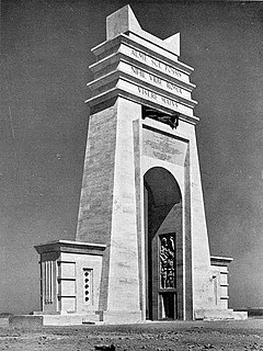
The Marble Arch, also Arch of the Philaeni, formerly known in Libya as El Gaus, was a monument in Libya built during the days of Italian colonization. The arch marked the border between Tripolitania and Cyrenaica, and was located on the Via Balbia near Ra's Lanuf.
The Caves of the Tullybrack and Belmore hills are a collection of caves in southwest County Fermanagh, Northern Ireland. The region is also described as the West Fermanagh Scarplands by environmental agencies and shares many similar karst features with the nearby Marble Arch Caves Global Geopark.

The Cuilcagh Lakelands Geopark formerly known as the Marble Arch Caves Global Geopark straddles the border between Northern Ireland and the Republic of Ireland. It is centred on the Marble Arch Caves and in 2001 it became one of the first geoparks to be designated in Europe.
Artur "Conrad" Kozłowski was a Polish cave diver who spent his last years in Ireland. Amongst other achievements in cave exploration, he set the record for the deepest cave dive in Great Britain and Ireland at a depth of 103 m (338 ft).
The Leitrim Group is a lithostratigraphical term coined to refer to the succession of rock strata which occur in Northern Ireland within the Visean and Namurian stages of the Carboniferous Period. The group disconformably overlies the Dartry Limestone of the Tyrone Group.