Bryanston Square

Last updated • 5 min readFrom Wikipedia, The Free Encyclopedia
The green centre and west, north and east facades of some of the square and the round portico cupola of the church on the horizon after the rectangle has narrowed to form Wyndham Place. Bryanston Square - geograph.org.uk - 374401.jpg
The green centre and west, north and east façades of some of the square and the round portico cupola of the church on the horizon after the rectangle has narrowed to form Wyndham Place.
A map showing the Bryanston Square ward of St Marylebone Metropolitan Borough as it appeared in 1916. St Marylebone Met. B Ward Map 1916.svg
A map showing the Bryanston Square ward of St Marylebone Metropolitan Borough as it appeared in 1916.

Bryanston Square is an 800-by-200-foot (244 by 61 m) garden square in Marylebone, London. Terraced buildings surround it often merged, converted or sub-divided, some of which remain residential. The southern end has the William Pitt Byrne memorial fountain. Next to both ends are cycle parking spaces.

Contents

The most notable merged building is the Swiss Embassy at the north-east end. The square's narrow northern and southern ends are joined by broad approach streets of the same British Regency date. More recent style flanks the mid-west range of the square in the form of No.s 31, 32 and 33 which are three times an ordinary range of its widths, meaning the numbering scheme today skips ten following numbers, destroyed to make room for these, to culminate with No.s 44 to 50 and the highest-numbered buildings of Great Cumberland Place its corner houses, No.s  63 and 68. That street, this square and Wyndham Place run broad and straight for 750 metres without building projections between an 1821-built church and Marble Arch, moved to its permanent site in 1851.

Traffic circulates clockwise around the square and numbering runs anti-clockwise.

Amenities and neighbours

Wyndham Place

Wyndham Place from the square's north end that overlaps Crawford Street Wyndham Place and St Mary's Church - geograph.org.uk - 542453.jpg
Wyndham Place from the square's north end that overlaps Crawford Street

Wyndham Place (its mainstay No.s 1 to 16) including front, railed space of its buildings forms a purposeful gap (known building line) 60 feet (18 m) across which runs north from that end of the square to become a 190-foot-wide forecourt, with seated areas, to the Church of St Mary's built in 1821 to designs by Robert Smirke. The church is Grade I listed. Its No.s 3 to 6 and 9 to 16 are alike light-brown brick terraces with white, ashlar-style stucco to the lower floors, by Parkinson, and completed by 1823, they are Grade II listed (this is the lowest and dominant of three categories). [1] [2] [3]

Great Cumberland Place

This equally broad street with parking spaces flanking runs 350 metres (1,150 ft) south. Mid-way it broadens into a green crescent, Wallenberg Place, the arc of which is fronted by five buildings including Western Marble Arch Synagogue. The thoroughfare culminates with, across an approach to Oxford Street, Marble Arch aligned just off-centre before which, flanking, are: Cumberland Court and the Cumberland Hotel which incorporates the tube station and walkway to Hyde Park. Its predominant use classes are homes and hotels.

Architectural context and features

The square, taken at its greatest, is 23 the size of Portman Square. It has roads, broad pavements and a private tree-planted garden. Wetherby Preparatory School occupies part of the south west corner. Listed are:

The neat (geometric) façades contrast with fluctuations in colour and height. Slightly varied ochre brickwork from building to building (historically referred to as 'yellow bricks') is accompanied in by differing mansard roofs, mostly of grey slate. A little facing red-brown brick is used. Decorative black balconies above the first level are accompanied by a white chamfered band course at the penultimate level before the mansard. At the divide of the mansards or parapet roofs with roof gardens is a longer such course forming a more pronounced white band course (the main cornice). All of the casements are tall white, multi-pane sash windows of uniform height and distribution. [5] [6] [7] The first-listed above was finished in 1811 to designs by Joseph Parkinson. [4] The doric and ionic orders are used but symmetry is stressed. [4] No.s  10 to 12 and 19 to 21 were rebuilt to match, due to war damage. [4]

In the south is the William Pitt Byrne Memorial Fountain, erected in 1862, a Grade II (initial category) listed monument under the statutory protection scheme, [11] as is an ornamental water pump at the opposite end. [12]

Ambassadorial presence

History

Named after its founder Henry William Portman's home village of Bryanston (as lords of the manor) in Dorset, it was built as part of the family's estate between 1810 and 1815, along with Montagu Square beyond the nominally-associated eastern Mews.

Notable people

Tributes

The Bryanston suburb of Johannesburg, South Africa, is named after the square. [16]

Notes

  1. Number 38 was demolished in 1940 due to damage during the Blitz [15]

Related Research Articles

<span class="mw-page-title-main">Albert Square, Manchester</span> Public square in Manchester, England

Albert Square is a public square in the centre of Manchester, England. It is dominated by its largest building, the Grade I listed Manchester Town Hall, a Victorian Gothic building by Alfred Waterhouse. Other smaller buildings from the same period surround it, many of which are listed.

<span class="mw-page-title-main">Bedford Square</span> Garden square in the Borough of Camden in London, England

Bedford Square is a garden square in the Bloomsbury district of the Borough of Camden in London, England.

<span class="mw-page-title-main">Richard Westmacott</span> British sculptor

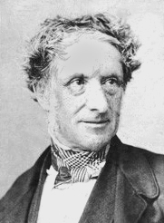
Sir Richard Westmacott was a British sculptor.

<span class="mw-page-title-main">Sunlight House</span> Building in Manchester, England

Sunlight House is a Grade II listed building in the art deco style on Quay Street in Manchester, England. Completed in 1932 for Joseph Sunlight, at 14 storeys it was the tallest building in Manchester, and the top floors of turrets and multiple dormer windows and mansard roofs create a distinctive skyline.

<span class="mw-page-title-main">Richmond Green</span> Park in Richmond, London, England

Richmond Green is a recreation area near the centre of Richmond, a town of about 20,000 inhabitants situated in south-west London. Owned by the Crown Estate, it is leased to the London Borough of Richmond upon Thames. The Green, which has been described as "one of the most beautiful urban greens surviving anywhere in England", is roughly square in shape and its open grassland, framed with broadleaf trees, extends to roughly twelve acres. On the north-east side there is also a smaller open space called Little Green. Richmond Green and Little Green are overlooked by a mixture of period townhouses, historic buildings and municipal and commercial establishments including the Richmond Lending Library and Richmond Theatre.

<span class="mw-page-title-main">Piccadilly Gardens</span> Public park in Manchester, England

Piccadilly Gardens is a green space in Manchester city centre, England, on the edge of the Northern Quarter.

<span class="mw-page-title-main">Golden Square</span>

Golden Square, in Soho, the City of Westminster, London, is a mainly hardscaped garden square planted with a few mature trees and raised borders in Central London flanked by classical office buildings. Its four approach ways are north and south but it is centred 125 metres east of Regent Street and double that NNE of Piccadilly Circus. A small block south is retail/leisure street Brewer Street. The square and its buildings have featured in many works of literature and host many media, advertising and public relations companies that characterise its neighbourhood within Soho.

<span class="mw-page-title-main">Queen Square, Bristol</span> Public square in Bristol, England

Queen Square is a 2.4 hectares Georgian square in the centre of Bristol, England. Following the 1831 riot, Queen Square declined through the latter part of the 19th century, was threatened with a main line railway station, but then bisected by a dual carriageway in the 1930s. By 1991 20,000 vehicles including scheduled buses were crossing the square every day, and over 30% of the buildings around it were vacant.

<span class="mw-page-title-main">Montagu Square</span>

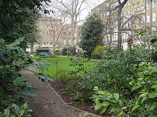
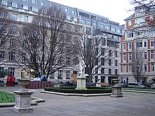
Montagu Square is a garden square in Marylebone, London. It is centred 550 metres north of Marble Arch. It spans 810 feet (250 m) by 150 feet (46 m). and is oriented on an axis of about NNW. Save for No.s 27 to 29 the long sides (NNW-SSE) are Grade II listed residential buildings.

<span class="mw-page-title-main">St Mary's, Bryanston Square</span> Church in Marylebone, London, England

St Mary's, Bryanston Square, is a Church of England church dedicated to the Virgin Mary on Wyndham Place, Bryanston Square, London. A related Church of England primary school which was founded next to it bears the same name.

<span class="mw-page-title-main">F. W. Pomeroy</span> British sculptor

Frederick William Pomeroy was a prolific British sculptor of architectural and monumental works. He became a leading sculptor in the New Sculpture movement, a group distinguished by a stylistic turn towards naturalism and for their works of architectural sculpture. Pomeroy had several significant public works in London and elsewhere in the United Kingdom, notably in Belfast. His work in London includes the figure of Lady Justice (1905–1906) on the dome of the Old Bailey.

<span class="mw-page-title-main">Woodbury County Courthouse</span> United States historic place

The Woodbury County Courthouse is located at 620 Douglas Street in Sioux City, the county seat of Woodbury County, Iowa, United States. It is regarded as "one of the finest Prairie School buildings in the United States" and has been declared a National Historic Landmark for its architecture. It is used for legal proceedings in the county.

<span class="mw-page-title-main">Cavendish Square</span> Public square in the West End of London

Cavendish Square is a public garden square in Marylebone in the West End of London. It has a double-helix underground commercial car park. Its northern road forms ends of four streets: of Wigmore Street that runs to Portman Square in the much larger Portman Estate to the west; of Harley Street which runs an alike distance; of Chandos Street which runs for one block and; of Cavendish Place which runs the same. The south side itself is modern: the rear façade and accesses to a flagship department store and office block. On the ground floors facing are Comptoir Libanais, Royal Bank of Scotland and Pret a Manger premises.

William Pitt Byrne was a British newspaper editor and proprietor of The Morning Post.

<span class="mw-page-title-main">Trevor Square</span> Neighbourhood in Knightsbridge, London

Trevor Square is an elongated garden square in Knightsbridge, London. It was designed in the 1810s chiefly by architect William Fuller Pocock, and the mid-rise, basemented houses fronting its two long sides, with slate mansard roofs are listed in the British protective and recognising scheme, and were built in the 1820s. The main stonemason employed was Lancelot Edward Wood after whom is named neighbouring street Lancelot Place.

<span class="mw-page-title-main">Grade II listed buildings in Brighton and Hove: N–O</span>

As of February 2001, there were 1,124 listed buildings with Grade II status in the English city of Brighton and Hove. The total at 2009 was similar. The city, on the English Channel coast approximately 52 miles (84 km) south of London, was formed as a unitary authority in 1997 by the merger of the neighbouring towns of Brighton and Hove. Queen Elizabeth II granted city status in 2000.

<span class="mw-page-title-main">George Street, Marylebone</span> Street in Central London

George Street is a street in Marylebone in Central London, England. Located in the City of Westminster, it runs east from Edgware Road until it reaches Marylebone High Street at its junction with Thayer Street. It crosses a number of streets including Seymour Place, Gloucester Place, Manchester Street and Baker Street.

References

  1. Historic England. "3 to 6 Wyndham Place (1066061)". National Heritage List for England . Retrieved 12 January 2020.
  2. Historic England. "94 Crawford Street and 9 to 13 Wyndham Place (1225095)". National Heritage List for England . Retrieved 12 January 2020.
  3. Historic England. "14 to 16 Wyndham Place (1357408)". National Heritage List for England . Retrieved 12 January 2020.
  4. 1 2 3 4 5 Historic England. "1-21 and 1A (1066352)". National Heritage List for England . Retrieved 12 January 2020.
  5. 1 2 Historic England. "25-26 (1066353)". National Heritage List for England . Retrieved 12 January 2020.
  6. 1 2 Historic England. "28-32 (1066354)". National Heritage List for England . Retrieved 12 January 2020.
  7. 1 2 Historic England. "44-48 (1066355)". National Heritage List for England . Retrieved 12 January 2020.
  8. Historic England. "49-50 (1066356)". National Heritage List for England . Retrieved 12 January 2020.
  9. Historic England. "57-63 odds Great Cumberland Place (1357062)". National Heritage List for England . Retrieved 12 January 2020.
  10. Historic England. "58-68 odds Great Cumberland Place (1357062)". National Heritage List for England . Retrieved 12 January 2020.
  11. "William Pitt Byrne Memorial Fountain, Paddington". British Listed Buildings Online. Retrieved 1 March 2011.
  12. Historic England. "William Pitt Byrne Memorial Fountain (1066357)". National Heritage List for England .
  13. "Shaw-Lefevre, George John (SHW849GJ)". A Cambridge Alumni Database. University of Cambridge.
  14. Maryna Fraser, ‘Bailey, Sir Abraham , first baronet (1864–1940)’, Oxford Dictionary of National Biography, Oxford University Press, Sept 2004; online edn, May 2006 accessed 25 Aug 2008
  15. "Abe Bailey Biography". Archived from the original on 7 May 2018. Retrieved 26 January 2018.
  16. "The History of Bryanston | The Heritage Portal". www.theheritageportal.co.za. Retrieved 19 June 2018.

51°31′03″N0°09′39″W / 51.51750°N 0.16083°W / 51.51750; -0.16083