
Clerkenwell is an area of central London, England.
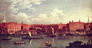
The River Fleet is the largest of London's subterranean rivers, all of which today contain foul water for treatment. It has been used as a culverted sewer since the development of Joseph Bazalgette's London sewer system in the mid-19th century with the water being treated at Beckton Sewage Treatment Works. Its headwaters are two streams on Hampstead Heath, each of which was dammed into a series of ponds—the Hampstead Ponds and the Highgate Ponds—in the 18th century. At the southern edge of Hampstead Heath these descend underground as sewers and join in Camden Town. The waters flow 4 miles (6 km) from the ponds.

The Kingsway tramway subway is a cut-and-cover tunnel in central London, built by the London County Council, and the only one of its kind in Britain. The decision in 1898 to clear slum districts in the Holborn area provided an opportunity to use the new streets for a tramway connecting the lines in the north and south. Following the pattern of tramways in New York and Boston, it was decided to build this as an underground connection.
Ermine Street is a major Roman road in England that ran from London (Londinium) to Lincoln and York (Eboracum). The Old English name was Earninga Strǣt (1012), named after a tribe called the Earningas, who inhabited a district later known as Armingford Hundred, around Arrington, Cambridgeshire, and Royston, Hertfordshire. "Armingford", and "Arrington" share the same Old English origin. The original Celtic and Roman names for the route remain unknown. It is also known as the Old North Road from London to where it joins the A1 Great North Road near Godmanchester.

Old Street is a 1-mile (1.6 km) street in inner north-east Central London, England that runs west to east from Goswell Road in Clerkenwell, in the London Borough of Islington, via St Luke's and Old Street Roundabout, to the crossroads where it meets Shoreditch High Street (south), Kingsland Road (north) and Hackney Road (east) in Shoreditch in the London Borough of Hackney.
The Metropolitan Borough of Finsbury was a metropolitan borough within the County of London from 1900 to 1965, when it was amalgamated with the Metropolitan Borough of Islington to form the London Borough of Islington.
The EC postcode area, also known as the London EC postal area, is a group of postcode districts in central London, England. It includes almost all of the City of London and parts of the London boroughs of Islington, Camden, Hackney, Tower Hamlets and Westminster. The area covered is of very high density development. Deliveries for the EC postcode area are made from Mount Pleasant Mail Centre.

Goswell Road, in Central London, is an end part of the A1. The southern part ends with one block, on the east side, in City of London; the rest is in the London Borough of Islington, the north end being Angel. It crosses Old Street/Clerkenwell Road. In the north it splits Clerkenwell from Finsbury; the south was sometimes used as a demarcator but all but the southern corporate/legal/financial end in the modern era forms the heart of the highly developed mixed-use district Barbican.

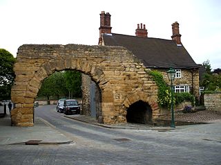
Hicks Hall, or Hickes' Hall, was a courthouse at the southern end of St John Street, Clerkenwell, London. It opened in 1612, and was closed and demolished in 1782. It was the first purpose-built sessions house for justices of the peace of the county of Middlesex, and became the main court of petty sessions and arraignment for more serious offences, including cases involving plots, attacks and minor transgressions against the state.

The West Cross Route (WCR) is a 0.75-mile-long (1.21 km) segment of dual carriageway of the A3220 route in West London running north–south between the northern elevated roundabout junction with the western end of Westway (A40) and the southern Holland Park Roundabout. It runs through Shepherd's Bush to its west and Notting Hill to its east.

St Sepulchre was an ancient parish which had its southern part within the boundaries of the City of London and its northern part outside. Its former area is now within the contemporary neighbourhoods of Smithfield, Farringdon and Clerkenwell.

St John Street is a historic street located in Clerkenwell, Islington, north London, England.
Hockley-in-the-Hole was an area of Clerkenwell Green in central London where bull-baiting, bear-baiting and similar activities occurred in the 17th and 18th centuries. The Beargarden was located at Hockley-in-the-Hole where the Coach pub is today, at the junction of Back Hill and Ray Street, north of the junction of Clerkenwell Road and Farringdon Road.

Northampton Square, a green town square, is in a corner of Clerkenwell projecting into Finsbury, in Central London. It is between Goswell Road and St John Street, has a very broad pedestrian walkway on the north-west side between university buildings and is fronted chiefly by main buildings of City, University of London.

The New Road was a toll road built across fields around the northern boundaries of London, the first part of which opened in 1756. The route comprises the modern-day A501.

St John Clerkenwell is a former parish church in Clerkenwell, London, and now the priory church of the British Crown Order of St John.

Bakers Row is a road in London which forms the gateway to a network of little cobbled streets which form part of Little Italy, a nickname which applies to the western area of Clerkenwell.

Angel is an area on the northern fringes of Central London within the London Borough of Islington. It is 2 miles (3.2 km) north-northeast of Charing Cross on the Inner Ring Road at a busy transport intersection. The area is identified in the London Plan as one of 35 major centres in London. It is a significant commercial and retail centre, and a business improvement district. Angel straddles the ancient boundary of the parishes of Clerkenwell and Islington that later became the metropolitan boroughs of Finsbury and Islington. It is named from the former Angel Inn which stood on the corner of Islington High Street and Pentonville Road. Since 1965 the whole area has formed part of the London Borough of Islington in Greater London.

Turnmill Street is a street in Clerkenwell, London. It runs north–south from Clerkenwell Road in the north, to Cowcross Street in the south. One of the oldest streets in London, it has been variously known as Turnmill and Turnbull Street over its history. During the Elizabethan era, under the name Turnbull Street it became "the most disreputable street in London", notorious as a centre of crime and prostitution.

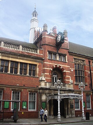
Rosebery Avenue is a major thoroughfare in the boroughs of Camden and Islington, Central London. It starts southwest from the intersection with Theobald's Road, Holborn, and ends northeast at St John Street, Clerkenwell. Finsbury Town Hall and Charles Rowan House are among properties located on this road.

