Related Research Articles

Clerkenwell is an area of central London, England.
The River Fleet is the largest of London's subterranean rivers, all of which today contain foul water for treatment. It has been used as a culverted sewer since the development of Joseph Bazalgette's London sewer system in the mid-19th century with the water being treated at Beckton Sewage Treatment Works. Its headwaters are two streams on Hampstead Heath, each of which was dammed into a series of ponds—the Hampstead Ponds and the Highgate Ponds—in the 18th century. At the southern edge of Hampstead Heath these descend underground as sewers and join in Camden Town. The waters flow 4 miles (6 km) from the ponds.

Bull-baiting is a blood sport involving pitting a bull against dogs with the aim of attacking and subduing the bull by biting and holding onto its nose or neck, which often resulted in the death of the bull.

Islington was a civil parish and metropolitan borough in London, England. It was an ancient parish within the county of Middlesex, and formed part of The Metropolis from 1855. The parish was transferred to the County of London in 1889 and became a metropolitan borough in 1900. It was amalgamated with the Metropolitan Borough of Finsbury to form the London Borough of Islington in Greater London in 1965.

Hatton Garden is a street and commercial zone in the Holborn district of the London Borough of Camden, abutting the narrow precinct of Saffron Hill which then abuts the City of London. It takes its name from Sir Christopher Hatton, a favourite of Queen Elizabeth I, who established a mansion here and gained possession of the garden and orchard of Ely Place, the London seat of the Bishops of Ely. It remained in the Hatton family and was built up as a stylish residential development in the reign of King Charles II. For some decades it often went, outside of the main street, by an alternative name St Alban's Holborn, after the local church built in 1861.

Farringdon Road is a road in Clerkenwell, London.

The New North Road is a road in northern central London, forming part of a link road from the A1 at Highbury into the City of London at Moorgate. It is 0.8 miles (1.3 km) in length and is part of the A1200. This link road consists of Canonbury Road and New North Road, before several smaller sections to the south leading into the city.

The A419 road is a primary route between Chiseldon near Swindon at junction 15 of the M4 with the A346 road, and Whitminster in Gloucestershire, England near the M5 motorway. The A419 is managed and maintained by a private company, Road Management Group, on behalf of the UK Department for Transport.

Goswell Road, in Central London, is an end part of the A1. The southern part ends with one block, on the east side, in City of London; the rest is in the London Borough of Islington, the north end being Angel. It crosses Old Street/Clerkenwell Road. In the north it splits Clerkenwell from Finsbury; the south was sometimes used as a demarcator but all but the southern corporate/legal/financial end in the modern era forms the heart of the highly developed mixed-use district Barbican.

Ossulstone is an obsolete subdivision (hundred) covering 26.4% of – and the most metropolitan part – of the historic county of Middlesex, England. It surrounded but did not include the City of London and the area has been entirely absorbed by the growth of London. It now corresponds to the seven London Boroughs of Inner London north of the Thames and, from Outer London, in decreasing order, certain historic parishes of the London boroughs of Ealing, Brent, Barnet, and Haringey.

Hicks Hall, or Hickes' Hall, was a courthouse at the southern end of St John Street, Clerkenwell, London. It opened in 1612, and was closed and demolished in 1782. It was the first purpose-built sessions house for justices of the peace of the county of Middlesex, and became the main court of petty sessions and arraignment for more serious offences, including cases involving plots, attacks and minor transgressions against the state.

St John Street is a historic street located in Clerkenwell, Islington, north London, England.
The A307 road runs 13.2 miles (21.2 km) through SW London and NW Surrey. It is primary at the north-east end; the remainder is non-primary, generally superseded in the mid-twentieth century in two stages by newer alignments of the Portsmouth Road, the Kingston bypass and Esher bypass of the A3, which runs along a slightly oblique axis.
The Hope Theatre was one of the theatres built in and around London for the presentation of plays in English Renaissance theatre, comparable to the Globe, the Curtain, the Swan, and other famous theatres of the era.

Northampton Square, a green town square, is in a corner of Clerkenwell projecting into Finsbury, in Central London. It is between Goswell Road and St John Street, has a very broad pedestrian walkway on the north-west side between university buildings and is fronted chiefly by main buildings of City, University of London.
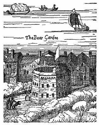
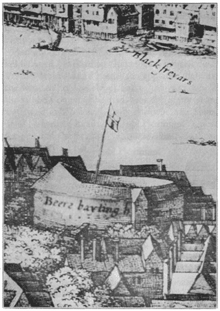
The Beargarden was a facility for bear-baiting, bull-baiting, and other "animal sports" in the London area during the 16th and 17th centuries, from the Elizabethan era to the English Restoration period. Baiting is a blood sport where an animal is tormented or attacked by another animal, often dogs, for the purpose of entertainment or gambling. Samuel Pepys visited the venue in 1666 and described it as "a rude and nasty pleasure". The last recorded event at the Beargarden was the baiting of "a fine but vicious horse" in 1682.

St John Clerkenwell is a former parish church in Clerkenwell, London, and now the priory church of the British Crown Order of St John.

Redcliffe Gardens is a primary road, the A3220 located in the Chelsea area of southwest central London, England. It was a development dated from 1864 to 1878.
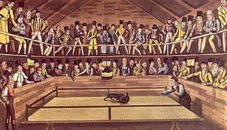
The Westminster Pit was a well-known blood sport arena in nineteenth-century London, England. It reached a zenith of popularity between 1820 and 1830, and hosted such spectacles as dog-fighting, cock-fighting, bear-baiting, badger-baiting, monkey-baiting, and rat-baiting. A legal enterprise at the time, the Westminster Pit openly declared its activities, ushering notoriety on the district in which it existed.

Clerkenwell Road is a street in London.
References
- ↑ A Topographical Dictionary of England: Clerkenwell
- ↑ Old and New London: Volume 2 - Clerkenwell (Part 1)
- ↑ Old and New London: Volume 2 - Clerkenwell (Part 2)
- 1 2 "Hockley-in-the-Hole | British History Online". www.british-history.ac.uk.
- ↑ Boulton, W. 1901. The Amusements of Old London: CHAPTER I - THE DIVERSIONS OF HOCKLEY IN THE HOLE, AND AT FIGG'S. ISBN 9781139094375
51°31′23″N0°6′30″W / 51.52306°N 0.10833°W
| | This London location article is a stub. You can help Wikipedia by expanding it. |
| | This article about a London sports venue is a stub. You can help Wikipedia by expanding it. |