West Hurley is a hamlet in Ulster County, New York, United States. The population was 1,917 at the 2020 census.

Marylebone Road is an important thoroughfare in central London, within the City of Westminster. It runs east–west from the Euston Road at Regent's Park to the A40 Westway at Paddington. The road which runs in three lanes in both directions, is part of the London Inner Ring Road and as such forms part of the boundary of the zone within which the London congestion charge applies.

The M23 is a motorway in the United Kingdom, running from the south of Hooley in Surrey, where it splits from the A23, to Pease Pottage, south of Crawley in West Sussex where it rejoins the A23. The northern end of the motorway starts on what is effectively a 2-mile (3.2 km) spur north of junction 7 of the M25 motorway. From Hooley it runs for 17 miles (27 km) past Redhill, Gatwick Airport and Crawley. A spur runs from junction 9 to Gatwick Airport.

The Abitibi River is a river in northeastern Ontario, Canada, which flows northwest from Lake Abitibi to join the Moose River which empties into James Bay. This river is 540 kilometres (340 mi) long, and descends 265 metres (869 ft). It is the ninth longest river in Ontario, Behind the Ottawa River (1,271km), St. Lawrence River (1.197km), Severn River (982km), Albany River (982km), Winnipeg River (813km), Attawapiskat River (748km), English River (615km) and Moose River(547km).
The EC postcode area, also known as the London EC postal area, is a group of postcode districts in central London, England. It includes almost all of the City of London and parts of the London boroughs of Islington, Camden, Hackney, Tower Hamlets and Westminster. The area covered is of very high density development. Deliveries for the EC postcode area are made from Mount Pleasant Mail Centre.
St Martin's Lane is a street in the City of Westminster, which runs from the church of St Martin-in-the-Fields, after which it is named, near Trafalgar Square northwards to Long Acre. At its northern end, it becomes Monmouth Street. St Martin's Lane and Monmouth Street together form the B404.

York Road is a football stadium in Maidenhead, Berkshire, England. The home ground of Maidenhead United, it is acknowledged by The Football Association and FIFA to be the oldest continuously-used senior association football ground in the world by the same club, having been home to the club since 1871. A blue plaque commemorating this is placed just inside the home turnstiles on the York Road side of the ground.

The Bristol and Bath Railway Path is a 15-mile (24 km) off-road cycleway, part of National Cycle Network National Cycle Route 4. It has a 3-metre (9.8 ft) wide tarmacked surface, and was used for 2.4 million trips in 2007, increasing by 10% per year.
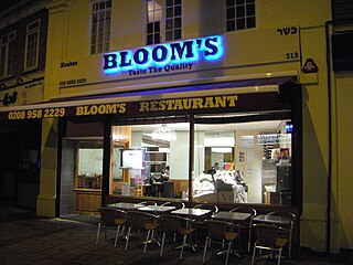
Bloom's restaurant was a kosher Jewish deli restaurant in London. Until its last branch closed in summer 2010, it was the longest-standing kosher restaurant in England, and was well-known beyond the Jewish community. Blooms was under the supervision of the London Beth Din.
There are several long-established Nordic churches in London. All seek to provide Lutheran Christian worship and pastoral care to their respective national communities in their own languages. Many of the churches also organise language classes and organise a wide range of social activities.
Hanbury Street is a street running from Commercial Street in Spitalfields to the junction of Old Montague Street and Vallance Road in Whitechapel located in the London Borough of Tower Hamlets. The eastern section is restricted to pedal cycles and pedestrians only.

Brickfields Meadow is a meadow in Woodside in the London Borough of Croydon. It is located on the former site of a brickworks in Tennison Road and Dickensons Lane. The meadow covers an area of about 4.37 hectares. The meadow is not very well known to residents on Tennison Road, as the entrance is very secluded, beyond an EDF Energy transformer. The meadow includes: large pond where fishing is allowed, dipping platform, Buddleia Valley, grassland and woodland planting, small woodland area, and a children's play area which includes a mini maze and roundabout.

Mendota Township is located in LaSalle County, Illinois, United States. As of the 2010 census, its population was 7,534 and it contained 3,111 housing units. Mendota Township was formed from Meriden Township in February, 1856.

Church Island or Church Eyot is an inhabited island in the River Thames in England on the reach above Penton Hook Lock in Staines-upon-Thames, Spelthorne, Surrey. It is in the upper part of the reach. It is approximately 200 m (660 ft) above Staines Bridge, but is thought by some historians to have been the site of the Roman bridges (Pontes) across the Thames recorded as a waypoint on the Devil's Highway between Londinium (London) and Calleva (Silchester).

Galvin at Windows is a restaurant located on the top floor of the London Hilton on Park Lane restaurant. Launched in May 2006 by Chef Patron Chris Galvin as the second restaurant from the Galvin Brothers, the restaurant was awarded its Michelin Star in 2007 and maintained it until 2020 when they lost the single star.
Cheyenne South High School is a public secondary school located in Cheyenne, Wyoming, United States. It serves Laramie County School District #1.
The metropolitan area of London, England, United Kingdom, is served by six international airports and several smaller airports. Together, these airports constitute the busiest airport system in the world by passenger numbers and the second-busiest by aircraft movements. In 2018, the six airports handled a total of 177,054,819 passengers. The London airports handle over 60% of all the UK's air traffic. The airports serve a total of 14 domestic destinations and 396 international destinations.
The Subway Gallery was a contemporary art gallery in the West End of London, England. It is now permanently closed.
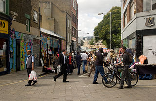
Brick Lane Market is the collective name for a number of London markets centred on Brick Lane, in Tower Hamlets in east London. The original market was located at the northern end of Brick Lane and in the heart of what is now east London's Bangladeshi community but now commonly refers to the various markets that are housed along the famous London street. The various markets that stretch the length of Brick Lane operate both weekdays but most historically weekends: Saturday from 11 a.m. to 6 p.m. and Sunday from 10 a.m. to 6 p.m.

Awutu Senya East Municipal District is one of the twenty-two districts in Central Region, Ghana. Originally it was formerly part of the then-larger Awutu Senya District on 29 February 2008, until the eastern part of the district was split off to create Awutu Senya East District on 28 June 2012, which it was later elevated to municipal district assembly status on 15 March 2018 to become Awutu Senya East Municipal District; thus the remaining part has been renamed as Awutu Senya West District. The municipality is located in the southeast part of Central Region and has Kasoa as its capital town.