Royston, South Yorkshire

Last updated

Royston
StJohnsRoyston.jpg
Parish Church of St John the Baptist
South Yorkshire UK location map.svg
Red pog.svg
Royston
Location within South Yorkshire
Population10,728 (2011 census) [1]
OS grid reference SE3511
Metropolitan borough
Metropolitan county
Region
Country England
Sovereign state United Kingdom
Post town BARNSLEY
Postcode district S71
Dialling code 01226
Police South Yorkshire
Fire South Yorkshire
Ambulance Yorkshire
UK Parliament
List of places
UK
England
Yorkshire
53°37′N1°27′W / 53.61°N 1.45°W / 53.61; -1.45 Coordinates: 53°37′N1°27′W / 53.61°N 1.45°W / 53.61; -1.45

Royston is a suburban village within the Metropolitan borough of Barnsley, in South Yorkshire, England. Historically, the village formed part of the West Riding of Yorkshire, but was incorporated into the Metropolitan borough of Barnsley in 1974 and is now on the border with West Yorkshire. It is part of the Barnsley Central borough constituency, and has a population of 10,728. [1] It is situated 4 miles (6.4 km) north-east of Barnsley, and 6 miles (9.7 km) south-east of Wakefield. [2]

Contents

History

The village is recorded in the Domesday Book as Rorestone [3] with the name deriving from Hror's or Roarr's farm /settlement (Hror/Roarr-s-tun). [4] The village was in the wapentake of Staincross. [5]

Originally a farming village, Royston joined the Industrial Revolution with the construction in the 1790s of the Barnsley Canal, and later a branch of the Midland Railway. [6] Both are now disused.

Royston had a colliery called Monckton Colliery (1878–1966).This was replaced by Royston Drift Mine. There was also, a clay works and brick works but these are all now closed, although a coke works operated until recently on the mine site processing coal brought in by road. Royston Drift Mine opened in 1975 and closed (after a relatively short period in coal mining terms) 14 years later in 1989. [7] The site is now the site of Rabbit Ings Country Park, which is now home to all five species of owls to be found in Britain. [8]

A large shirt factory with the brandname Valusta provided local employment from the 1940s through to the 1980s. Burberrys also had a factory on Midland Road

Geography

Royston lies on the Barnsley Canal, [9] and on the intersection of the B6132 and B6428 roads, due north of Monk Bretton at an elevation of around 246 feet (75 m) above sea level. The Trans Pennine Trail runs through Royston along the canal bank. [10] The parish is part of the diocese of Leeds. [11]

Landmarks

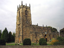
The churches in Royston include the Anglican parish church of St John the Baptist, Bethel Church, the Royston Methodist Church, and Our Lady and St Joseph, a Roman Catholic church.

The parish church of St John the Baptist was built about the year 1234 and has a clock, a sundial, a ring of eight bells and is now grade I listed. [12] [13] The church is a notable location in Royston as it is one of a few churches in England with an oriel window, and was used a navigational landmark for guiding travellers. [14]

Notable people

Harry “Shake” Earnshaw was a miner turned racing cyclist who in 1938 was acclaimed the British Best All-Rounder. [15] The comedian Charlie Williams was born in Royston in 1927. He played football for Doncaster Rovers and later found fame as one of the comedians on the TV programme The Comedians . [16]

The mountaineer Andy Cave originates from Royston, and was a coal miner until the 1984–85 miners' strike, at which point he dedicated himself to mountaineering. [17] He is also notable for his research into the dialect of Yorkshire pit villages. His 2001 doctorate stated that Royston had a slightly different accent to the surrounding villages, as many of the miners who came to work at Monckton Colliery on its opening travelled from the Black Country, where several mines had closed. [18] This hypothesis was later tested by Kate Burland, who analysed certain vowel sounds in Royston, Wakefield and Barnsley. She found that Wakefield and Barnsley residents had very similar pronunciations for the sounds under consideration, whereas Royston residents had different pronunciations that were more similar to those associated with the Midlands. [19] Yorkshire cricketer Norman Yardley lived in Royston at the Grove, which is now owned by Barnsley Metropolitan Borough Council.

Football player and manager Ernie Morgan was born in Royston. [20]

See also

Related Research Articles

<span class="mw-page-title-main">Walton, Wakefield</span> Human settlement in England

Walton is a village and civil parish in the City of Wakefield in the county of West Yorkshire, England, 3.5 miles south-east of Wakefield. At the time of the 2011 Census, the parish had a population of 3,231. At the time of the 2011 Census the parish was part of the City of Wakefield's ward of Crofton, Ryhill and Walton. The population of this ward at the Census was 15,144.

<span class="mw-page-title-main">Barnsley</span> Town in South Yorkshire, England

Barnsley is a market town in South Yorkshire, England. It is the main settlement of the Metropolitan Borough of Barnsley and the fourth largest settlement in South Yorkshire. The town's population was 96,888 in 2021, while the wider borough had a population of 244,600 in the 2021 census.

<span class="mw-page-title-main">Woolley Colliery</span> Village in South Yorkshire, England

Woolley Colliery is a village on the border between the Barnsley and Wakefield districts in Yorkshire, England. The village is now in South Yorkshire, while the former colliery was in the Wakefield Rural Ward in West Yorkshire. The village is known locally as Mucky Woolley, as a tribute to its coalmining heritage and to distinguish it from the more affluent village of Woolley two miles away.

<span class="mw-page-title-main">Worsbrough</span> Area in South Yorkshire, England

Worsbrough is an area about two miles south of Barnsley in the metropolitan borough of Barnsley, South Yorkshire, England. Before 1974, Worsbrough had its own urban district council in the West Riding of the historic county of Yorkshire and it is still counted as a separate place from Barnsley by the 2011 Census, but it is often treated as part of Barnsley as the two settlements run into one another.

<span class="mw-page-title-main">Cudworth, South Yorkshire</span> Village in South Yorkshire, England

Cudworth is an urban village approximately 3.5 miles (5.6 km) north-east of Barnsley transport interchange in South Yorkshire, England. Historically within the West Riding of Yorkshire, Cudworth has a busy shopping area along the Barnsley to Pontefract Road which serves a local population of 10,977.

<span class="mw-page-title-main">Elsecar</span> Village in South Yorkshire, England

Elsecar is a village in the Metropolitan Borough of Barnsley in South Yorkshire, England. It is near to Jump and Wentworth, it is also 2 miles (3.2 km) south of Hoyland, 6 miles (9.7 km) south of Barnsley and 8 miles (13 km) north-east of Sheffield. Elsecar falls within the Barnsley Metropolitan Borough Ward of Hoyland Milton.

<span class="mw-page-title-main">Hemsworth (UK Parliament constituency)</span> Parliamentary constituency in the United Kingdom

Hemsworth is a constituency in West Yorkshire represented in the House of Commons since 1996 by Jon Trickett of the Labour Party.

<span class="mw-page-title-main">Wath upon Dearne</span> Town in South Yorkshire, England

Wath upon Dearne is a town south of the River Dearne in the Metropolitan Borough of Rotherham, South Yorkshire, England, 5 miles (8 km) north of Rotherham and almost midway between Barnsley and Doncaster. It had a population of 11,816 at the 2011 census. It is twinned with Saint-Jean-de-Bournay in France.

<span class="mw-page-title-main">Netherton, Wakefield</span> Human settlement in England

Netherton is a village in the City of Wakefield metropolitan borough of West Yorkshire, England. It lies about 4 miles south-west of Wakefield, 3 miles south of Ossett, 1 mile south of Horbury. The village is in the Wakefield Rural ward of Wakefield Metropolitan District Council. The village name is shown on map "Dvcatvs Eboracensis pars occidentalis" from 1646.

<span class="mw-page-title-main">Staincross Wapentake</span> Former division of the West Riding of Yorkshire, England

Staincross was a Wapentake (Hundred), which is an administrative division, in the historic county of the West Riding of Yorkshire. It consisted of seven parishes, and included the towns of Barnsley and Penistone

<span class="mw-page-title-main">Ryhill</span> Village and civil parish in West Yorkshire, England

Ryhill is a small village and civil parish situated on the B6428 road in West Yorkshire, England approximately 7 miles (11 km) south-east of the city of Wakefield. It has a population of 2,628, increasing to 2,894 at the 2011 census.

<span class="mw-page-title-main">Barnsley Coal Railway</span>

The Barnsley Coal Railway was a short railway which, when fully opened, ran between Stairfoot Junction, on the Mexborough to Barnsley line of the South Yorkshire Railway (SYR) and a triangular junction at Nostell on the line of the West Riding and Grimsby Railway (WR&GR).

<span class="mw-page-title-main">Staincross and Mapplewell railway station</span> Former railway station in England

Staincross and Mapplewell railway station was one of three stations built on the Barnsley Coal Railway and opened when that line was completed in 1882. The station was situated adjacent to the main Wakefield road (A61), slightly to the east of Staincross, on the edge of the present day Athersley estate. It was about 1 mile east of Mapplewell. The station was situated between Stairfoot and Notton and Royston.

The South Yorkshire Coalfield is so named from its position within Yorkshire. It covers most of South Yorkshire, West Yorkshire and a small part of North Yorkshire. The exposed coalfield outcrops in the Pennine foothills and dips under Permian rocks in the east. Its most famous coal seam is the Barnsley Bed. Coal has been mined from shallow seams and outcrops since medieval times and possibly earlier.

<span class="mw-page-title-main">Notton and Royston railway station</span> Former railway station in England

Notton and Royston railway station was a railway station that served the village of Royston, South Yorkshire, England. It was situated on the Barnsley Coal Railway between Staincross and Mapplewell and Ryhill.

<span class="mw-page-title-main">Wharncliffe Woodmoor 1, 2 & 3 Colliery</span> Former coal mine in South Yorkshire, England

Wharncliffe Woodmoor 1, 2 and 3 colliery was a coal mine that was located at the junction of Laithes Lane and Carlton Road, about 2 miles (3.2 km) north-east of Barnsley, South Yorkshire and a quarter mile east of Staincross and Mapplewell railway station, on the Great Central Railway. The branch line junction was about 200 feet (61 m) from Staincross that connected it to the colliery via a private line. The line finished up between the three main shafts and the coking ovens.

<span class="mw-page-title-main">Smithies, South Yorkshire</span> Area of Barnsley, South Yorkshire, England

Smithies is an area of Barnsley in South Yorkshire, England. It lies about two miles north-east of the town centre.

Barrow Colliery was a coal mine in Worsborough, South Yorkshire, England. It was first dug in 1873, with the first coal being brought to the surface in January 1876. It was the scene of a major incident in 1907 when seven miners died. After 109 years of coaling operations, the mine was closed in May 1985.

<span class="mw-page-title-main">Monckton Coke Works</span> Former coking plant in South Yorkshire, England

Monckton Coke Works was a coking plant near Royston in South Yorkshire, England. The plant opened in 1884 and was closed 130 years later in 2014, being one of the last remnants of the coal industry in Yorkshire. In the 21st century, it was known as being the last independent coke works in the United Kingdom. For many years it was known for its high-quality coking coal, even being exported to coal-rich South Africa for use in steelmaking. However, in 2013/2014, the market was swamped with cheap imports from the Far East, spelling the demise of Monckton due to it being uneconomical.

Upton Colliery was a coal mine near to the village of Upton in the West Riding of Yorkshire, England. The site was 8.5 miles (13.7 km) north west of Doncaster and 10 miles (16 km) north east of Barnsley. Coal was transhipped from the colliery by the former Hull and Barnsley Railway line.

References

  1. 1 2 UK Census (2011). "Local Area Report – Royston Ward (as of 2011) (E05000992)". Nomis. Office for National Statistics . Retrieved 12 December 2019.
  2. "Genuki: ROYSTON: Geographical and Historical information from the year 1868., Yorkshire (West Riding)". www.genuki.org.uk. Retrieved 12 December 2019.
  3. "Royston | Domesday Book". opendomesday.org. Retrieved 12 December 2019.
  4. Ekwall, Eilert (1960). The concise Oxford dictionary of English place-names (4 ed.). Oxford: Oxford University Press. p. 395. ISBN   0-19-869103-3.
  5. Smith, Albert H. (1961). he place-names of the West Riding of Yorkshire; 1. Lower & Upper Strafforth and Staincross Wapentakes. Cambridge: Cambridge University Press. p. 285. OCLC   174292315.
  6. "Roydon – Rudyard | British History Online". www.british-history.ac.uk. Retrieved 12 December 2019.
  7. "Barnsley Coalfield". nmrs.org.uk. Retrieved 12 December 2019.
  8. "Former pit home to five owl species". BBC News. 19 March 2013. Retrieved 12 December 2019.
  9. Glister, Roger (2004). The forgotten canals of Yorkshire : Wakefield to Swinton via Barnsley. The Barnsley and Dearne & Dove canals. Barnsley: Wharncliffe. p. 16. ISBN   1-903425-38-7.
  10. "Trail Trips – Old Moor to Old Royston" (PDF). transpenninetrail.org.uk/leaflet-downloads/. Retrieved 12 December 2019.
  11. "OVER-VIEW FOR THE UNITED BENEFICE OF ROYSTON ST THE JOHN BAPTIST AND FELKIRK ST PETER'S" (PDF). leeds.anglican.org. p. 3. Retrieved 12 December 2019.
  12. Historic England. "Church of St John The Baptist (Grade I) (1151127)". National Heritage List for England . Retrieved 12 December 2019.
  13. Pevsner, Nikolaus (2001). Yorkshire : the West Riding (2 ed.). London: Penguin Books. p. 424. ISBN   0-14-071017-5.
  14. "St John the Baptist, Church Street". historicengland.org.uk. Historic England. Retrieved 12 December 2019.
  15. "Historic Rose Bowl is unearthed – Barnsley News from the Barnsley Chronicle". Barnsley Chronicle. 8 June 2018. Retrieved 12 December 2019.
  16. Vamplew, Wray. "Williams, Charles Adolphus [Charlie]". Oxford Dictionary of National Biography (online ed.). Oxford University Press. doi:10.1093/ref:odnb/97423.(Subscription or UK public library membership required.)
  17. Cave, Andy (2006). Learning to breathe. London: Arrow. pp. x–xiv. ISBN   9780099472667.
  18. Cave, Andrew (2001). "Language variety and communicative style as local and subcultural identity in a South Yorkshire coal mining community". The University of Sheffield. Retrieved 21 July 2013.
  19. Burland, Kate (2017). "11: Where the black country meets 'black Barnsley': dialect variation and identity in an ex-mining community of Barnsley". In Montgomery, Chris; Moore, Emma (eds.). Language and a sense of place : studies in language and region. Cambridge: Cambridge University Press. pp. 234–257. ISBN   9781107098718.
  20. Triggs, Roger (2001). The Men Who Made Gillingham Football Club. Tempus Publishing Ltd. p. 226. ISBN   0-7524-2243-X.