Monk Bretton

Last updated

Monk Bretton
Monk Bretton High street top.JPG
View of Monk Bretton High Street, featuring the ancient Butter Cross
South Yorkshire UK location map.svg
Red pog.svg
Monk Bretton
Location within South Yorkshire
OS grid reference SK5198
Metropolitan borough
Metropolitan county
Region
Country England
Sovereign state United Kingdom
Post town BARNSLEY
Postcode district S71
Dialling code 01226
Police South Yorkshire
Fire South Yorkshire
Ambulance Yorkshire
UK Parliament
List of places
UK
England
Yorkshire
53°34′42″N1°24′54″W / 53.5784°N 1.4149°W / 53.5784; -1.4149

Monk Bretton is a village in the Metropolitan Borough of Barnsley in South Yorkshire, England. It lies approximately two miles north-east from Barnsley town centre. Until 1974 it was in the West Riding of Yorkshire.

Contents

History

Monk Bretton has been a settlement since medieval times and was originally known as just 'Bretton'. It is sometimes thought to have taken its name from the twelfth-century Adam fitz Swain de Bretton, whose family owned much land in the area and who also founded Monk Bretton Priory. [1] However, in the Domesday Book of 1086 the area is already known as Brettone, and the name may have originally meant 'Farmstead of the Britons', suggesting that a remnant of the old Romano-British population may have lived here into the Anglo-Saxon period. According to Domesday Book, the local Saxon lord in 1066 had been an individual called Wulfmer, who by 1086 had been replaced by a Norman lord, Illbert de Lacey, [2] a major landholder associated with many other locations in the county. [3] By 1225 the village was referred to as Munkebretton, ‘munke’ referring to the monks of the nearby Priory. [4]

In 1444, Sir William de Bretton gave to Thomas Haryngton, esquire, and other trustees, lands and tenements in Monk Bretton, which his father and grandfather had leased to the prior and convent for a term of years. [5]

The mediaeval village cross, today known as the ‘Butter Cross’, still survives, standing at the junction of High Street and Cross Street. This precious monument had the go ahead for a traffic island to protect it in 2011. The scheme, costing £106,000 also saw the road junction widened for buses and other large vehicles to pass on the correct side of the road rather than the opposite as in previous years. The cross may have had a social as well as a religious function, a place to meet and hear news. [6] The village park also shows traces of mediaeval ridge and furrow cultivation. [7]

The Manor of Wakefield Act 1609 (7 Jas. 1. c. 1) gave all freeholders of Monk Bretton manorial rights and, since it was not repealed, technically everyone who owns freehold property or land is a 'lord' of the manor. [6]

On Burton Bank is a Quaker burial ground dating from the 1650s. The land was donated by a local benefactor, George Ellis, and the first recorded burial on the site took place in 1657. [8] Later a small meeting house was erected, which became a focus for local Quakers up until the 19th century. [6] An almshouse was founded in 1654 by a Dame Mary Talbot and was still in existence 180 years later. [9]

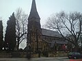
Although the nearby Priory formed a Christian community (until dissolution by Henry VIII), Monk Bretton did not possess a church until 1838. The village formed part of the extensive parish of Royston. In 1838 the foundation stone for the first church was laid on a site donated by Sir George Wombwell, at the corner of Cross Street and Burton Road. A new chapelry district, separating Monk Bretton (with Cudworth) from Royston parish and enabling 'baptisms, churchings and burials', was created by Queen Victoria by an order in Council on 22 July 1843. [10] The first church was replaced (on the same site) by the present St Paul's Church in 1878. [11] The church, built in the late Decorated style, is now a grade II listed building. [12] The churchyard contains 16 burials from the 1866 Oaks Colliery explosion.

In 1801, Monk Bretton had a population of 480. [13] By the 1870s, this had grown to just over 1900, according to John Marius Wilson's Imperial Gazetteer of England and Wales 1870–72. Wilson also stated that besides its church, Monk Bretton had three Methodist chapels, as well as a national school and six alms-houses. [14]

NCB Monk Bretton Colliery Tag NCBMonkBrettonCollieryTag.jpg
NCB Monk Bretton Colliery Tag

Monk Bretton Colliery opened in 1870, extracting coal from the Barnsley Seam. The colliery was modernised on nationalisation and pit head baths, which still stand today, were opened. A village Miners' Welfare Hall was opened in Cross Street. The colliery was closed in 1968. [11]

In February 1888 Monk Bretton was the location of a notorious murder, when the local doctor, William Burke, shot dead his own nine-year-old daughter Aileen Burke in the Norman Inn before attempting suicide with the same weapon. Despite shooting himself in the chest, Burke survived and was convicted of murder. He was sentenced to death but the sentence was later commuted. However, Burke subsequently died in prison in May 1889. [15]

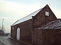
Monk Bretton once possessed some of the most historic buildings in the Barnsley area, but these were never preserved. [11] The Manor House and several other interesting structures on Cross Street and High Street disappeared in the 1960s. [6] Also demolished was Monk Bretton 'Castle', a folly on Burton Bank built by a local priest as a look-out tower or observatory and subsequently used for the lighting of beacons on occasions such as royal events and the end of wars. [6] Only Manor Farm remains, and the oldest structure still standing is a 17th-century barn at the junction of Cross Street and Westgate, belonging to the farm. [11] The village greatly expanded in the 19th and 20th centuries with the building of new housing estates, so that today Monk Bretton more or less merges into nearby Lundwood, Carlton, Athersley and Smithies.

Monk Bretton was formerly a township and chapelry in the parish of Roystone, [16] in 1866 Monk Bretton became a separate civil parish, on 1 April 1921 the parish was abolished and merged with Barnsley. [17] In 1921 the parish had a population of 5135. [18] From 1894 to 1921 Monk Bretton was an urban district that contained the parish. [19] It is now in the unparished area of Barnsley.

Transport and amenities

The village is served by several pubs, shops, a post office, library and various other local amenities, and is a 10-minute car journey from Barnsley town centre. A Stagecoach bus service connects the village with Barnsley Interchange. The railway station closed in 1937, though the railway remains in place serving a glass works.

Sites of interest

St Paul's Church The Village Church.JPG
St Paul's Church

There is a disused former Quaker burial ground, a site described by Barnsley historian Brian Elliott as being 'of regional and national importance, as one of the earliest Quaker burial grounds in the country'. [20] There is also a modern cemetery, which contains the grave of former Barnsley, Manchester United and England striker Tommy Taylor, who was killed in the Munich air disaster on 6 February 1958. He was born in Barnsley on 29 January 1932 and lived in the town until he joined Manchester United in 1953.

The nearby Priory of St Mary Magdalene of Lund, a ruined former Cluniac (later Benedictine) house, is commonly known as Monk Bretton Priory although it actually lies outside the modern village in what is today called Lundwood and close to the old hamlet of Littleworth. The Priory, Littleworth and the village were all constituent parts of the manor of Monk Bretton.

The Ardagh Glass plant, previously Redfearns Glass, lies at the edge of the village and was formerly the largest glassworks in Europe. It keeps alive Barnsley's glassmaking tradition, represented by a glassblower on the Barnsley coat of arms.

A war memorial stands on Cross Street, consisting of a paved area and two large pillars bearing the names of Monk Bretton's war dead from the Great War.

Monk Bretton has an 8.7 acre park featuring a wildlife pond. [7] The site shows undulations indicative of ridge and furrow cultivation. [7] The Monk Bretton Miners' Welfare Committee was granted £4,760 in 1925 for the purpose of purchasing the former farmland for recreational use. In 1927 it was conveyed to the County Borough of Barnsley to be held in trust. [7] The inscription MINERS' WELFARE SCHEME 1925 can still be seen on the old gateposts at the eastern end of the park. To the north of the park lies Winn's Wood.

The ‘Butter Cross’ or ‘Market Cross’ at the junction of Cross Street and High Street is mediaeval in origin and was converted into a lamp post in the early 1800s. [6]

The Working Men's Club on Cross Street was founded in 1888. It is said to be the oldest Working Men's Club left in the county still to be in its original building. [13] Two of Monk Bretton's pubs, the Pheasant Inn on High Street and the Sun Inn on Burton Road, are marked on Ordnance Survey maps from 1855. [21]

Notable residents

George Wood, an early member of a prominent local gentry family, was born in Monk Bretton in 1534 and died there in 1589. [22] He was the ancestor of the 19th century Liberal politician Charles Wood, who took the title 1st Viscount Halifax of Monk Bretton for his 1866 peerage. [22] Famous people from Monk Bretton include Yorkshire, Essex and England cricketer Darren Gough. Keith Laybourn, long serving Professor of History at Huddersfield University, was born in Monk Bretton. Julian Booker, Professor of Mechanical Design Engineering at the University of Bristol was born in Monk Bretton. As a youth, the renowned cricket umpire Dickie Bird is said to have worked at the colliery.

Images

See also

Related Research Articles

<span class="mw-page-title-main">West Bretton</span> Village and civil parish in West Yorkshire, England

West Bretton is a village and civil parish near Wakefield, West Yorkshire, England. It lies close to junction 38 of the M1 motorway at Haigh. It has a population of 546, reducing to 459 at the 2011 Census.

<span class="mw-page-title-main">Barnsley</span> Town in South Yorkshire, England

Barnsley is a market town in South Yorkshire, England. It is the main settlement of the Metropolitan Borough of Barnsley and the fourth largest settlement in South Yorkshire. The town's population was 96,888 in 2021, while the wider borough had a population of 244,600 in the 2021 census.

<span class="mw-page-title-main">River Dearne</span> River in South Yorkshire, England

The River Dearne South Yorkshire, England flows roughly east for more than 30 kilometres (19 mi), from its source just inside West Yorkshire. It flows through Denby Dale, Clayton West, Darton, Barnsley, Darfield, Wath upon Dearne, Bolton on Dearne, Adwick upon Dearne and Mexborough to its confluence with the River Don at Denaby Main. Its main tributary is the River Dove, which joins it at Darfield. The river was one of those affected by the 2007 United Kingdom floods.

Monks Risborough is a village and ecclesiastical parish in Buckinghamshire, England, lying between Princes Risborough and Great Kimble. The village lies at the foot of the northern scarp of the Chiltern Hills. It is 8 miles (13 km) south of the county town of Aylesbury and 9.5 miles (15.3 km) north of High Wycombe, on the A4010 road.

<span class="mw-page-title-main">Grimethorpe</span> Village in South Yorkshire, England

Grimethorpe is a village in the metropolitan borough of Barnsley in South Yorkshire, England. As of the 2011 census it has a population of 4,672. Grimethorpe is located in eastern Barnsley, and until the local government reorganisation of 1974, it was part of the Hemsworth district and constituency. The village is part of the North East ward of Barnsley Metropolitan Borough Council.

<span class="mw-page-title-main">Metropolitan Borough of Barnsley</span> Metropolitan borough in England

The Metropolitan Borough of Barnsley is a metropolitan borough in South Yorkshire, England; the main settlement is Barnsley and other notable towns include Penistone, Wombwell and Hoyland.

<span class="mw-page-title-main">Norton, Doncaster</span> Village and civil parish in South Yorkshire, England

Norton is a village and civil parish in the City of Doncaster, South Yorkshire, England, on the borders with North and West Yorkshire.

<span class="mw-page-title-main">Royston, South Yorkshire</span> Village in South Yorkshire, England

Royston is a suburban village within the Metropolitan borough of Barnsley, in South Yorkshire, England. Historically, the village formed part of the West Riding of Yorkshire, but was incorporated into the Metropolitan borough of Barnsley in 1974 and is now on the border with West Yorkshire. It is part of the Barnsley Central borough constituency, and has a population of 10,728. It is situated 4 miles (6.4 km) north-east of Barnsley, and 6 miles (9.7 km) south-east of Wakefield.

<span class="mw-page-title-main">Monk Bretton Priory</span> Ruined monastery in South Yorkshire, England

Monk Bretton Priory is a ruined medieval priory located in the village of Lundwood, and close to Monk Bretton, South Yorkshire, England.

<span class="mw-page-title-main">Carlton, South Yorkshire</span> Village in South Yorkshire, England

Carlton is a village in the Metropolitan Borough of Barnsley in South Yorkshire, England. It is situated between the villages of Athersley and Royston. The village is split in two with one half in the Monk Bretton ward and the rest in the Royston ward of the Barnsley MBC. It was built up on coking and coal mining industries and now has one of the largest industrial estates within the surrounding area. In the industrial estate lies a glass recycling plant, called Rexam. To its east stands the Mr Kipling cake factory, owned by Premier Foods. Until 1974 it was in the West Riding of Yorkshire.

<span class="mw-page-title-main">Lundwood</span> Village in South Yorkshire, England

Lundwood is a village in Barnsley in South Yorkshire, England.

<span class="mw-page-title-main">Cudworth, South Yorkshire</span> Village in South Yorkshire, England

Cudworth is a village in the Metropolitan Borough of Barnsley in South Yorkshire, England. It had a population of 10,977 in the 2011 Census.

<span class="mw-page-title-main">Ackworth, West Yorkshire</span> Village in West Yorkshire, England

Ackworth is a village and civil parish in the metropolitan borough of Wakefield, West Yorkshire, England. It stands between Pontefract, Barnsley and Doncaster on the River Went. It has four parts: High Ackworth, Low Ackworth, Ackworth Moor Top, and Brackenhill. The 2001 census gave it a population of 6,493, which rose to 7,049 at the 2011 census. There is also a city ward called Ackworth, North Elmsall and Upton, with a 2011 census population of 16,099.

<span class="mw-page-title-main">Silkstone</span> Village and civil parish in South Yorkshire, England

Silkstone is a village and civil parish in the Metropolitan Borough of Barnsley in South Yorkshire, England. It is situated in the foothills of the Pennines, between the towns of Barnsley and Penistone. The parish includes the village of Silkstone Common. At the 2001 census it had a population of 2,954, increasing to 3,153 at the 2011 Census.

<span class="mw-page-title-main">Wauldby</span> Area of the East Riding of Yorkshire, England

Wauldby is a region in the Yorkshire Wolds within the civil parish of Welton in the East Riding of Yorkshire, England. It contains the gentrified hamlet around Wauldby Manor Farm, and a few other minor dwellings including Little Wauldby Farm.

<span class="mw-page-title-main">Fishlake</span> Village and civil parish in South Yorkshire, England

Fishlake is a village and civil parish in the Metropolitan Borough of Doncaster. It was historically part of the West Riding of Yorkshire until 1974. In 2001 it had a population of 628, increasing to 682 at the 2011 Census. It was mentioned in the Domesday Book where the name is given as fiscelac, from Old English fisc-lacu, 'fish-stream'.

<span class="mw-page-title-main">Smithies, South Yorkshire</span> Area of Barnsley, South Yorkshire, England

Smithies is an area of Barnsley in South Yorkshire, England. It lies about two miles north-east of the town centre.

<span class="mw-page-title-main">All Saints Church, Darton</span> Church in Darton, South Yorkshire, England

The Church of All Saints is the parish church in the village of Darton in South Yorkshire, England. It is a Church of England church in the Diocese of Leeds. The 16th-century building is Grade I listed and was built on the site of an earlier church from 1150.

Monk Bretton is a ward in the metropolitan borough of Barnsley, South Yorkshire, England. The ward contains 14 listed buildings that are recorded in the National Heritage List for England. Of these, three are listed at Grade I, the highest of the three grades, and the others are at Grade II, the lowest grade. The ward contains the village of Monk Bretton and the surrounding area. In the ward are the remains of Monk Bretton Priory, its gatehouse and an administrative block, all, listed at Grade I. The other listed buildings are houses, farmhouses and farm buildings, a former water mill, a market cross, and a church.

References

  1. "Introduction to the Bretton family history". Bretton. Retrieved 28 February 2017.
  2. Powell-Smith, Anna. "[Monk] Bretton – Domesday Book". Opendomesday.org. Retrieved 28 February 2017.
  3. Powell-Smith, Anna. "Ilbert of Lacy – Domesday Book". Opendomesday.org. Retrieved 28 February 2017.
  4. "Library look-up service". Archived from the original on 3 August 2012. Retrieved 3 November 2010.
  5. Bretton – The "Brettons" of West Bretton from Adam Fitz Swein de Bretton [ dead link ]
  6. 1 2 3 4 5 6 "Monk Bretton - Around Town Online Barnsley Villages History". www.aroundtownpublications.co.uk. Archived from the original on 21 September 2008. Retrieved 14 January 2022.
  7. 1 2 3 4 "Monk Bretton Park". Barnsley.gov.uk. Retrieved 28 February 2017.
  8. Brian Elliott (1988) The Making of Barnsley, Wharncliffe Publishing, p256
  9. "Royston, Yorkshire, England. Geographical and Historical information from 1835". GENUKI. 16 February 2017. Retrieved 28 February 2017.
  10. The London Gazette,issue 20245, 25 July 1843, pp.2514–2516
  11. 1 2 3 4 Monk Bretton Bygones, October 1993, printed by Yorkshire Web (a division of The Barnsley Chronicle Limited)
  12. "Open Churches Trust: Churches - Monk Bretton". www.openchurchestrust.org.uk. Archived from the original on 6 October 2007. Retrieved 14 January 2022.
  13. 1 2 "Monk Bretton, two miles from Barnsley town centre, is still thought o…". www.visitoruk.com. Archived from the original on 9 February 2013. Retrieved 2 February 2022.
  14. "History of Monk Bretton, in Barnsley and West Riding | Map and description". Visionofbritain.org.uk. Retrieved 28 February 2017.
  15. Drinkall, Margaret (2015). 19th century Barnsley Murders. Pen and Sword. pp. 105–116.
  16. "History of Monk Bretton, in Barnsley and West Riding". A Vision of Britain through Time . Retrieved 26 January 2024.
  17. "Relationships and changes Monk Bretton CP/Tn through time". A Vision of Britain through Time. Retrieved 26 January 2024.
  18. "Population statistics Monk Bretton CP/Tn through time". A Vision of Britain through Time. Retrieved 26 January 2024.
  19. "Relationships and changes Monk Bretton UD through time". A Vision of Britain through Time. Retrieved 26 January 2024.
  20. Brian Elliott (1988), The Making of Barnsley, Wharncliffe Publishing, p266
  21. "Sheet 274 – British History Online" . Retrieved 28 February 2017.
  22. 1 2 Joseph Wilkinson (1883)." Worthies, families, and celebrities of Barnsley and the district." London: Bemrose & Sons, 1883. See