Southampton Water

Last updated

Designations
Official nameSolent and Southampton Water
Designated1 October 1998
Reference no.965 [1]
The river Itchen (lower centre) flowing into Southampton Water The Itchen Bridge lower itchen and lower southampton water.jpg
The river Itchen (lower centre) flowing into Southampton Water
Fawley oil refinery from Netley Hospital NetleyRVCP-West.jpg
Fawley oil refinery from Netley Hospital
Calshot Castle protects the mouth of Southampton Water. Calshot castle evening.JPG
Calshot Castle protects the mouth of Southampton Water.

Southampton Water is a tidal estuary north of the Solent and the Isle of Wight in England. The city of Southampton lies at its most northerly point, where the estuaries of the River Test and River Itchen meet. Along its salt marsh-fringed western shores lie the New Forest villages of Dibden, Hythe and Fawley, and the Fawley Refinery. On the slightly steeper eastern shore are the Southampton suburb of Weston, the villages of Netley and Hamble-le-Rice, and the Royal Victoria Country Park. To the south, Southampton Water enters the Solent between Calshot Spit and Hill Head.

Contents

Southampton Water is an estuary with major potential for land use conflicts. An area of urban development (the Waterside) runs in the narrow band of land between Southampton Water and the New Forest National Park. Villages such as Marchwood, Hythe, Dibden Purlieu, Holbury and Fawley have all experienced significant growth.

Geography

Geographically, Southampton Water is classified as a ria, or drowned valley, of the English Channel. It was formed by the rivers Test, Itchen and Hamble which flow into it, and became an inlet of the sea at the end of the last ice age when sea levels rose, flooding many valleys in the south of England. In particular, it is likely that Southampton Water formed partly due to the submerging of the River Solent which previously flowed through the area, and of which the River Test, River Itchen and River Medina are thought to be tributaries.

With the notable exception of the oil terminals serving Fawley Refinery, most of the dock facilities of the Port of Southampton lie upstream of the top of Southampton Water, on the estuaries of the River Test and, to a lesser extent, the River Itchen. However the development of the port, particularly as a port handling very large vessels, depended partly on certain geographical features of Southampton Water, many of which in any case extend to the upstream estuaries. Southampton Waters depth, even in its undeveloped state, was generous; this depth of water has been increased over the years with comparative ease since the soft silt of the river-bed allows for easy dredging. An additional factor is the phenomenon of the "double tide", which results in unusually prolonged periods of high water. This greatly facilitates the movements of very large ships.

Together with the Solent, Southampton Water is world-renowned for yachting. It served as one of the sailing and motorboating venues for the 1908 Summer Olympics. [2]

Crossings

There are no fixed transport crossings of Southampton Water or the estuary of the River Test south of the bridges that link Redbridge and Totton. The Hythe Ferry, along with its associated pier and pier railway, provides a passenger service between Town Quay in Southampton and Hythe, avoiding a 10 miles (16 km) alternative road journey. The Itchen Bridge spans the estuary of the River Itchen just upstream of the point where it flows into Southampton Water.

Fawley Tunnel carries electrical cables in a 3-metre (9.8 ft) diameter tunnel 2-mile (3.2 km) between Fawley Power Station and Chilling near Warsash. [3]

Dibden Bay

Between Hythe and Marchwood, an area of reclaimed land – Dibden Bay – was the site of a proposed port expansion by Associated British Ports. This was argued to be essential for the continued economic development of the Port of Southampton but the development was vigorously opposed by conservation groups. The intertidal marshlands of Dibden Bay have international significance (Ramsar status).

The planning enquiry eventually rejected the application from Associated British Ports recommending that the environmental value of the site could not be overruled when there were alternative sites for port expansion in southern England which had not yet been fully explored. The government accepted the recommendations of the planning inspector in April 2005.

In July 2009, Associated British Ports launched a consultation on a 20-year masterplan for Southampton port. It sets out plans for future growth: "In identifying the Dibden reclaim as the only possible location for port expansion, ABP is fully aware of the nature conservation value of the site and the adjoining foreshore… Our demand forecasts indicate that expansion into the Dibden reclaim will become necessary between 2021 and 2027". [4] Coordinates: 50°51′22″N1°20′51″W / 50.85611°N 1.34750°W / 50.85611; -1.34750

Invasive species

Crepidula fornicata sea snails are present in Southampton Water. [5] Austrominius modestus barnacles were first observed in southampton water in the late 1940s. [5]

Introduced species

In 1925 American hard-shelled clams were introduced into the River Test in an area warmed by cooling water discharge of Southampton Power Station in an attempt to breed them to allow them to be used as eel bait. [6] Since their introduction the clams have spread through Southampton Water and into Portsmouth Harbour and Langstone Harbour. [6]

Related Research Articles

<span class="mw-page-title-main">The Solent</span> Strait separating the Isle of Wight from the mainland of England

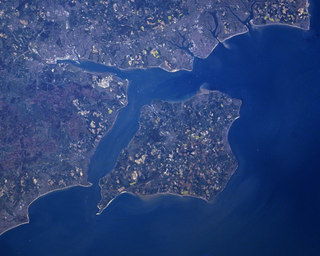
The Solent is a strait between the Isle of Wight and mainland Great Britain. It is about 20 miles long and varies in width between 2+12 and 5 mi, although the Hurst Spit which projects 1+12 mi (2.4 km) into the Solent narrows the sea crossing between Hurst Castle and Colwell Bay to just over 1 mi (1.6 km).

<span class="mw-page-title-main">River Hamble</span> River in south Hampshire, England

The River Hamble is located in south Hampshire, England. It rises near Bishop's Waltham and flows for 10.1 km (6.3 mi) through Botley, Bursledon, and Lower Swanwick before entering Southampton Water between Hamble Common and Warsash.

<span class="mw-page-title-main">River Test</span> River in Hampshire, England

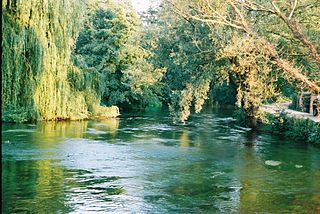
The River Test is a chalk stream in Hampshire in the south of England. It rises at Ashe near Basingstoke and flows southwards for 40 miles (64 km) to Southampton Water. Settlements on the Test include the towns of Stockbridge and Romsey. Below the village of Longparish, the river is broadly followed by the Test Way, a long-distance footpath.

<span class="mw-page-title-main">Hythe, Hampshire</span> Town in England

Hythe is a town near Southampton, Hampshire, England. It is located by the shore of Southampton Water, and has a ferry service connecting it to Southampton. Hythe has a small shopping area, a pier, and a marina for yachts.

<span class="mw-page-title-main">River Itchen, Hampshire</span> River in Hampshire, England

The River Itchen in Hampshire, England, rises to the south of New Alresford and flows 26 miles (42 km) to meet Southampton Water below the Itchen Bridge. The Itchen Navigation was constructed in the late 17th and early 18th centuries to enable barges to reach Winchester from Southampton Docks, but ceased to operate in the mid-19th century and is largely abandoned today.

<span class="mw-page-title-main">Marchwood</span> Human settlement in England

Marchwood is a village and civil parish located in Hampshire, England, United Kingdom. It lies between Totton and Hythe on the western shore of Southampton Water and directly east of the New Forest. The population of the village in the 2011 census was 6,141.

<span class="mw-page-title-main">Romsey (UK Parliament constituency)</span>

Romsey was a seat of the House of Commons of the UK Parliament 1983–2010 which accordingly elected one Member of Parliament (MP) by the first past the post system of election. It is virtually tantamount to its replacement Romsey and Southampton North which takes in two typical-size local government wards of the United Kingdom named after and approximate to the Bassett and Swaythling parts of Southampton.

<span class="mw-page-title-main">Solent Way</span> Long-distance footpath in Hampshire, England

The Solent Way is a 60-mile (97 km) long-distance footpath in Hampshire, southern England. With the exception of a few inland diversions, the path follows the coast of the Solent, the sea strait that separates the mainland from the Isle of Wight. The Solent Way forms part of the E9 European Coastal Path, which runs for 5000 km (3125 miles) from Cape St Vincent in Portugal to Narva-Jõesuu in Estonia.

<span class="mw-page-title-main">Dibden Purlieu</span> Human settlement in England

Dibden Purlieu is a village situated on the edge of the New Forest in Hampshire, England. The village merges with the nearby town of Hythe. It is in the civil parish of Hythe and Dibden.

<span class="mw-page-title-main">Chessel Bay</span> Local Nature Reserve in Southampton, England

Chessel Bay is a 12.9-hectare (32-acre) Local Nature Reserve on the east bank of the River Itchen in Southampton in Hampshire. It is owned and managed by Southampton City Council. It is part of Solent and Southampton Water Ramsar site and Special Protection Area, and of Lee-on-The Solent to Itchen Estuary, which is a Site of Special Scientific Interest. It has been a local nature reserve since 1989

<span class="mw-page-title-main">Fawley branch line</span> Branch railway in Hampshire, England

The Fawley branch line, also known as the Waterside line is a standard-gauge railway line to Fawley, in the English county of Hampshire. It is on the opposite side of Southampton Water from the city of Southampton itself, in an area known as Waterside. For 40 years a passenger service operated, but this was withdrawn with the exception of the occasional enthusiasts' railtour. The line serves the freight needs of Marchwood Military Port, having also served the same function for Fawley Refinery until 2016.

<span class="mw-page-title-main">Port of Southampton</span> Passenger and cargo port in Southampton, England

The Port of Southampton is a passenger and cargo port in the central part of the south coast of England. The modern era in the history of the Port of Southampton began when the first dock was inaugurated in 1843. The port has been owned and operated by Associated British Ports since 1982, and is the busiest cruise terminal and second largest container port in the UK. The volume of port traffic categorises Southampton as a Medium-Port City globally.

<span class="mw-page-title-main">River Hamble Country Park</span> Park in Hampshire, England

River Hamble Country Park is a 144.1-hectare (356-acre) Local Nature Reserve which runs along the west bank of the River Hamble between the villages of Botley and Bursledon in Hampshire. It is owned by Hampshire County Council and managed by Hampshire Countryside Service. It is part of Solent and Southampton Water Ramsar site and Special Protection Area, and of Solent Maritime Special Area of Conservation. Part of it is in Upper Hamble Estuary and Woods, which is a Site of Special Scientific Interest.

<span class="mw-page-title-main">Hythe to Calshot Marshes</span>

Hythe to Calshot Marshes is a 591.8-hectare (1,462-acre) biological Site of Special Scientific Interest which stretches along the west bank of Southampton Water between Calshot and Marchwood in Hampshire. It is part of Solent and Southampton Water Ramsar site and Special Protection Area, and of Solent Maritime Special Area of Conservation. Calshot Marshes is a Local Nature Reserve and Hythe Spartina Marsh is a nature reserve managed by the Hampshire and Isle of Wight Wildlife Trust.

<span class="mw-page-title-main">Lee-on-The Solent to Itchen Estuary</span>

Lee-on-The Solent to Itchen Estuary is a 585.9-hectare (1,448-acre) biological and geological Site of Special Scientific Interest which stretches along the coast between Southampton and Gosport in Hampshire. It is a Geological Conservation Review site. It is part of Solent and Southampton Water Ramsar site and Special Protection Area, and of Solent Maritime Special Area of Conservation. Three areas are Local Nature Reserves, Chessel Bay, Hook with Warsash and Mercury Marshes. One area is Hamble Common Camp, a Scheduled Monument.

<span class="mw-page-title-main">Upper Hamble Estuary and Woods</span>

Upper Hamble Estuary and Woods is a 151.2-hectare (374-acre) biological Site of Special Scientific Interest east of Southampton in Hampshire. It is part of Solent and Southampton Water Ramsar site and Special Protection Area, and of Solent Maritime Special Area of Conservation. Part of the site is in Manor Farm Country Park, which is a Local Nature Reserve.

<span class="mw-page-title-main">Hook with Warsash</span>

Hook with Warsash is a 251.6-hectare (622-acre) Local Nature Reserve west of Fareham in Hampshire. It is owned by Hampshire County Council and managed by Hampshire Countryside Service. It is part of Solent and Southampton Water Ramsar site and Special Protection Area, of Solent Maritime Special Area of Conservation, and of Lee-on-The Solent to Itchen Estuary Site of Special Scientific Interest.

<span class="mw-page-title-main">Mercury Marshes</span>

Mercury Marshes is a 6.4-hectare (16-acre) Local Nature Reserve in Hamble-le-Rice in Hampshire. It is owned by Hampshire County Council and managed by Hampshire Countryside Service. It is part of Solent and Southampton Water Ramsar site and Special Protection Area, of Solent Maritime Special Area of Conservation, and of Lee-on-The Solent to Itchen Estuary, which is a Site of Special Scientific Interest.

References

  1. "Solent and Southampton Water". Ramsar Sites Information Service. Retrieved 25 April 2018.
  2. 1908 Summer Olympics official report. p. 351.
  3. Ian, West. "Geology of Fawley Power Station Excavations" . Retrieved 22 April 2012.
  4. Associated British Ports Consultation
  5. 1 2 Raymont, J.E.G (1964). "The Marine Fauna of Southampton Water". Survey of Southampton and Its Region. British Association for the Advancement of Science Southampton Meeting, 1964. Southampton University Press. p. 119.
  6. 1 2 "Mercenaria mercenaria". Joint Nature Conservation Committee. Joint Nature Conservation Committee. 25 April 2006. Retrieved 10 January 2017.