
The Solent Way is a 60-mile (97 km) long-distance footpath in Hampshire, southern England. With the exception of a few inland diversions, the path follows the coast of the Solent, the sea strait that separates the mainland England from the Isle of Wight. The Solent Way forms part of the E9 European Coastal Path, which runs for 5000 km (3125 miles) from Cape St Vincent in Portugal to Narva-Jõesuu in Estonia.

Hampshire and Isle of Wight Wildlife Trust is a Wildlife Trust with 27,000 members across the counties of Hampshire and the Isle of Wight, England.
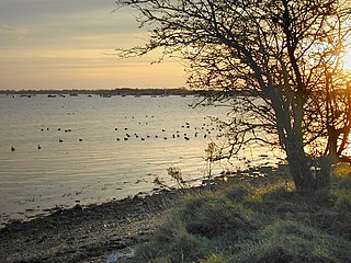
Langstone Harbour is a 2,085.4-hectare (5,153-acre) biological Site of Special Scientific Interest in Hampshire. It is an inlet of the English Channel in Hampshire, sandwiched between Portsea Island to the south and west, Hayling Island to the south and east, and Langstone to the north. It is part of Chichester and Langstone Harbours Ramsar site, Special Protection Area and Nature Conservation Review site, Grade I. Parts of it are in Solent Maritime and Solent and Isle of Wight Lagoons Special Areas of Conservation. Three areas are Local Nature Reserves, Farlington Marshes West Hayling and The Kench, Hayling Island. Two areas are nature reserves managed by the Hampshire and Isle of Wight Wildlife Trust, Farlington Marshes and Southmoor Nature Reserve

Keyhaven is a hamlet on the south coast of England in the county of Hampshire. It is a fishing village, but the trade has been in decline for a period of years and its main draw now is tourism, especially sailing.
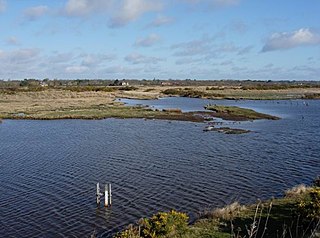
Keyhaven, Pennington, Oxey and Normandy Marshes, also known as the North Solent Marshes, are three areas of saltmarsh in Hampshire, England. The village of Keyhaven lies to the west, the village of Pennington to the north, and the town of Lymington to the northeast. The marshes lie behind Hurst Spit and fall within the Hurst Castle And Lymington River Estuary Site of Special Scientific Interest.
Farlington Marshes is a 119.7-hectare (296-acre) Local Nature Reserve in Portsmouth in Hampshire. It is owned by Portsmouth City Council and managed by Hampshire and Isle of Wight Wildlife Trust. It is part of Langstone Harbour, which is a Site of Special Scientific Interest and a Nature Conservation Review site, Grade I. It is also part of Solent Maritime Special Area of Conservation and of Chichester and Langstone Harbours Ramsar site and Special Protection Area
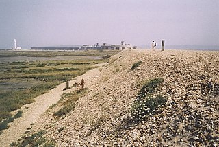
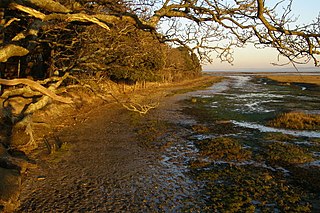
Hurst Spit is a one-mile-long (1.6 km) shingle bank near the village of Keyhaven, at the western end of the Solent, on the south coast of England. The spit shelters an area of saltmarsh and mudflats known as Keyhaven and Pennington marshes. At the end of the spit is Hurst Castle, an artillery fortress originally built on the orders of King Henry VIII, and much enlarged in the 19th century. Hurst Point Lighthouse was built on the end of Hurst Spit in the 1860s.

Hurst Castle and Lymington River Estuary is a 1,077.3-hectare (2,662-acre) biological and geological Site of Special Scientific Interest near Lymington in Hampshire. It is a Nature Conservation Review site and two areas are Geological Conservation Review sites. Three areas are Local Nature Reserves, Boldre Foreshore, Sturt Pond and Lymington and Keyhaven Marshes; the latter site is managed by the Hampshire and Isle of Wight Wildlife Trust. Part of it is North Solent National Nature Reserve. It is part of Solent and Southampton Water Ramsar site and Special Protection Area. Parts of it are in Solent Maritime and Solent and Isle of Wight Lagoons Special Areas of Conservation.

Hythe to Calshot Marshes is a 591.8-hectare (1,462-acre) biological Site of Special Scientific Interest which stretches along the west bank of Southampton Water between Calshot and Marchwood in Hampshire. It is part of Solent and Southampton Water Ramsar site and Special Protection Area, and of Solent Maritime Special Area of Conservation. Calshot Marshes is a Local Nature Reserve and Hythe Spartina Marsh is a nature reserve managed by the Hampshire and Isle of Wight Wildlife Trust.

Lee-on-The Solent to Itchen Estuary is a 585.9-hectare (1,448-acre) biological and geological Site of Special Scientific Interest which stretches along the ooast between Southampton and Gosport in Hampshire. It is a Geological Conservation Review site. It is part of Solent and Southampton Water Ramsar site and Special Protection Area, and of Solent Maritime Special Area of Conservation. Three areas are Local Nature Reserves, Chessel Bay, Hook with Warsash and Mercury Marshes. One area is Hamble Common Camp, a Scheduled Monument.
Lincegrove and Hackett's Marshes is a 37.8-hectare (93-acre) biological Site of Special Scientific Interest on the west bank of the River Hamble between Southampton and Fareham in Hampshire. It is part of Solent and Southampton Water Ramsar site and Special Protection Area, and of Solent Maritime Special Area of Conservation. Hackett's Marsh is a 20.4 hectares Local Nature Reserve.

Lower Test Valley is a 142-hectare (350-acre) biological Site of Special Scientific Interest near Totton in Hampshire. It is part of Solent and Southampton Water Ramsar site and Special Protection Area, and of Solent Maritime Special Area of Conservation. It is a nature reserve managed by the Hampshire and Isle of Wight Wildlife Trust.

Lymington River SSSI is a 34.8-hectare (86-acre) biological and geological Site of Special Scientific Interest along Lymington River and its tributaries between Lymington, Burley and Stoney Cross in Hampshire. HIghland Water is a Geological Conservation Review site and Ober Water is a Nature Conservation Review site, Grade I. Parts of the site are in The New Forest and Solent and Southampton Water Ramsar sites, and in The New Forest Special Protection Area.

Lymington River Reedbeds is a 41.7-hectare (103-acre) biological Site of Special Scientific Interest in Lymington in Hampshire. It is a nature reserve managed by the Hampshire and Isle of Wight Wildlife Trust. It is part of Solent and Southampton Water Ramsar site and Special Protection Area.

North Solent is a 1,186.7-hectare (2,932-acre) biological and geological Site of Special Scientific Interest along the north bank of the Solent between East End and Calshot in Hampshire. It is a Nature Conservation Review site, Grade I. Part of it is in North Solent National Nature Reserve and two areas are Geological Conservation Review sites. It is part of Solent and Southampton Water Ramsar site and Special Protection Area, and of Solent Maritime Special Area of Conservation. Boldre Foreshore is a Local Nature Reserve.
Boldre Foreshore is a 193.3-hectare (478-acre) Local Nature Reserve east of Lymington in Hampshire. It is owned by New Forest District Council and managed by the Hampshire and Isle of Wight Wildlife Trust. It is part of Solent and Southampton Water Ramsar site and Special Protection Area, Solent Maritime Special Area of Conservation, Hurst Castle and Lymington River Estuary Site of Special Scientific Interest and Lymington and Keyhaven Marshes, a nature reserve managed by the Hampshire and Isle of Wight Wildlife Trust.

Calshot Marshes is a 51.1-hectare (126-acre) Local Nature Reserve near Calshot, at the junction of The Solent and Southampton Water in Hampshire. It is owned by Hampshire County Council and managed by Hampshire Countryside Service. It is part of Solent and Southampton Water Ramsar site and Special Protection Area, of Solent Maritime Special Area of Conservation and of Hythe to Calshot Marshes Site of Special Scientific Interest.

Mercury Marshes is a 6.4-hectare (16-acre) Local Nature Reserve in Hamble-le-Rice in Hampshire. It is owned by Hampshire County Council and managed by Hampshire Countryside Service. It is part of Solent and Southampton Water Ramsar site and Special Protection Area, of Solent Maritime Special Area of Conservation, and of Lee-on-The Solent to Itchen Estuary, which is a Site of Special Scientific Interest.
