Totton

Last updated
Totton
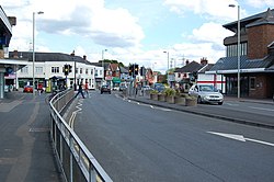
Totton Town Centre - geograph.org.uk - 1315864.jpg
Hampshire UK location map.svg
Red pog.svg
Totton
Location within Hampshire
Area7.072 km2 (2.731 sq mi)
Population28,094 (2021 census)
  Density 3,973/km2 (10,290/sq mi)
Civil parish
District
Shire county
Region
Country England
Sovereign state United Kingdom
Police Hampshire and Isle of Wight
Fire Hampshire and Isle of Wight
Ambulance South Central
List of places
UK
England
Hampshire
50°55′08″N1°29′20″W / 50.918879°N 1.4887938°W / 50.918879; -1.4887938

Totton is a town in the civil parish of Totton and Eling, in the New Forest district, in the county of Hampshire, England. In 2021 it had a population of 28,094. [1]

Contents

History

The name "Totton" means 'Tot(r)ingtun' farm of 'Tot(t)a', "Totton was "Totinctone" in 985 and "Totyngton" in 1174-1199. [2] Totton was recorded in the Domesday Book as Dodintune. [3]

Totton claimed to be the largest village in England until it was made a town in 1974. [4] The town is often considered to be made up of several smaller villages, such as Testwood, Calmore and Hammonds Green (as well as the original village of Totton) which have been connected by new clusters of housing to form the town as it is today. This is backed up by the presence of several areas of local shops, which served their respective villages in the past, and to an extent still do today. Until the 1967 forest perambulation fencing, New Forest ponies were free to roam its streets. The town's built up area has swollen significantly since the later half of the 20th century and now forms a near continuous web of development with surrounding villages, with Ower, Netley Marsh and Ashurst in particular having little or no discernible distinction in built up area.

Totton's town centre has changed little since the 1970s. Commercial Road and the A35 causeway are the main exit routes from the town.

Early history

The Iron Age Hillfort at Tatchbury Mount is evidence of early settlement in the Totton area [5] and Netley Marsh on the edge of Totton was the site of an early battle between Anglo Saxon invaders under Cerdic and Romano-Celtic peoples under Natanleod. [5] The construction of Testwood Lakes revealed a treasure-trove of ancient artefacts including one of the oldest known bridges in England, believed to date to around c.1,500BC. [6]

Totton Appears on the "Hantoniae sive Sovthantonensis Comitatvs" map in Joan Blaeu's Atlas Major Vol. 5 Published in 1665 [7]

The area's history is inevitably closely connected with ship and boat building but more with its timber trade. It was the site of much illegal dealing in the timber unlawfully obtained from the New Forest. [8]

Related Research Articles

<span class="mw-page-title-main">Totton and Eling</span> Civil parish in Hampshire, England

Totton and Eling is a civil parish in Hampshire, England, with a population of 28,970 people. It contains the settlements of Totton, Eling, Calmore, Hounsdown, Rushington and Testwood. It is situated between the eastern edge of the New Forest and the River Test, close to the city of Southampton but outside the city boundary; the town is within the New Forest non-metropolitan district. Surrounding towns and villages include Ashurst, Marchwood, Cadnam and Ower.

<span class="mw-page-title-main">New Forest District</span> Non-metropolitan district in England

New Forest is a local government district in Hampshire, England. Its council is based in Lyndhurst, although the largest town is Totton. The district also includes the towns of Fordingbridge, Lymington, New Milton and Ringwood. The district is named after and covers most of the New Forest National Park, which occupies much of the central part of the district. The main urban areas are around the periphery of the forest. The district has a coastline onto the Solent to the south and Southampton Water to the east.

<span class="mw-page-title-main">Marchwood</span> Village and parish in Hampshire, England

Marchwood is a village and civil parish located in Hampshire, England. It lies between Totton and Hythe on the western shore of Southampton Water and directly east of the New Forest. The population of the village in the 2011 census was 6,141.

<span class="mw-page-title-main">History of Hampshire</span> History of the English county

Hampshire is a county in Southern England with some notable archaeology and many notable historic buildings.

<span class="mw-page-title-main">Romsey (UK Parliament constituency)</span> Former parliamentary constituency in the United Kingdom

Romsey was a seat of the House of Commons of the UK Parliament 1983–2010 which accordingly elected one Member of Parliament (MP) by the first past the post system of election. It is virtually tantamount to its replacement Romsey and Southampton North which takes in two typical-size local government wards of the United Kingdom named after and approximate to the Bassett and Swaythling parts of Southampton.

<span class="mw-page-title-main">New Forest East (UK Parliament constituency)</span> Parliamentary constituency in the United Kingdom, 1997 onwards

New Forest East is a constituency in Hampshire represented in the House of Commons of the UK Parliament since its creation in 1997 by Julian Lewis of the Conservative Party.

<span class="mw-page-title-main">Ashurst, Hampshire</span> Village in Hampshire, England

Ashurst is a village in the New Forest district of Hampshire, England, which together with Colbury hamlet makes the parish of Ashurst and Colbury. Ashurst is on the A35 road near the Southampton conurbation. According to the 2001 census the parish had a population of 2,011, increasing to 2,093 at the 2011 Census. The parish is on the edge of the designated New Forest National Park area. The village has a campsite, some shops and a railway station. The parish is bounded to the west by Netley Marsh parish and the Bartley Water, to the north by the A326 road and Totton and Eling, and to the south by Denny Lodge parish in the New Forest.

<span class="mw-page-title-main">Dibden Purlieu</span> Village in Hampshire, England

Dibden Purlieu is a village situated on the edge of the New Forest in Hampshire, England. The village merges with the nearby town of Hythe. It is in the civil parish of Hythe and Dibden.

<span class="mw-page-title-main">A.F.C. Totton</span> Association football club in England

Amalgamated Football Club Totton is a football club based in Totton, Hampshire, England. The club is affiliated to the Hampshire Football Association and is an FA Standard Chartered club. They are currently members of the Southern League Premier Division South and play at the Testwood Stadium.

<span class="mw-page-title-main">River Blackwater (River Test)</span> River in Hampshire and Wiltshire, England

This River Blackwater drains small parts of the English counties of Hampshire and Wiltshire. It is a tributary of the River Test.

<span class="mw-page-title-main">Minstead</span> Village and parish in Hampshire, England

Minstead is a small village and civil parish in the New Forest, Hampshire, about 2 miles (3.2 km) north of Lyndhurst. There is a shop and a pub, the Trusty Servant. Sir Arthur Conan Doyle's grave is under a large tree at the back of the 13th-century All Saints' church.

<span class="mw-page-title-main">Testwood Lakes</span>

Testwood Lakes is a 55-hectare (140-acre) nature reserve in Totton to the northwest of Southampton in Hampshire, England. It is managed by the Hampshire and Isle of Wight Wildlife Trust. The three lakes, which are owned by Southern Water and provide water for Hampshire, are called Little Testwood Lake, Testwood Lake and Meadow Lake. There is a visitor centre at the site.

<span class="mw-page-title-main">Winsor, Hampshire</span> Village in Hampshire, England

Winsor is a village in the civil parish of Copythorne, in Hampshire, England. It is situated within the boundaries of the New Forest National Park. Surrounding villages are Copythorne to the west, Netley Marsh to the southeast, and Bartley to the south west.

<span class="mw-page-title-main">South Charford</span> Human settlement in England

South Charford is a hamlet in the civil parish of Breamore, in the New Forest district, in Hampshire, England. It is on the west bank of the River Avon.

<span class="mw-page-title-main">Netley Marsh</span> Human settlement in England

Netley Marsh is a village and civil parish in Hampshire, close to the town of Totton. It lies within the New Forest District, and the New Forest National Park. It is the supposed site of the battle between an invading Anglo Saxon army, under Cerdic and a British army under the probably fictitious king Natanleod in the year 508.

<span class="mw-page-title-main">Testwood School</span> Academy in Totton, Southampton, Hampshire

Testwood School is a secondary school with academy status located in the town of Totton and Eling, England. The school was built in the late 1930s but its opening was delayed by World War II. The school takes pupils between 11 and 16, and holds adult skills classes after school hours.

<span class="mw-page-title-main">Ower</span> Hamlet in Hampshire, England

Ower is a hamlet in the New Forest district of Hampshire, England. Its nearest towns are Totton – approximately 3 miles (4.8 km) to the southeast, and Romsey – around 4 miles (6.4 km) to the north-east.

<span class="mw-page-title-main">Woodlands, Hampshire</span> Village in Hampshire, England

Woodlands is a village in the New Forest National Park of Hampshire, England. The village lies 6 miles (9.7 km) west from Southampton and 2+34 miles (4.4 km) north-east from Lyndhurst. The village is in the civil parish of Netley Marsh.

<span class="mw-page-title-main">2017 Hampshire County Council election</span> 2017 UK local government election

The 2017 Hampshire County Council election took place on 4 May 2017 as part of the 2017 local elections in the United Kingdom. All councillors were elected from electoral divisions by first-past-the-post voting for a four-year term of office. The electoral divisions were somewhat changed from the previous election, with some being split, merged or with boundary changes. No elections were held in Portsmouth and Southampton, which are unitary authorities and hold their elections in other years. Similarly the districts within Hampshire did also not hold elections this year.

<span class="mw-page-title-main">Tatchbury Mount Hospital</span> Hospital in Hampshire, England

Tatchbury Mount Hospital is a health facility to the north of Totton, Hampshire, England. It is owned and managed by Southern Health NHS Foundation Trust and acts as the Trust's headquarters. The site was formerly a large psychiatric hospital with the majority of the buildings on the site dedicated to this purpose, however in recent years changes in the management of these patients has resulted in the uses for the site diversifying.

References

  1. "Totton". City Population De. Retrieved 9 January 2025.
  2. "Totton". New Forest Online. Retrieved 15 September 2022.
  3. "Hampshire L-Z". The Domesday Book Online. Retrieved 25 September 2021.
  4. "Totton". New Forest Online.
  5. 1 2 "Netley Marsh". .hants.gov.uk. 8 November 2006. Archived from the original on 13 March 2012. Retrieved 18 July 2011.
  6. "Testwood Lakes | Wessex Archaeology". Wessexarch.co.uk. 28 April 2008. Retrieved 18 July 2011.
  7. "Hantoniae sive Sovthantonensis Comitatvs - Volume 5 - Blaeu Atlas Maior, 1662-5".
  8. TNA ADM 106/904/199, 238 Mr. Winnington. Opinion on the knee of timber allegedly stolen from the New Forest 7 July 1738: ADM 106/904/244 Mr. Winnington, Lincoln's Inn. Account of the trial of Thomas Tucker for receiving the knee of timber from the New Forest. Found not guilty 17 July 1738