The A1, also known as the Great North Road, is the longest numbered road in the United Kingdom, at 410 miles (660 km). It connects London, the capital of England, with Edinburgh, the capital of Scotland. The numbering system for A-roads, devised in the early 1920s, was based around patterns of roads radiating from two hubs at London and Edinburgh. The first number in the system, A1, was given to the most important part of that system: the road from London to Edinburgh, joining the two central points of the system and linking the UK's (then) two mainland capital cities. It passes through or near north London, Hatfield, Welwyn Garden City, Stevenage, Baldock, Letchworth Garden City, Biggleswade, Eaton Socon, Buckden, Peterborough, Stamford, Grantham, Newark-on-Trent, Retford, Doncaster, Pontefract, York, Wetherby, Ripon, Darlington, Durham, Gateshead, Newcastle upon Tyne, Morpeth, Alnwick and Berwick-upon-Tweed.

The A6 is one of the main north–south roads in England. It runs from Luton in Bedfordshire to Carlisle in Cumbria, although it formerly started at a junction with the A1 at Barnet in north London, and is described as running from London to Carlisle. It is the fourth longest numbered road in Britain; only the A1, A38 and A30 are longer.

The A57 is a major road in England. It runs east from Liverpool to Lincoln via Warrington, Salford and Manchester, and then through the Pennines over the Snake Pass (between the high moorlands of Bleaklow and Kinder Scout), around the Ladybower Reservoir, through Sheffield and past Worksop. Between Liverpool and Glossop, the road has largely been superseded by the M62, M602 and M67 motorways. Within Manchester a short stretch becomes the Mancunian Way, designated A57(M).

The M27 is a motorway in Hampshire, England. It is 27.9 miles (44.9 km) long and runs between Cadnam and Portsmouth. It was opened in stages between 1975 and 1983, providing the largest two urban areas in Hampshire with a direct motorway link. An extension into the county of West Sussex was planned but never constructed. A number of smaller motorways were proposed, connecting the city centres of Southampton and Portsmouth to the motorway; of these only the M271 and M275 were built. Three sections of the M27 have since been widened to four lanes each way, the first between junctions 7 and 8, the second between junctions 3 and 4, and the third begins at the slip road where junction 11 joins until mid-way to junction 12.
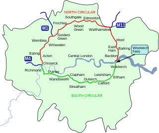
The North Circular Road is a 25.7-mile-long (41.4 km) ring road around Central London in England. It runs from Chiswick in the west to Woolwich in the east via suburban North London, connecting various suburbs and other trunk roads in the region. Together with its counterpart, the South Circular Road, it mostly forms a ring road around central London, except for crossing of the River Thames, which is done by the Woolwich Ferry.
The South Circular Road in south London, England, is a major road that runs from the Woolwich Ferry in the east to the Chiswick Flyover in the west via Eltham, Lee Green, Catford, Forest Hill, Dulwich, Tulse Hill, Clapham Common, Clapham Junction, Wandsworth, Putney, Barnes, Mortlake and Kew Bridge. Together with the North Circular Road and Woolwich Ferry, it makes a complete ring-road around Central London and is a former boundary of the Ultra Low Emission Zone. The South Circular is largely a sequence of urban streets joined together, requiring several at-grade turns, unlike the mostly purpose-made carriageways of the North Circular. As a result, it is frequently congested.

The A46 is a major A road in England. It starts east of Bath, Somerset and ends in Cleethorpes, Lincolnshire, but it does not form a continuous route. Large portions of the old road have been lost, bypassed, or replaced by motorway development. Between Leicester and Lincoln the road follows the course of the Roman Fosse Way, but between Bath and Leicester, two cities also linked by the Fosse Way, it follows a more westerly course.
The A15 is a major road in England. It runs north from Peterborough via Market Deeping, Bourne, Sleaford and Lincoln along a variety of ancient, Roman, and Turnpike alignments before it is interrupted at its junction with the M180 near Scawby. The road restarts 10 miles (16 km) east, and then continues north past Barton-upon-Humber, crossing the Humber on the Humber Bridge before terminating at Hessle near Kingston upon Hull.

The A31 is a major trunk road in southern England that runs from Guildford in Surrey to Bere Regis in Dorset. Its best-known section is the Hog's Back, a ridge forming part of the North Downs between Guildford and Farnham in Surrey.

The A48 is a trunk road in Great Britain running from the A40 at Highnam, 3 miles (4.8 km) west of Gloucester, England, to the A40 at Carmarthen, Wales. Before the Severn Bridge opened on 8 September 1966, it was a major route between England and South Wales. For most of its route, it runs almost parallel to the M4 motorway. During times of high winds at the Severn Bridge, the A48 is used as part of the diversion route and is still marked as a Holiday Route.

The A35 is a major road in southern England, connecting Honiton in Devon and Southampton in Hampshire. It is a trunk road for some of its length. Most of its route passes through Dorset and the New Forest. It originally connected Exeter and Southampton, the original A35 ran along what is now the A3052 joining the present road at Charmouth.
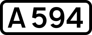
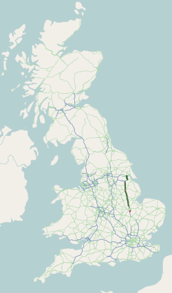
The A594 Central Ring is Leicester's central distributor road network.
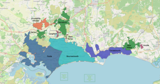
The South East Dorset conurbation is a multi-centred conurbation on the south coast of Dorset in England.

The A17 road is a mostly single carriageway road linking Newark-on-Trent in Nottinghamshire, England, to King's Lynn in Norfolk. It stretches for a distance of 62 miles travelling across the flat fen landscapes of southern Lincolnshire and western Norfolk and links the East Midlands with East Anglia. The road is notable for its numerous roundabouts and notoriously dangerous staggered junctions and also for its most famous landmark, the Cross Keys Bridge at Sutton Bridge close to the Lincolnshire/Cambridgeshire/Norfolk borders which carries the road over the River Nene.

The A171 is a road in England that links the North Yorkshire towns of Middlesbrough, Guisborough, Whitby, Robin Hood's Bay and Scarborough. Locally it is known as The Moor Road. The road is mostly single carriageway but has some sections of dual carriageway. The distance between the two towns is 47 miles (75 km)

Godshill is a village and civil parish and in New Forest National Park in Hampshire, England. It is about 1+1⁄2 miles (2.4 km) east of the town of Fordingbridge and 10 miles (16 km) south of the city of Salisbury.

The A338 is a major primary route in southern England, that runs from the junction with the A35 at Poole in Dorset to the junction with the A420 at Besselsleigh in Oxfordshire, a distance of 84 miles (135 km).

Fritham is a small village in Hampshire, England. It lies in the north of the New Forest, near the Wiltshire border. It is in the civil parish of Bramshaw.

Ogdens is a small hamlet south of Hyde Common near Frogham in the New Forest area of Hampshire, England.

Frogham is a small village in the New Forest National Park of Hampshire, England. It is in the civil parish of Hyde. Its nearest town is Fordingbridge, which lies approximately 1.8 miles (2.5 km) north-west from the village.


