
Marchwood is a village and civil parish located in Hampshire, England. It lies between Totton and Hythe on the western shore of Southampton Water and directly east of the New Forest. The population of the village in the 2011 census was 6,141.

Fawley is a village and civil parish in Hampshire, England. It is situated in the New Forest on the western shore of the Solent, approximately 7 miles south of Southampton. Fawley is also the site of Fawley Refinery, operated by ExxonMobil, which is the largest facility of its kind in the United Kingdom. The decommissioned Fawley Power Station is also located less than a mile to the south east of the village.

Hordle is a village and civil parish in the county of Hampshire, England. It is situated between the Solent coast and the New Forest, and is bordered by the towns of Lymington and New Milton. Like many New Forest parishes Hordle has no village centre. The civil parish includes the hamlets of Tiptoe and Everton as well as part of Downton. The parish was originally much larger; stretching from the New Forest boundary to Hurst Castle.
Liss is a village and civil parish in the East Hampshire district of Hampshire, 3.3 miles (5.3 km) north-east of Petersfield, on the A3 road, on the West Sussex border. It covers 3,567 acres (14 km2) of semi-rural countryside in the South Downs National Park. Liss railway station is on the Portsmouth Direct line. The village comprises an old village at West Liss and a modern village round the 19th-century station. They are divided by the River Rother. Suburbs later spread towards Liss Forest.

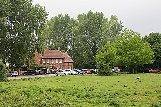
Boldre is a village and civil parish in the New Forest district of Hampshire, England. It is in the south of the New Forest National Park, above the broadening (estuary) of the Lymington River, two miles (3 km) north of Lymington. In the 2001 census, the parish had a population of 1,931, and in the 2011 census, 2,003. The parish has a few campsites and a tourist caravan site, along with visitor parking around its mixed woodland and heath hamlet of Norley Wood.

Leckhampton is a village and a district in south Cheltenham, Gloucestershire, England. The area is in the civil parish of Leckhampton with Warden Hill and is part of the district of Cheltenham. The population of the civil parish taken at the 2011 census was 4,409.

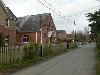
Sway is a village and civil parish in Hampshire in the New Forest national park in England. The civil parish was formed in 1879, when lands were taken from the extensive parish of Boldre. The village has shops and pubs, and a railway station on the South West Main Line from Weymouth and Bournemouth to Southampton and London Waterloo. It is the site of Sway Tower, a 66-metre (217 ft) concrete folly built in the 19th century. The outbuildings of the Grade II listed Forest Heath House are used as artist studios and exhibition space by the charity SPUDWorks.

Rockbourne is a village and civil parish in the English county of Hampshire, close to Fordingbridge.
Whitsbury is a village and civil parish in Hampshire, England, close to Fordingbridge. Whitsbury is a part of a group of villages on the edge of the Cranborne Chase and West Wiltshire Downs Area of Outstanding Natural Beauty.

Rogate is a village and civil parish in the Chichester district of West Sussex, England, in the Western Rother valley. The village is on the A272 road 5.6 miles (9.0 km) west of Midhurst and 5 miles (8.0 km) east of Petersfield, Hampshire. The civil parish includes the villages of Rogate and Rake and the hamlets of Haben, Fyning, Hill Brow, Langley, Durford, Wenham, Durleighmarsh and Terwick Common.

Fritham is a small village in Hampshire, England. It lies in the north of the New Forest, near the Wiltshire border. It is in the civil parish of Bramshaw.

Hale is a small village and civil parish in Hampshire, England. It lies on the border of the New Forest, overlooking the valley of the River Avon. The village is about 3.5 miles (5.6 km) north-east of the town of Fordingbridge, and about 8 miles (13 km) south of the city of Salisbury. Within the parish stands Hale House, a large 18th-century mansion which was the country house of architect Thomas Archer, who also rebuilt Hale church in 1717.

Battramsley is a hamlet in the civil parish of Boldre, in the New Forest in Hampshire, England.

East Boldre is a linear village and civil parish situated near Lymington, Hampshire, England. East Boldre is surrounded by the New Forest and forms part of the district of New Forest.

Ellingham is a small village and former civil parish, now in the parish of Ellingham, Harbridge and Ibsley, in the New Forest district, in the county of Hampshire, England. It is near Ringwood, west of the New Forest National Park. Ellingham is most famous for the story of Alice Lisle, who was executed by the infamous Judge Jeffreys in 1685, on the charge of harbouring fugitives after the defeat of the Monmouth Rebellion. In 1961 the parish had a population of 595.

Bank is a village in the English county of Hampshire. The settlement is within the civil parish of Lyndhurst in the New Forest, and is located approximately 8 miles (13 km) from both Ringwood and Southampton. It has one inn and approximately 30 distinct dwellings.
Rockford is a hamlet in the civil parish of Ellingham, Harbridge and Ibsley, in the New Forest district of Hampshire, England, on the western edge of the New Forest National Park. Its nearest town is Ringwood, which lies approximately 1.8 miles (2.9 km) south from the hamlet.

South Baddesley is a small village in the civil parish of Boldre in the New Forest National Park of Hampshire, England. It lies 2.3 miles (3.7 km) north-east from Lymington, its nearest town.

Ashley is a village located in the southwest of Hampshire, England. It lies on the eastern outskirts of New Milton in the New Forest district, and is two miles (3 km) inland from the sea. Its history dates back to the Domesday book of 1086, when two estates were recorded. In the 15th century much of Ashley merged with a neighbouring manor, and the estate became known as Ashley Arnewood. As a village, Ashley began to develop in the 19th century when a church and a school were built. Most of the current village was built in the 20th century, and today Ashley is effectively a suburb of New Milton.


