Latchmore Brook

Last updated
The Latchmore Brook at Latchmore Bottom Ponies grazing at latchmore bottom new forest.jpg
The Latchmore Brook at Latchmore Bottom

The Latchmore Brook is a significant stream in the New Forest, Hampshire, England. It rises from the elevated gravel plateaus in the north of the Forest, north of Fritham, and drains into the River Avon north of Ibsley.

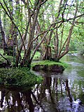
The stream's catchment is open heathland, deciduous woodland, silvicultural inclosures and, in its lower reaches, small scale pastoral farmland; as such there are no consistent sources of pollution and the stream's course and character has largely remained free from artificial modification. Historically, the greatest human impact on the brook was connected to the Schultze Gunpowder Factory which was established in the 1860s at Eyeworth Lodge near Fritham. The factory required large volumes of water and this demand was met by damming the brook to create a reservoir (which still survives as Eyeworth Pond). The problem of sulphuric and nitric acid discharges contaminating the river, killing fish, only ended when the factory closed in the 1920s.

Coordinates: 50°53′42″N1°47′18″W / 50.8950°N 1.7883°W / 50.8950; -1.7883

Related Research Articles

Walloomsac River river in the United States of America

The Walloomsac River from the Native American name, Wal-loom-sac is a 16.8-mile-long (27.0 km) tributary of the Hoosic River in the northeastern United States. It rises in southwestern Vermont, in the Green Mountains east of the town of Bennington in Woodford Hollow at the confluence of Bolles Brook and City Stream where it is labeled Walloomsac Brook on maps but is locally known as "The Roaring Branch". The river then flows west toward Bennington and passes the downtown area to the north. For many years this section was intermittent due to the water having been diverted to power mills in town. This divergence gave the name Walloomsac to a portion of the river flowing through town on the present course of South Stream. The combined Walloomsac / South Stream joins the Roaring Branch northwest of town. From here the river flows westward as the Walloomsac River and joins the Hoosic River below Hoosick Falls, New York.

Hope Valley, Derbyshire valley in Derbyshire, England

The Hope Valley is a rural area centred on the village of Hope, Derbyshire in the Peak District in the northern Midlands of England.

River Hodder river in Lancashire, United Kingdom

The River Hodder is a river in Lancashire, England. The river is a County Biological Heritage Site.

Eyeworth Pond human settlement in United Kingdom

Eyeworth Pond is a pond located near Fritham in the New Forest, in Hampshire, England.

Mollidgewock Brook is a 12.6-mile (20.3 km) long stream in northern New Hampshire and western Maine in the United States. It is a tributary of the Androscoggin River, which flows south and east into Maine, joining the Kennebec River near the Atlantic Ocean.

Lost River (New Hampshire) river in New Hampshire, United States of America

The Lost River is a 6.5-mile-long (10.5 km) stream located in the White Mountains of New Hampshire in the United States. It is a tributary of the Pemigewasset River, part of the Merrimack River watershed.

Fritham Village in Hampshire, England

Fritham is a small village in Hampshire, England. It lies in the north of the New Forest, near the Wiltshire border. It is in the civil parish of Bramshaw.

Monks Brook river in the English county of Hampshire

Monks Brook is a river in the English county of Hampshire. It is a tributary of the River Itchen, which it joins at a medieval salmon pool in Swaythling. The brook is formed from seven streams that rise in the chalky South Downs, with the official source of Monks Brook being known as Bucket's Corner. Monks Brook drains a clay catchment of 49 square kilometres (19 sq mi). The brook is designated a main river, which means the operating authority for managing it is the Environment Agency, not the local government authorities for the areas through which the river runs.

Black Brook (Chorley)

Black Brook in Lancashire has its source at Great Hill in the West Pennine Moors. The water is acidic due to a high level of peat in the uplands near to Round Loaf, giving the brook its brown colour. The young river was known as Warth Brook in olden Heapey. A feeder stream also known as Black Brook joins near Kittiwake Road - this short and weak water course commences at Eagle Tower. The jointed brook feeds Anglezarke Reservoir, and joins the River Yarrow in lowland Chorley at Yarrow Bridge. The entire course of Black Brook and the River Yarrow fall within Chorley and its villages.

Carrabassett River river in the United States of America

The Carrabassett River, a tributary of the Kennebec River, is located in Franklin County and Somerset County, Maine, in the United States. It rises near Sugarloaf Mountain, east of Rangeley Lake, and runs for 33.8 miles (54.4 km), flowing southeast past Kingfield and joining the Kennebec River in the town of Anson.

Skirden Beck Minor river in Lancashire, England

Skirden Beck is a minor river in Lancashire, England. It is approximately 4.3 miles (6.85 km) long and has a catchment area of 18.87 square miles (48.882 km2).

Eyeworth Human settlement in England

Eyeworth is a small, rural village and civil parish in the Central Bedfordshire district of the county of Bedfordshire, England; about 12.5 miles (20 km) east south-east of the county town of Bedford.

Indian Head River river in the United States of America

The Indian Head River rises on the southern boundary of Hanover, Massachusetts and northern boundary line of Hanson, Massachusetts at the intersection of tributaries from Drinkwater River in Hanover and Indian Head Brook in Hanson. The river then flows east along the Hanover-Pembroke border. The river, 3.7 miles (6.0 km) long, is a tributary of the North River, which flows into Massachusetts Bay. The Indian Head River was an important fishing and water pathway for the Massachuset Indian village of Mattakeeset which was located around the Pembroke Ponds.

The Little Southwest Branch Saint John River is a tributary of Southwest Branch Saint John River, flowing on 46.5 kilometres (28.9 mi) in Somerset County, in North Maine Woods, in Maine, in United States.

The Little Black River is a river flowing in the south of Quebec (Canada) and in the north of Maine.

Hancock Brook Trail

The 'Hancock Brook Trail' is a 2.8-mile (4.5 km) Blue-Blazed hiking trail Waterville Section of the City of Waterbury in New Haven County close to the borders of Thomaston and Plymouth, Litchfield County, Connecticut. It is contained overwhelmingly in a section of the Mattatuck State Forest bounded by Hancock Brook on the east, Thomaston Avenue on the west and Spruce Brook Road / Route 262 to the north.

Manitou River (Minnesota) river in the United States of America

The Manitou River is a 24.9-mile-long (40.1 km) river in northern Minnesota, which drains into Lake Superior along its north shore about three miles northeast of Little Marais. It flows southeast through the Superior National Forest, Finland State Forest, and George H. Crosby Manitou State Park in Lake County.

The Depot River is a tributary of the Big Black River, flowing in the townships T12 R17 Wels, T13 R16 Wels and T14 R15 Wels, in the Aroostook County in North Maine Woods in Maine, in United States.

In 1888 the 'Smokeless Powder Company', owned by James Dalziel Dougall Junior, the son of the famous glaswegian gunsmith -J D Dougall, took a 99-year lease for 126 arces around 'The Outpost', from the Youngsbury Estate. The site's name was changed from 'The Outpost' to Barwick and Barwick was formed as a 'factory hamlet'.

Tanners Brook

Tanner's Brook is an 8.5 km long river that rises in North Baddesley and flows to Southampton Water. The brook's name comes from a 19th-century tannery that stood close to where the river passed under Millbrook Road in Millbrook.