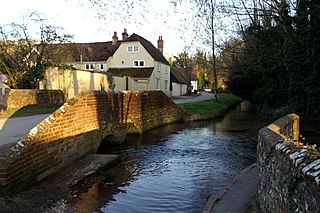
Titchfield

Last updated

Titchfield
Titchfield South Street.jpg
South Street, looking towards the square
Hampshire UK location map.svg
Red pog.svg
Titchfield
Location within Hampshire
Population7,280 (2011 Census. Fareham Ward) [1]
District
Shire county
Region
Country England
Sovereign state United Kingdom
Post town FAREHAM
Postcode district PO14 - PO15
Dialling code 01329
Police Hampshire and Isle of Wight
Fire Hampshire and Isle of Wight
Ambulance South Central
UK Parliament
List of places
UK
England
Hampshire
50°50′57″N1°14′04″W / 50.849084°N 1.234396°W / 50.849084; -1.234396

Titchfield is a village and former civil parish in the Fareham district, in southern Hampshire, England, by the River Meon. The village has a history stretching back to the 6th century. During the medieval period, the village operated a small port and market. Near to the village are the ruins of Titchfield Abbey, a place with strong associations with Shakespeare, through his patron, the Earl of Southampton.

Contents

Geography

To the east of Titchfield lies the town of Fareham, to the south are Stubbington, Hill Head and the Solent, to the west is Locks Heath, Warsash, the River Hamble and Southampton and to the north is Whiteley, Park Gate and Swanwick. Titchfield forms part of the Borough of Fareham, having been added to the Fareham urban district in 1932. [2]

Several miles to the south of the village, at the mouth of the River Meon and on the shores of the Solent, is Titchfield Haven National Nature Reserve, where there is a small harbour that dries out at low tide. Inland is a Nature Reserve which is an important breeding and visiting ground for many species of birds and wildfowl (and is open to visitors at certain periods). [3]

Near to the village and the haven lies the Titchfield Canal, earlier known as the New River. It has been suggested that this is the second oldest canal in England, completed in 1611[ citation needed ] (Exeter was the first). [2] However, as late as 1676 two tenants, John Cooper and John Landy, complained in the Manorial Court that the Lord of the Manor "by Cutting ye new River hath taken away and doth detain" parts of their copyholds, implying that in 1676 the construction was recent. It lies close to Titchfield Haven, concealed by a bridge with the remains of a sea-lock at the south end. A footpath follows the canal to Titchfield village. It was certainly used for flooding the water meadows, traces of which can still be clearly seen. Whether it was ever used as a navigation channel is still debated. The Earl of Southampton ordered the river to be sealed off from the sea by a wall which was an unpopular move with the villagers as it ultimately ended Titchfield's role as a port. [2]

History

Titchfield St Peter's Church in 2006 TitchfieldStPeter.jpg
Titchfield St Peter's Church in 2006

The first people mentioned as inhabiting the area were a Jutish tribe, the Meonwara. [4] The tribe were part of the Jutes originating from Denmark who founded the village during the 6th century. [5] The name of Titchfield comes from the Old English ticcen, meaning kid or young goat, and feld, meaning field. Therefore, the meaning of Titchfield is 'open lands where kids are kept'. [6]

St Peter's Church, Titchfield, was established in about 680 making it one of the oldest used churches in England. [7] Though only a few parts of the original structure survive, the church contains a mixture of building styles, since it was expanded and redeveloped to include additional space. Within the church is the resplendent tomb of Thomas Wriothesley, 1st Earl of Southampton, who when Lord Chancellor, personally tortured Anne Askew. [8]

The Domesday Book in 1086 mentions "Ticefelle": with a mill, a market and farms. It was a successful community, though tiny by today's standards with a population of 160. [5] The Doomsday Book entry for Titchfield states "The King holds TICEFELLE. It is a berewick, and belongs to MENESTOCHES. King Edward held it. There are 2 hides; but they have not paid geld. (There) is land for 15 ploughs. In (the) demesne (there are) but 2 oxen (animalia), and (there are) 16 villeins and 13 borders with 9 ploughs. There are 4 serfs, and a mill worth 20 shillings. The market and toll (are worth) 40 shillings." [9]

A further variation in the spelling may be seen in a Mediaeval legal record, where it appears as "Thechefeld"

...where the defendant Thomas Lyon, husbandman, lives, as does John Baker, a fuller... [10]

Titchfield has long been a centre for business, with the village once having a small port. There were also tanneries (some of the buildings still exist), a market, a fair, brewers, craftsmen, traders and other business people. It is recorded that Henry V before Agincourt and Charles I before his imprisonment at Carisbrooke rested in the town. [9]

A Market Hall was built in Titchfield Square by the 3rd Earl of Southampton in the early 17th century.[ citation needed ] This was moved behind the Queen's Head Public House in 1810. In 1801 Titchfield had a population of almost 3,000. [5] In 1865 a gas company provided gaslight to the village and in 1894 Titchfield was given a parish council.

In 1970, with the market hall in a derelict state, it was bought by the Weald and Downland Open Air Museum. The entire hall was dismantled and moved to Singleton where it now stands restored in the centre of a new (old) village.

At the 2001 census, the population of the village was estimated at 7,000. [5]

Civil parish

In 1931 the parish had a population of 2366. [11] On 1 April 1932 the parish was abolished and merged with Fareham, part also went to form Curbridge. [12]

Places of interest

Titchfield Abbey

Titchfield Abbey in 2005 Titchfield Abbey.jpg
Titchfield Abbey in 2005

Premonstratensian canons founded Titchfield Abbey in 1222. [13] Henry VIII dissolved the abbey in the 16th century, giving the property to a favoured politician, Thomas Wriothesley who turned it into "Place House" and took the title Earl of Southampton. [13] Wriothesley's heirs, including the Duke of Portland and the Duke of Beaufort lived at Place House until 1742[ citation needed ] at which point the estate was sold to the Delmé family. [14] They lived there for another forty years until, in 1781, a decision was made to abandon the mansion.[ citation needed ]

Much of the buildings were deliberately demolished to create a romantic ruin. When this happened local people took stone from the abbey for their homes; evidence can be seen in walls and foundations of older houses in Titchfield village. Much, though, is inside the buildings; in The Bugle Hotel in Titchfield, for example, one can see a big fireplace that was salvaged from the ruins. [15] The remains of Titchfield Abbey and Place House are now administered by English Heritage. [16]

Titchfield Tithe Barn

Also known as Titchfield Abbey Barn is an aisled barn who's timbers date to 1408/9. [17]

Office for National Statistics

Just outside Titchfield is one of the offices of the Office for National Statistics. [18] The office is the national centre for population, regional and demographic statistics. It is one of three national statistical centres run by the Office for National Statistics. [19]

Titchfield Common

Titchfield Common is a ward of Fareham Borough to the north and northwest of Titchfield itself.

Events

The Titchfield Carnival took place in October every year from 1880 to 2006, organised by the Titchfield Bonfire Boys Society. [5] By 2006 it was the largest village carnival in Hampshire. However, in 2007, due to the lack of funding and increasing costs, the carnival did not take place. [20] The Titchfield Carnival returned in 2008 and it took place on Sunday 26 November 2008.

Entertainment also takes place within the ruins of the Abbey. On yearly occasions plays are performed in the Abbey: for example Midsummer Night's Dream by William Shakespeare has been performed. [5]

Notable people

Around 1636, Rachel Russell, English noblewoman, heiress, and author, was born as Lady Rachel Wriothesley, the second eldest daughter and co-heiress of Thomas Wriothesley, 4th Earl of Southampton, by his first wife, Rachel de Massue, daughter of Daniel de Massue, Seigneur de Rouvigny and Madeleine de Pinot des Fontaines.

See also

Related Research Articles

<span class="mw-page-title-main">Wickham, Hampshire</span> Village in Hampshire, England

Wickham is a large village in the civil parish of Wickham and Knowle, in the Winchester district, in the county of Hampshire, England. It is about 3 miles north of Fareham. In 2021 it had a population of 2173. At the 2001 census, it the parish a population of 4,816, falling to 4,299 at the 2011 Census.

<span class="mw-page-title-main">Romsey</span> Town in Hampshire, England

Romsey is a historic market town in the county of Hampshire, England. Romsey was home to the 17th-century philosopher and economist William Petty and the 19th-century British prime minister, Lord Palmerston, whose statue has stood in the town centre since 1857. The town was also home to the 20th-century naval officer and statesman Louis Mountbatten, 1st Earl Mountbatten of Burma, who lived at Broadlands. Romsey Abbey, the largest parish church in Hampshire, dominates the centre of the town. Other notable buildings include a 13th-century hunting lodge, an 18th-century coaching inn and the 19th-century corn exchange.

<span class="mw-page-title-main">Fareham</span> Market town on Portsmouth Harbour, England

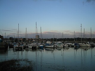
Fareham is a market town at the north-west tip of Portsmouth Harbour, between the cities of Portsmouth and Southampton in south east Hampshire, England. It gives its name to the Borough of Fareham. It was historically an important manufacturer of bricks, used to build the Royal Albert Hall, and grower of strawberries and other seasonal fruits.

<span class="mw-page-title-main">Portchester</span> Human settlement in England

Portchester is a village in the Borough of Fareham in Hampshire, England. It is 4 miles (6.4 km) northwest of Portsmouth and around 18 miles east of Southampton on the A27 road. Its population according to the 2011 United Kingdom census was 17,789.

<span class="mw-page-title-main">Borough of Fareham</span> Non-metropolitan borough in England

The Borough of Fareham is a local government district with borough status in Hampshire, England. Its council is based in Fareham. Other places within the borough include Portchester, Hill Head, Sarisbury, Stubbington, Titchfield and Warsash. The borough covers much of the semi-urban area between the cities of Southampton and Portsmouth, and is part of the South Hampshire conurbation. The neighbouring districts are Eastleigh, Winchester, Portsmouth and Gosport. The district's southern boundary is the coast of the Solent.

<span class="mw-page-title-main">Hill Head</span>

Hill Head is a residential area and village on the coast of the Solent. It is located south of Stubbington, west of Lee-on-the-Solent and south east of Titchfield, in the borough of Fareham, Hampshire. Hill Head is in the Gosport parliamentary constituency. The MP is Caroline Dinenage of the Conservative party since 2010. Hill Head has a sandy beach with sailing, windsurfing, kitesurfing and fishing being the most popular pastimes upon its shores. There is also a small harbour, located where the River Meon enters the Solent. It is next to Titchfield Haven National Nature Reserve.

Stubbington is a village which is located between Southampton and Portsmouth, in the county of Hampshire on the south coast of England. It is within the borough of Fareham.

<span class="mw-page-title-main">River Meon</span> River in Hampshire, England

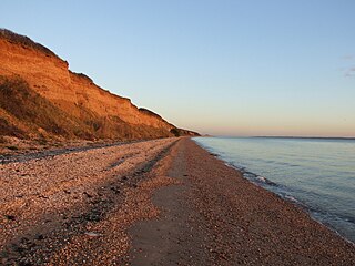
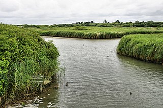
The River Meon is a chalk stream in Hampshire in the south of England. It rises at East Meon then flows 34 km (21 mi) in a generally southerly direction to empty into the Solent at Hill Head near Stubbington. Above Wickham, the river runs through the South Downs National Park.

<span class="mw-page-title-main">Hedge End</span> Human settlement in England

Hedge End is a town and civil parish in Hampshire, England. Situated to the east of the City of Southampton, it adjoins the districts of West End and Botley. Hedge End lies within the Borough of Eastleigh and is part of the Southampton Urban Area. The original hamlet developed on Botley Common after 1250 when it was granted to the men of Botley as common pasture. In 1267, royal charters allowed Botley to hold an annual fair and a weekly market on the common which eventually became a market town.

<span class="mw-page-title-main">Bursledon</span> Human settlement in England

Bursledon is a village on the River Hamble in Hampshire, England. It is located within the borough of Eastleigh. Close to the city of Southampton, Bursledon has a railway station, a marina, dockyards and the Bursledon Windmill. Nearby villages include Swanwick, Hamble-le-Rice, Netley and Sarisbury Green.

Catisfield is an area of Fareham, Hampshire, England. Originally a small village in its own right, it has now merged with the western edge of the town.

<span class="mw-page-title-main">Funtley</span> Human settlement in England

Funtley – from the Anglo-Saxon, "Funtaleg", "spring field (clearing)", is a hamlet or exurb north of Fareham, Hampshire, England. It forms a projection towards the South Downs National Park and is generally included within Fareham's population as it is within its built-up area. At present the village is unparished, as the creation of a parish council was rejected by Fareham Borough Council, despite having the support of the majority of residents.

<span class="mw-page-title-main">Titchfield Abbey</span>

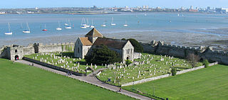
Titchfield Abbey is a medieval abbey and later country house, located in the village of Titchfield near Fareham in Hampshire, England. The abbey was founded in 1222 for Premonstratensian canons, an austere order of priests. The abbey was a minor house of its order, and became neither wealthy nor influential during its three centuries of monastic life; the inhabitants were devoted to scholarship, as shown by their very impressive library.

<span class="mw-page-title-main">West Meon</span> Human settlement in England

West Meon is a village and civil parish in Hampshire, England, with a population of 749 people at the 2011 census.

<span class="mw-page-title-main">Titchfield Canal</span> Channel in UK

<span class="mw-page-title-main">Sarisbury</span> Human settlement in England

Sarisbury is a village to the west of Park Gate within the borough of Fareham, Hampshire, in the south of England. Its focal point is Sarisbury Green and the parish church of St Paul, formerly part of Titchfield parish. In previous times it was a rural locality dependent on fruit growing. At the 2011 Census the population of the ward was 7,385. Nearby villages include Bursledon, Hamble-le-Rice and Swanwick. The name is pronounced 'Sarsbury' with the 'i' being silent.

<span class="mw-page-title-main">Warnford</span> Human settlement in England

Warnford is a village and civil parish in the City of Winchester district of Hampshire, England. The parish covers 1283 hectares. The village lies on the A32 in the upper valley of the River Meon between West Meon and Exton. The population in 2019 was estimated at 220. The village is rural in character, with most of the buildings along River Lane, Lippen Lane and Hayden Lane.

<span class="mw-page-title-main">Titchfield Haven</span>

Titchfield Haven is a 134.5-hectare (332-acre) biological Site of Special Scientific Interest north-west of Gosport in Hampshire. Most of it is a local nature reserve and a national nature reserve. It is part of Solent and Southampton Water Ramsar site and Special Protection Area.

References

  1. "Fareham Ward population 2011". Neighbourhood Statistics. Office for National Statistics. Retrieved 21 January 2017.
  2. 1 2 3 Fareham Borough Council: Titchfield. Accessed 26-11-08
  3. Titchfield Haven Nature Reserve, Accessed 26-11-08
  4. Kilpatrick, Kelly. "Saxons in the Meon Valley: A Place-Name Survey" (PDF). Saxons in the Meon Valley. Retrieved 8 March 2017.
  5. 1 2 3 4 5 6 Local Histories: Titchfield, Accessed 26-11-08
  6. Kilpatrick, Kelly. "Saxons in the Meon Valley: A Place-Name Survey" (PDF). Saxons in the Meon Valley. Retrieved 8 March 2017.
  7. St Peter's Church, Titchfield Archived 9 October 2011 at the Wayback Machine , Accessed 26-11-08
  8. "Askew, Anne".
  9. 1 2 Titchfield Parish History Society Archived 13 May 2008 at the Wayback Machine , Accessed 26-11-08
  10. "Plea Rolls of the Court of Common Pleas; CP 40 / 677, in 1430, 4th entry" . Retrieved 21 August 2021.
  11. "Population statistics Titchfield CP/AP through time". A Vision of Britain through Time . Retrieved 23 May 2023.
  12. "Relationships and changes Titchfield CP/AP through time". A Vision of Britain through Time. Retrieved 23 May 2023.
  13. 1 2 Doubleday and Page, Houses of Cistercian monks: Abbey of Netley, A History of the County of Hampshire: Volume II. The Victoria County History, 1973.
  14. Fareham Borough Council - Titchfield Abbey Archived 24 October 2007 at the Wayback Machine , Accessed 26-11-08
  15. The Bugle Hotel Website Archived 12 October 2008 at the Wayback Machine . Accessed 26-11-08
  16. English Heritage: Titchfield Abbey. Accessed 26-11-08
  17. Roberts, Edward; Crook, John (2003). "True Aisled and Aisle-Derivative Halls in Hampshire". Hampshire Houses 1250-1700: Their Dating and Development. Hampshire County Council. p. 4. ISBN   1859756336.
  18. Titihfield Office Directions, Office for National Statistics (ONS), [ dead link ] Accessed 26-11-08
  19. Titchfield office briefing memo, Office for National Statistics (ONS) Archived 5 June 2011 at the Wayback Machine , Accessed 26-11-08
  20. Daily Echo News - Titchfield Carnival now over. Accessed 26-11-08