
The Cotswolds is a region in central-southwest England, along a range of rolling hills that rise from the meadows of the upper Thames to an escarpment above the Severn Valley and Evesham Vale.

Stroud is a market town and civil parish in Gloucestershire, England. It is the main town in Stroud District. The town's population was 13,500 in 2021.

Lechlade is a town at the southern edge of the Cotswolds in Gloucestershire, England, 55 miles (89 km) south of Birmingham and 68 miles (109 km) west of London. It is the highest point at which the River Thames is navigable, although there is a right of navigation that continues south-west into Cricklade, in the neighbouring county of Wiltshire. The town is named after the River Leach that joins the Thames near the Trout Inn and St. John's Bridge.
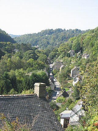
Chalford is a large village in the Frome Valley of the Cotswolds in Gloucestershire, England. It is to the southeast of Stroud about four miles upstream. It gives its name to Chalford parish, which covers the villages of Chalford, Chalford Hill, France Lynch, Bussage and Brownshill, spread over two square miles of the Cotswold countryside. At this point the valley is also called the Golden Valley.

Bisley is a village and former civil parish, now in the parish of Bisley-with-Lypiatt, in the Stroud district, in Gloucestershire, England, about 4 miles (6 km) east of Stroud. The once-extensive manor included Stroud and Chalford, Thrupp, Oakridge, Bussage, Througham and Eastcombe. In 1891 the parish had a population of 5171.
Winstone is a village and civil parish in the English county of Gloucestershire. The population taken at the 2011 census was 270.

Arlingham is a village and civil parish in the Stroud District of Gloucestershire, England. The 2001 Census recorded a parish population of 410, increasing to 459 at the 2011 census. The parish contains the hamlets of Milton End, Overton and Priding. The next parish to the east is Fretherne with Saul.
Horsley is a village and civil parish about one and a half miles south-west of the small Cotswold market town of Nailsworth. The origins of the name Horsley are much debated, although it is thought to be derived from the pre-7th-century Old English phrase, "horse-lega", meaning "place of horses".

Woodchester Mansion is an unfinished, Gothic revival mansion house in Nympsfield, Gloucestershire, England. It is on the site of an earlier house known as Spring Park. The mansion is a Grade I listed building.

Great Barrington is a village and former civil parish, now in the parish of Barrington, in the Cotswold district of Gloucestershire, England. It lies in the north bank of the River Windrush, 3 miles (4.8 km) west of the town of Burford, Oxfordshire. In 1931 the parish had a population of 330.

Frampton Mansell is a small English village 5 miles east-south-east of Stroud, Gloucestershire, in the parish of Sapperton. It lies off the A419 road between Stroud and Cirencester. It has a prominent mid-19th century, Grade II listed church with a set of five original stained-glass windows.

Daylesford is a small, privately owned village and former civil parish, now in the parish of Adlestrop, in the Cotswold district, in the county of Gloucestershire, England, on the border with Oxfordshire. It is situated just south of the A436 two miles east of Stow-on-the-Wold and five miles west of Chipping Norton. The village is on the north bank of the small River Evenlode. This area falls within the Cotswold Hills Area of Outstanding Natural Beauty, so designated in 1966. In 1931 the parish had a population of 82.

Lypiatt Park is a medieval and Tudor manor house with notable nineteenth-century additions in the parish of Bisley, near Stroud, in Gloucestershire, England. The grounds include a fine group of medieval outbuildings. It is a Grade I listed building.

Gloucestershire Victoria County History is an encyclopaedic history of the county of Gloucestershire in England. It forms part of the overall Victoria County History of England founded in 1899 in honour of Queen Victoria. With twelve volumes published in the series A History of the County of Gloucestershire, the Gloucestershire Victoria County History is about halfway through its history of all the parishes in the county. Ten volumes have been published to date, and a further four volumes are in preparation.

Lasborough is a settlement in Gloucestershire, England, part of the Westonbirt with Lasborough civil parish. Lasborough lies to the west of the A46, about two miles north of Leighterton, two miles south of Kingscote and five miles west of Tetbury.

Painswick House is a grade I listed house in Painswick, Gloucestershire, England. It is surrounded by a Grade II* listed rococo garden.
The Court House is a grade I listed house in Hale Lane, Painswick, Gloucestershire, England, within the Cotswolds.
John Tame of Cirencester and of Beauchamp Court in the parish of Fairford, both in Gloucestershire, England, was a wealthy wool producer and merchant who re-built the surviving St. Mary's Church, Fairford, the former structure of which had been built by one of the Beauchamp Earls of Warwick in the 15th century. The 28 Fairford stained glass windows he installed in the church are considered amongst the finest and most complete in England. He and his son Sir Edmund Tame (d.1534) so fostered the trade transacted at Fairford, that it came to rival that of the nearby long-established town of Cirencester, which increase was remarked upon by his contemporary the antiquary John Leland (d.1552): "Fairford never flourished afore the cumming of the Tames into it".
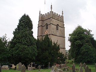
The Anglican Church of the Holy Cross at Avening in the Cotswold District of Gloucestershire, England was built in late 11th century. It is a grade I listed building.
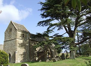
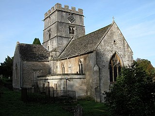
The Anglican Church of St Bartholomew at Winstone in the Cotswold District of Gloucestershire, England was built in the 11th century. It is a grade I listed building.
