
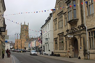
Cirencester is a market town and civil parish in the Cotswold District of Gloucestershire, England. Cirencester lies on the River Churn, a tributary of the River Thames. It is the eighth largest settlement in Gloucestershire and the largest town within the Cotswolds. It is the home of the Royal Agricultural University, the oldest agricultural college in the English-speaking world, founded in 1840. The town had a population of 20,229 in 2021. The town is 18 miles (29 km) northwest of Swindon, 18 miles (29 km) southeast of Gloucester, 37 miles (60 km) west of Oxford and 39 miles (63 km) northeast of Bristol.
Cotswold is a local government district in Gloucestershire, England. It is named after the wider Cotswolds region and range of hills. The council is based in the district's largest town of Cirencester. The district also includes the towns of Chipping Campden, Fairford, Lechlade, Moreton-in-Marsh, Northleach, Stow-on-the-Wold and Tetbury, along with numerous villages and surrounding rural areas.

Stroud District is a local government district in Gloucestershire, England. The district is named after its largest town of Stroud. The council is based at Ebley Mill in Cainscross. The district also includes the towns of Berkeley, Dursley, Nailsworth, Stonehouse and Wotton-under-Edge, along with numerous villages and surrounding rural areas. Over half of the district lies within the Cotswolds Area of Outstanding Natural Beauty.
Avonmouth is a port and outer suburb of Bristol, England, on the north bank of the mouth of the River Avon and the eastern shore of the Severn Estuary. Part of the Port of Bristol, Avonmouth Docks is important to the region's maritime economy, hosting large vessels for the unloading and exporting of heavier goods. Much of the land use is industrial, including warehousing, light industry, electrical power and sanitation. The M5 motorway bisects the neighbourhood, with junctions onto the A4 road and M49 motorway, and it has stations on the Severn Beach Line railway.
Kemble is a village in the civil parish of Kemble and Ewen, in the Cotswold district of Gloucestershire, England. Historically part of Wiltshire, it lies 4 miles (6.4 km) from Cirencester and is the settlement closest to Thames Head, the source of the River Thames. In 2020 it had an estimated population of 940. At the 2011 census the parish had a population of 1,036.
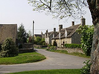
Dyrham is a village and parish in South Gloucestershire, England.
Dodington is a village and civil parish in South Gloucestershire, England. The village lies in a small, fertile valley between Codrington and Old Sodbury, and runs together with the even tinier hamlet of Coombes End. It is about 2.5 miles southeast of Chipping Sodbury and four miles from Yate railway station.

Horton is a village and civil parish on the Cotswold Edge, in the South Gloucestershire district, in the ceremonial county of Gloucestershire, England. It is about 2+1⁄2 miles (4.0 km) north of Chipping Sodbury. The nearest settlement is Little Sodbury, about 1+1⁄2 miles (2.4 km) away; Hawkesbury Upton and Dunkirk are both 2+1⁄2 miles (4.0 km) miles away. It is a linear settlement built on the slopes of a steep hill. In 2011 the parish had a population of 355. On 1 April 2023 the parish of Little Sodbury was merged with Horton.

South Cerney is a village and civil parish in the Cotswold district of Gloucestershire, 3 miles south of Cirencester and close to the border with Wiltshire.
Cotswold District Council in Gloucestershire, England, is elected every four years.

Leighterton is a village in rural Gloucestershire off the A46. It sits within the civil parish of Boxwell with Leighterton, 4.25 miles west-southwest of Tetbury, towards the southern end of the Cotswolds AONB. Situated in the Cotswold hills, it is 175 metres above sea level. Historically, it was situated within the hundred of Grumbald's Ash.
Hinton Blewett is a village and civil parish in Somerset, England, 5 miles (8.0 km) north of Wells and 15 miles (24.1 km) south of Bristol on the northern slope of the Mendip Hills, within the designated Area of Outstanding Natural Beauty (AONB) and in the Chew Valley near the source of the River Chew. The parish has a population of 308.

Coln St Aldwyns is a village and civil parish in the Cotswold district of the English county of Gloucestershire.
Meysey Hampton is a village and civil parish in Gloucestershire, England, approximately 30 miles (48 km) to the south-east of Gloucester. It lies in the south of the Cotswolds, an Area of Outstanding Natural Beauty.
Cold Aston is a village and civil parish in Gloucestershire, England, approximately 18 miles (29 km) to the east of Gloucester. It lies in the Cotswolds, an Area of Outstanding Natural Beauty. In the 2011 census, the population was 255.

Duntisbourne Rouse is a village and civil parish in Gloucestershire, England. It lies in the Cotswolds, an Area of Outstanding Natural Beauty. At the 2001 census, it had a population of 70.

Notgrove is a village and civil parish in Gloucestershire, England, approximately 28.5 to the east of Gloucester. It lies in the Cotswolds, a previously-named Area of Outstanding Natural Beauty, now the Cotswolds National Landscape.

North Cerney is a village and civil parish in the English county of Gloucestershire, and lies within the Cotswolds, a range of hills designated an Area of Outstanding Natural Beauty. The village is 4 miles (6.4 km) north of Cirencester within the Churn Valley.

Grumbald's Ash Hundred was a subdivision of the county of Gloucestershire, England. Hundreds originated in the late Saxon period and lasted as administrative divisions until the 19th century. It has been reported that the court was originally held under an Ash tree situated in Doddington parish, although this location would not be consistent with the previous split of hundred. Its name survives in the Grumbolds Ash with Avening electoral ward of Cotswold district council.

Nailsworth Stream is a small river in Gloucestershire, England. It is a tributary of the River Frome. From its source near Cherington, it flows westwards through Avening to reach Nailsworth, where it turns towards the north, and passes through Woodchester to join the Frome at Dudbridge, a suburb of Stroud.


