Tintern Wireworks Branch

Last updated

Tintern Wireworks Branch
BSicon exCONTgq.svg
BSicon exABZq+l.svg
BSicon exCONTfq.svg
BSicon dWASSERq.svg
BSicon exhKRZWae+GRZq.svg
BSicon dWASSERq.svg
River Wye
England
Wales
BSicon exKBST2.svg
BSicon exSTR+c3.svg
Sidings
BSicon exSTRc1.svg
BSicon exABZg+4.svg
BSicon exSKRZ-Mo.svg
BSicon exKDSTe.svg
Abbey Tinplate Works
The bridge that carried the branch over the River Wye. TinternWireworksBridge.JPG
The bridge that carried the branch over the River Wye.

The Tintern Wireworks Branch was a short branch line on the Wye Valley Railway, crossing the River Wye between Monmouthshire, Wales, and Gloucestershire, England. It was completed in 1874 and opened on 1 November 1876; the reason for the delay was that the Wye Valley Railway, into which the branch line fed, was not completed until the latter date. It closed in 1935 when the rails buckled in the heat of the summer. [1]

Contents

The bridge that carried the line over the Wye, known as the Tintern Wireworks Bridge or Old Tramway Bridge, is now used as a footpath, [2] but in 2022 and 2023 has been temporarily closed for repair.

History

Wye Valley Amendment Act

In 1866 the Wye Valley Railway Company announced that it would not build a line through the village of Tintern, but by-pass it. To make up for this the company was forced to build a branch to the wireworks on the other side of Tintern. The Wye Valley Amendment Act was passed on 14 June 1875 stating that the company would forever maintain the branch and junction in good repair; as well as setting the regulations on running the line. [1] The line was designed out by the engineering firm, S. H. Yockney, of London, [lower-alpha 1] [4] and the construction works were carried out by the Isca Foundry Co. of Newport. [5]

Abbey Wire and Tinplate Company

By August 1875, before the opening of the branch, the Abbey Wireworks Company had stopped trading. The line remained practically empty until the early 1880s when the works were taken over by the Abbey Wire and Tinplate Company; this venture was short lived and the works closed in 1901. The privately owned locomotive was sold and from then on the branch was only used by horses for the sawmills and turnery works in the village. [1]

Closure

The line closed in 1935. Most of the tracks were lifted in 1941 and sent for scrap. [6] [7] [8] The junction with the Wye Valley Railway was lifted in 1945 and was the last part of the branch to be lifted. The weigh house on the line survived until the late 1970s. [1]

Tintern Wireworks Bridge

The bridge carrying the branch over the Wye today carries a public footpath. It is known as the Tintern Wireworks Bridge [9] or the Old Tramway Bridge. [10] John Newman, in his Gwent/Monmouthshire volume of the Pevsner Buildings of Wales, notes the bridge's "three steel-truss spans on two high, rock-faced, piers." [11]

Heritage status

The bridge is a Grade II listed structure and has two listings, as is often the case with bridges that cross county borders; in this case, a Welsh designation by Cadw for the section in Monmouthshire, [10] and an English designation by Historic England for the section in Gloucestershire. [12]

Restoration in 2022/23

An assessment of the bridge undertaken in 2021 by Gloucestershire County Council found its condition to be unsafe due to severe corrosion, and the bridge was closed to all vehicular traffic in October 2021. [9] A restoration, costing £1.5M, began in 2022.[ citation needed ] The bridge has been closed to all traffic, including pedestrians, from late June 2022. The restoration work will include removal of the timber deck and its replacement with a steel deck; strengthening of the structure, including the installation of new box beams; grit blasting and painting; and repointing the masonry supports. [9] It is anticipated that the bridge will be re-opened by 26 May. [13]

The bridge featured as a setting in Episode 1.2 of the 2019 Netflix comedy drama series Sex Education . [14] [15]

Notes

  1. Samuel Hansard Yockley, the founder of S. H. Yockley, undertook much work in Wales and the West of England, including for Isambard Kingdom Brunel on the Great Western Railway. [3]

Related Research Articles

<span class="mw-page-title-main">Tintern Abbey</span> Abbey in Tintern, Monmouthshire

Tintern Abbey was founded on 9 May 1131 by Walter de Clare, Lord of Chepstow. It is situated adjacent to the village of Tintern in Monmouthshire, on the Welsh bank of the River Wye, which at this location forms the border between Monmouthshire in Wales and Gloucestershire in England. It was the first Cistercian foundation in Wales, and only the second in Britain.

<span class="mw-page-title-main">Chepstow</span> Human settlement in Wales

Chepstow is a town and community in Monmouthshire, Wales, adjoining the border with Gloucestershire, England. It is located on the tidal River Wye, about 2 miles (3.2 km) above its confluence with the River Severn, and adjoining the western end of the Severn Bridge. It is the easternmost settlement in Wales, situated 16 miles (26 km) east of Newport, 28 miles (45 km) east-northeast of Cardiff, 18 miles (29 km) northwest of Bristol and 110 miles (180 km) west of London.

<span class="mw-page-title-main">Monmouthshire</span> County in Wales

Monmouthshire is a county in the south-east of Wales. The name derives from the historic county of the same name; the modern county covers the eastern three-fifths of the historic county. The largest town is Abergavenny, with other towns and large villages being: Caldicot, Chepstow, Monmouth, Magor and Usk. It borders Torfaen, Newport and Blaenau Gwent to the west; Herefordshire and Gloucestershire to the east; and Powys to the north.

<span class="mw-page-title-main">Monmouthshire (historic)</span> Historic county in Wales

Monmouthshire, also known as the County of Monmouth, is one of thirteen historic counties of Wales and a former administrative county. It corresponds approximately to the present principal areas of Monmouthshire, Blaenau Gwent, Newport and Torfaen, and those parts of Caerphilly and Cardiff east of the Rhymney River.

<span class="mw-page-title-main">Tintern</span> Human settlement in Wales

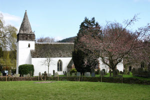
Tintern is a village in the community of Wye Valley, on the west bank of the River Wye in Monmouthshire, Wales, close to the border with England, about 5 miles (8.0 km) north of Chepstow. It is popular with tourists, in particular for the scenery and the ruined Tintern Abbey. Modern Tintern has been formed through the coalescence of two historic villages; Tintern Parva, forming the northern end of the village, and Chapel Hill, which forms the southern end. The village is designated as a Conservation Area.

<span class="mw-page-title-main">Chepstow Castle</span>

Chepstow Castle at Chepstow, Monmouthshire, Wales is the oldest surviving post-Roman stone fortification in Britain. Located above cliffs on the River Wye, construction began in 1067 under the instruction of the Norman Lord William FitzOsbern. Originally known as Striguil, it was the southernmost of a chain of castles built in the Welsh Marches, and with its attached lordship took the name of the adjoining market town in about the 14th century.

<span class="mw-page-title-main">Piercefield House</span> Neo-classical country house

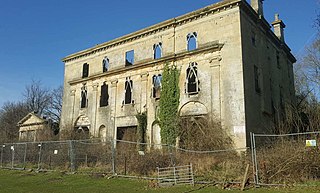
Piercefield House is a largely ruined neo-classical country house near St Arvans, Monmouthshire, Wales, about 1.5 miles (2.4 km) north of the centre of Chepstow. The central block of the house was designed in the very late 18th century, by, or to the designs of, Sir John Soane. It is flanked by two pavilions, of slightly later date, by Joseph Bonomi the Elder. The house sits within Piercefield Park, a Grade I listed historic landscape, that was created in the 18th century as a notable Picturesque estate.

<span class="mw-page-title-main">Tidenham</span> Human settlement in England

Tidenham is a village and civil parish in the Forest of Dean of west Gloucestershire, England, adjoining the Welsh border. Tidenham is bounded by the River Wye to the west and the River Severn to the south. Offa's Dyke runs through the western part of the parish, terminating at Sedbury cliff above the River Severn.

<span class="mw-page-title-main">Llandogo</span> Human settlement in Wales

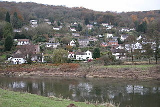
Llandogo is a small village in Monmouthshire, south Wales, between Monmouth and Chepstow in the lower reaches of the Wye Valley AONB, two miles north of Tintern. It is set on a steep hillside overlooking the River Wye and across into the Forest of Dean in Gloucestershire, England. The 2011 census population was 547.

<span class="mw-page-title-main">Wye Valley</span> Area of Outstanding Natural Beauty in England and Wales

The Wye Valley Area of Outstanding Natural Beauty is an internationally important protected landscape straddling the border between England and Wales.

<span class="mw-page-title-main">A466 road</span> Road in England and Wales

The A466, also known as the Wye Valley Road, is a road from Hereford, England to Chepstow, Wales via Monmouth, Tintern and the Wye Valley.

<span class="mw-page-title-main">Devauden</span> Human settlement in Wales

Devauden is a village and community in Monmouthshire, southeast Wales. It is located between Chepstow and Monmouth near the top of the Trellech ridge on the B4293 road. The community covers an area of 3,790 hectares (14.6 sq mi). The community includes the villages of Itton and Wolvesnewton, Llanfihangel-tor-y-mynydd and Newchurch.

<span class="mw-page-title-main">Whitebrook</span> Human settlement in Wales

Whitebrook is a small village in Monmouthshire, south-east Wales, United Kingdom. It is located four miles south east of Monmouth in the Wye Valley.

<span class="mw-page-title-main">Dixton</span> Human settlement in Wales

Dixton is a small village located 1 mile (1.6 km) north east of Monmouth, on the banks of the River Wye, in Monmouthshire, south east Wales. The parish originally comprised the two manors of Dixton Newton and Dixton Hadnock, on either side of the river.

<span class="mw-page-title-main">Llanishen, Monmouthshire</span> Human settlement in Wales

Llanishen is a village in Monmouthshire, south east Wales, United Kingdom. It is located 7 miles (11 km) south west of Monmouth and 3 miles (4.8 km) south of Trellech on the B4293 road, although the main part of the village is set immediately to the west of the road, overlooking the Vale of Usk.

<span class="mw-page-title-main">Wye Valley Railway</span> Disused railway in England and Wales

The Wye Valley Railway was a standard gauge railway that ran for nearly 15 miles (24 km) along the Lower Wye Valley between the towns of Chepstow and Monmouth, crossing several times between Wales and England. Opened on 1 November 1876, it was leased to, and worked by, the Great Western Railway (GWR), before being fully absorbed by the GWR in 1905.

<span class="mw-page-title-main">Old Wye Bridge, Chepstow</span> Bridge in Tutshill, Gloucestershire

The Old Wye Bridge or Town Bridge at Chepstow, also known historically as Chepstow Bridge, crosses the River Wye between Monmouthshire in Wales and Gloucestershire in England, close to Chepstow Castle. Although there had been earlier wooden bridges on the site since Norman times, the current road bridge was constructed of cast iron in 1816 during the Regency period, by John Rastrick of Bridgnorth, who greatly modified earlier plans by John Rennie.

<span class="mw-page-title-main">Grade I listed buildings in Monmouthshire</span>

Monmouthshire is a county and principal area of Wales. It borders Torfaen and Newport to the west; Herefordshire and Gloucestershire to the east; and Powys to the north. The largest town is Abergavenny, with the other major towns being Chepstow, Monmouth, and Usk. The county is 850 km2 in extent, with a population of 95,200 as of 2020. The present county was formed under the Local Government (Wales) Act 1994, which came into effect in 1996, and comprises some sixty percent of the historic county. Between 1974 and 1996, the county was known by the ancient title of Gwent, recalling the medieval Welsh kingdom. In his essay on local government in the fifth and final volume of the Gwent County History, Robert McCloy suggests that the governance of "no county in the United Kingdom in the twentieth century was so transformed as that of Monmouthshire".

<span class="mw-page-title-main">Redbrook Incline Bridge</span> Bridge in England / Monmouthshire, Wales

The Redbrook Incline Bridge is a nineteenth-century tramway bridge that crosses the B4231 road at Redbrook on the England–Wales border. The bridge straddles the border and stands in the counties of Monmouthshire in Wales and Gloucestershire in England. It was built as a branch line from the Monmouth Tramroad to transport coal to the Redbrook Tinplate Works and was constructed on a significant incline as a consequence of its standing well below the main tramway. It is a remarkable survival of 19th-century industrialisation in the Wye Valley and is both a Grade II* and a Grade II listed structure, and a scheduled monument.

References

  1. 1 2 3 4 B. M. Handley and R. Dingwall, The Wye Valley Railway and the Coleford Branch, 1982, ISBN   0-85361-530-6
  2. "Tintern Bridge: Old Tramway Bridge", HistoricBridges.org. Retrieved 30 March 2022
  3. "Samuel Hansard Yockley". Grace’s Guide to British Industrial History. Retrieved 30 March 2022.
  4. "Samuel Hansard Yockley". Grace’s Guide to British Industrial History. Retrieved 30 March 2022.
  5. "Wireworks Bridge". Forest of Dean Local History Society. Retrieved 30 March 2022.
  6. Nicholson, Gawain. "History of the line" . Retrieved 30 March 2022.
  7. Davis, J. J. "The Railways of Monmouth 1959" . Retrieved 30 March 2022.
  8. "Wye Valley AONB industrial heritage". Wye Valley AONB. Retrieved 30 March 2022.
  9. 1 2 3 "Tintern Wireworks Bridge improvements". Gloucestershire Highways. Retrieved 18 June 2022.
  10. 1 2 Cadw. "Old Tramway Bridge, Tintern (Grade II) (24033)". National Historic Assets of Wales . Retrieved 30 March 2022.
  11. John Newman, Gwent/Monmouthshire, The Buildings of Wales, 2000, Penguin, page 557, ISBN   0-14-071053-1
  12. Historic England. "Old Tramway Bridge (formerly Wireworks Bridge), Tintern (Grade II) (1393682)". National Heritage List for England . Retrieved 30 March 2022.
  13. "Bridge closure". Wye Valley Greenway.
  14. "Sex Education Tintern Wireworks Bridge to get upgrade". BBC News. 29 March 2022.
  15. IT, SCEEN. "Sex Education at Tintern - Wireworks Bridge - filming location". www.sceen-it.com.

Coordinates: 51°41′58″N2°40′53″W / 51.6994°N 2.6813°W / 51.6994; -2.6813