
Oxfordshire is a ceremonial county in South East England. The county is bordered by Northamptonshire and Warwickshire to the north, Buckinghamshire to the east, Berkshire to the south, and Wiltshire and Gloucestershire to the west. The city of Oxford is the largest settlement and county town.

West Oxfordshire is a local government district in northwest Oxfordshire, England, including towns such as Woodstock, Burford, Chipping Norton, Charlbury, Carterton and Witney, where the council is based.

Woodstock is a market town and civil parish, 8 miles (13 km) north-west of Oxford in West Oxfordshire in the county of Oxfordshire, England. The 2011 Census recorded a parish population of 3,100.
The Goring Gap is the narrow valley, occupied by the River Thames, between the Chiltern Hills and the Berkshire Downs. It is approximately 10 miles (16 km) upstream of Reading and 27 miles (43 km) downstream of Oxford. The river here delimits Berkshire from Oxfordshire. The village of Goring, on the Oxfordshire side of the Thames, gives its name to the gap.
The River Thame is a river in Southern England. A tributary of the River Thames, the river runs generally south-westward for about 40 mi (64 km) from its source above the Buckinghamshire town of Aylesbury to the Thames in south-east Oxfordshire.
Combe is a village and civil parish about 5 miles (8 km) northeast of Witney in Oxfordshire. It is bounded to the south and southwest by the River Evenlode, to the northwest partly by the course of the Akeman Street Roman road and partly by a road parallel with it, and to the east by the boundary of Blenheim Great Park. The 2011 Census recorded the parish's population as 768.

The River Evenlode is a tributary of the Thames in Oxfordshire. It rises near Moreton-in-Marsh, Gloucestershire, in the Cotswold Hills and flows south-east to the Thames, its valley providing the route of the southern part of the Cotswold Line. The river flows for 45 miles (72 km) from source to the River Thames.

Bladon is a village and civil parish on the River Glyme about 6+1⁄2 miles (10.5 km) northwest of Oxford, Oxfordshire, England. It is where Sir Winston Churchill is buried. The 2011 Census recorded the parish's population as 898.

The A4260 is a road that leads from the A422 Henneff Way, Banbury to Frieze Way near Oxford.
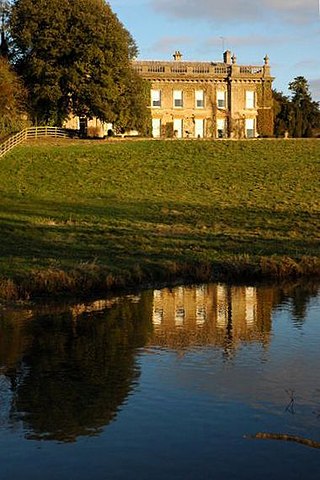
Glympton Park is a former deer park at Glympton, 3.5 miles (5.6 km) north of Woodstock, Oxfordshire, England. It includes Glympton House and has a 2,000 acres (810 ha) estate including the village of Glympton, its Norman parish church of St. Mary, 32 stone cottages and 167 acres (68 ha) of parkland.

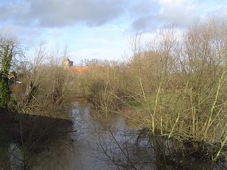
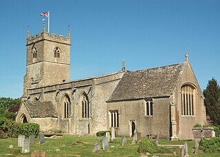
Glympton is a village and civil parish on the River Glyme about 3 miles (5 km) north of Woodstock, Oxfordshire. The 2001 Census recorded the parish's population as 80. The village and church are owned by the Glympton Park estate.

King's Lock is a lock on the River Thames in England. It is in open country to the north of Oxford, Oxfordshire, on the southern bank of the river. The lock was one of the last pound locks built on the Thames, built by the Thames Conservancy in 1928 to replace the former flash lock. It has the smallest fall of any lock on the river, 0.77 m.

Wootton is a village and civil parish on the River Glyme about 2 miles (3 km) north of Woodstock, Oxfordshire. In recent years the village is sometimes referred to as Wootton-by-Woodstock to distinguish it from Wootton, Vale of White Horse. The 2011 Census recorded the parish's population as 569.
The Oxfordshire Way is a long-distance walk in Oxfordshire, England, with 6 miles in Gloucestershire and very short sections in Buckinghamshire. The path links with the Heart of England Way and the Thames Path.

Glyme Valley is a 28.9-hectare (71-acre) biological Site of Special Scientific Interest east of Chipping Norton in Oxfordshire. An area of 3 hectares is a nature reserve managed by the Berkshire, Buckinghamshire and Oxfordshire Wildlife Trust

Kiddington is a village in the civil parish of Kiddington with Asterleigh, in the West Oxfordshire district, in the county of Oxfordshire, England. The village is on the River Glyme, just north of the A44 road between Woodstock and Chipping Norton, about 7 miles (11 km) southeast of Chipping Norton. In 1891 the parish had a population of 215. On 1 October 1895 the parish was abolished and nerged with Asterleigh to form "Kiddington with Asterleigh".

The Bell Inn, Long Hanborough is a well-established Grade II listedrestaurant and public house in the village of Long Hanborough, Oxfordshire, England.

The River Dorn is a river in Oxfordshire, England, that is a tributary of the River Glyme. The river rises from the limestone uplands of north Oxfordshire, about 1.5 miles (2.4 km) east of Chipping Norton (51.9587°N 1.4823°W), and flows southeast past Little Tew; through Sandford St. Martin, where it forms part of Sandford Park's gardens; and through the Bartons: Westcott Barton, Middle Barton, where Cockley Brook joins it, and Steeple Barton — before it joins the River Glyme just east of Wootton (51.8710°N 1.3554°W).

Gagingwell is a hamlet in West Oxfordshire, about 6 miles (10 km) east of Chipping Norton and about 1.8 miles (3 km) east of Enstone. The hamlet surrounds a group of springs that give rise to a brook, which flows southwards almost 1 mile (1.6 km) to join the River Glyme just downstream of the hamlet of Radford.
Kiddington Hall is a large Grade II listed manor house located in Kiddington, near Woodstock, Oxfordshire, England.

