Denbigh, Milton Keynes

Last updated

Denbigh
Location map United Kingdom Milton Keynes.png
Red pog.svg
Denbigh
Mapping © OpenStreetMap
Buckinghamshire UK location map.svg
Red pog.svg
Denbigh
Location within Buckinghamshire
OS grid reference SP874347
Civil parish
  • Bletchley and Fenny Stratford
Unitary authority
Ceremonial county
Region
Country England
Sovereign state United Kingdom
Post town MILTON KEYNES
Postcode district MK1
Dialling code 01908
Police Thames Valley
Fire Buckinghamshire
Ambulance South Central
UK Parliament
List of places
UK
England
Buckinghamshire
52°00′15″N0°43′36″W / 52.0043°N 0.7268°W / 52.0043; -0.7268

Denbigh is a district in Milton Keynes, Buckinghamshire, England, to the north of Fenny Stratford and on the eastern side of the West Coast Main Line (and on the opposite side to the rest of Bletchley). It is in the civil parish of Bletchley and Fenny Stratford [1] and is categorised by the Office for National Statistics as part of the Bletchley built-up area. [lower-alpha 1] The A5 forms its eastern and northern boundary; parts of Bletcham Way and Saxon St form its southern boundary. The overall district has five sub districts, divided by Watling St/Denbigh Rd, the 'uptick' of Bletcham Way and Grafton Street, and Saxon Street northbound. The district names are planning designations that have persisted without ever being changed to the style "North Denbigh" etc. as is the norm elsewhere in Britain.

Contents

These lands to the east of Watling Street were originally in the manor of Simpson. [3]

Denbigh North

The East Stand of the 30,000 seater Stadium mk Denbigh stadium east stand 16 May 07.JPG
The East Stand of the 30,000 seater Stadium mk

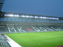
This district, next to the junction of the A5 with the A421, includes the 30,500 all-seater Stadium MK for Milton Keynes Dons F.C. as well as a hotel and retail outlets.

The football stadium opened in July 2007 and was ready for the start of the 2007/08 season. An indoor basketball arena for the then Milton Keynes Lions basketball team was planned as part of the stadium complex but as of mid-2014 has yet to materialise.

The major retailers are an Asda supercentre and IKEA superstore, with smaller shops in the MK1 Shopping Park. The superstores were open for business by the end of 2005.

The first units of the MK1 Shopping Park, constructed later of the Asda and IKEA development, include a McDonald's and KFC on the Saxon Street side of the stadium, with a DW Sports Fitness centre on the Grafton Street side of the stadium.

The main retail centre of the MK1 Shopping Park opened in December 2012, which comprises Marks and Spencer, Outfit (previously BHS), H&M, New Look, Next, Primark and River Island which opened sites in the shopping park. The latter was developed adjacent to Stadium MK by InterMK and The Crown Estate. [4] InterMK is owned by Pete Winkelman, chairman of the MK Dons. [4]

The development also includes a newer leisure facility and cinema complex directly behind the stadium, comprising an Odeon IMAX Cinema, Nandos, Bella Italia, TGI Fridays, Prezzo and Frankie and Benny's which opened in late February/early March 2015. [5]

The MK1 Shopping Park expanded once again, constructing a new five-unit development in the space between the original shopping park and the newer cinema complex. This comprises, at its opening, a JD Sports, Carphone Warehouse and Card Factory. This opened in early December 2017.

The hotel is a DoubleTree by Hilton Worldwide, part of the stadium complex.

The development is on the former site of 'Denbigh Sports Ground' and 'Denbigh North Leisure', an entertainment complex which was home to the Sanctuary Music Arena.

Denbigh West

Denbigh West is an employment area, best known as the home of Marshall Amplification. It is on the east side of Watling Street, west of Saxon Street..

Denbigh East

Denbigh East is another employment area, east of Saxon Street and west of the Grand Union canal.

Mount Farm

This district is an industrial/employment area. The Milton Keynes central sorting office was here, with the post-code MK1 1AA. Many internet mapping sites assumed that this meant that it is the centre of Milton Keynes and mark it according. It is actually about three miles south of Central Milton Keynes (which has the MK9 postcode).

Granby

This is a small area, just north of the stadium. It is mainly industrial, but includes a mosque and a small, isolated, council housing block (that is planned for regeneration in future Milton Keynes Council plans).

The district takes its name from the original 'Marquis of Granby" inn nearby, as described next.

Denbigh Hall

Inscription on Denbigh Hall railway bridge Denbigh Hall bridge inscription - 2013-03-09.jpg
Inscription on Denbigh Hall railway bridge

The modern industrial district called Denbigh Hall is in West Bletchley rather than in Denbigh, but is mentioned here because its history gives rise to the name Denbigh. A local heritage map shows that it lies on the site of 'Denbigh Farm' [6] It is separated from Denbigh by Watling Street.

The original Denbigh Hall was an inn on Watling Street, dating from 1710. [6] Family recollections say that it had previously been known as 'the Marquis of Granby' but that it had changed its name in the eighteenth century when the sixth Earl of Denbigh stopped there overnight and was made so comfortable that he declared it his half-way house to London. [7] [8] The inn no longer exists; its site is shown on the 1885 Ordnance Survey as just north of the bridge 158 where the West Coast Main Line crosses Watling Street. [9] A third tale relates that the nobleman was given an axe when he asked for a bill. [10] The same map shows a large private house, 'Denbigh Hall', to the south-east of the inn its site is approximately at the junction of Whaddon Way with Melrose Avenue.

Network Rail continues to use this name (Denbigh Hall) for its marshalling yards north of Bletchley railway station, near the site of the inn. The West Coast Main Line bridge (number 158) over Watling Street near here bears a plaque that explains that the first phase of the London and Birmingham Railway line terminated here, at Denbigh Hall station. At this point, passengers transferred to stage coaches for onward transfer by road to Birmingham. [11]

See also

Notes

  1. The Bletchley built-up sub-area is that part of Milton Keynes that is west of the A5 and south of the A421. [2]

Related Research Articles

<span class="mw-page-title-main">Milton Keynes</span> City in Buckinghamshire, England

Milton Keynes is a city in Buckinghamshire, England, about 50 miles (80 km) north-west of London. At the 2021 Census, the population of its urban area was 264,349. The River Great Ouse forms the northern boundary of the urban area; a tributary, the River Ouzel, meanders through its linear parks and balancing lakes. Approximately 25% of the urban area is parkland or woodland and includes two Sites of Special Scientific Interest (SSSIs).

<span class="mw-page-title-main">City of Milton Keynes</span> Unitary authority area in England

The City of Milton Keynes is a unitary authority area with both borough and city status, in Buckinghamshire. It is the northernmost district of the South East England Region. The borough abuts Bedfordshire, Northamptonshire and the remainder of Buckinghamshire.

<span class="mw-page-title-main">Bletchley</span> Human settlement in England

Bletchley is a constituent town of Milton Keynes, Buckinghamshire, England. It is situated in the south-west of the city, and is split between the civil parishes of Bletchley and Fenny Stratford and West Bletchley. In 2011, the two parishes had a combined population of 37,114.

<span class="mw-page-title-main">Fenny Stratford</span> Human settlement in England

Fenny Stratford is a constituent town of Milton Keynes, Buckinghamshire, England and in the civil parish of Bletchley and Fenny Stratford. Originally an independent town, it was included in the Milton Keynes "designated area" in 1967. From 1895 it formed an urban district with Bletchley, until 1974 when it became part of the (then) District of Milton Keynes. It is located at the southern edge of the city, just east of Bletchley and west of the A5.

<span class="mw-page-title-main">Shenley Church End</span> Civil parish in Milton Keynes, England

Shenley Church End is a village, district and wider civil parish in Milton Keynes, Buckinghamshire, England, about 2 miles (3.2 km) south-west of Central Milton Keynes, and the same distance north-west of Bletchley. Together with its neighbouring districts of Shenley Brook End, Shenley Wood and Shenley Lodge, the districts are collectively known as "The Shenleys".

<span class="mw-page-title-main">Stony Stratford</span> Town and civil parish in Milton Keynes, England

Stony Stratford is a constituent town of Milton Keynes, Buckinghamshire, England. Historically it was a market town on the important route from London to Chester. It is also the name of a civil parish with a town council in the City of Milton Keynes. It is in the north-west corner of the Milton Keynes urban area, bordering Northamptonshire and separated from it by the River Great Ouse.

<span class="mw-page-title-main">Wolverton</span> Human settlement in England

Wolverton is a constituent town of Milton Keynes, England. It is located in the north-west of the city, beside the West Coast Main Line, the Grand Union Canal and the river Great Ouse. It is the administrative seat of Wolverton and Greenleys civil parish.

<span class="mw-page-title-main">Fenny Stratford railway station</span> Grade II listed station in Milton Keynes, England

Fenny Stratford is a railway station that serves the Fenny Stratford area of Milton Keynes, Buckinghamshire. It is on the Marston Vale Line that links Bletchley and Bedford, about one mile east of Bletchley railway station.

<span class="mw-page-title-main">Bletchley railway station</span> Railway station in Milton Keynes, England

Bletchleyrailway station serves the southern parts of Milton Keynes, England, and the north-eastern parts of Aylesbury Vale. It is 47 miles (76 km) northwest of Euston, about 32 miles (51 km) east of Oxford and 17 miles (27 km) west of Bedford, and is one of the seven railway stations serving the Milton Keynes urban area.

<span class="mw-page-title-main">Milton Keynes Central railway station</span> Principal railway station of Milton Keynes, England

Milton Keynes Central railway station serves Milton Keynes and surrounding parts of Bedfordshire, Buckinghamshire and Northamptonshire (England). The station is located on the West Coast Main Line about 50 miles (80 km) northwest of London. The station is served by Avanti West Coast intercity services, and by West Midlands Trains regional services.

<span class="mw-page-title-main">Wolverton railway station</span> Railway station in Milton Keynes, England

Wolverton railway station serves Wolverton, a constituent town of Milton Keynes, Buckinghamshire, England. The station is on the West Coast Main Line, about 52 miles (84 km) from Euston, between Milton Keynes Central and Northampton. The station is one of the seven stations serving the Milton Keynes urban area.

<span class="mw-page-title-main">Central Milton Keynes</span> Civil parish and central business district of Milton Keynes, England

Central Milton Keynes is the central business district of Milton Keynes, Buckinghamshire, England and a civil parish in its own right, with a town council.

Bletchley and Fenny Stratford is a civil parish with a town council, in Milton Keynes, Buckinghamshire, England. It was formed in 2001 from the unparished area of Milton Keynes, and according to the 2011 census had a population of 15,313. Together with West Bletchley, it forms the Bletchley built-up area.

Sport in Milton Keynes covers a range of professional and amateur sport in the City of Milton Keynes unitary authority area. In 2019, Milton Keynes was officially designated as a European City of Sport for 2020. There are professional teams in football, in motorsport and in ice hockey. The National Badminton Centre, and the Marshall Milton Keynes Athletic Club train professional and amateur athletes. Most other sports feature at amateur level although there are semi-professional teams in rugby union and football among other sports. There is an international-standard karting track owned by Daytona Motorsport.

<span class="mw-page-title-main">History of Milton Keynes</span> History of the city in England

This history of Milton Keynes details its development from the earliest human settlements, through the plans for a 'new city' for 250,000 people in northern Southeast England, its subsequent urban design and development, to the present day. Milton Keynes, founded in 1967, is the largest settlement and only city in Buckinghamshire. At the 2021 census, the population of its urban area was estimated to have exceeded 256,000.

<span class="mw-page-title-main">Milton Keynes grid road system</span> Top layer of street hierarchy

The Milton Keynes grid road system is a network of predominantly national speed limit, fully landscaped routes that form the top layer of the street hierarchy for both private and public transport in Milton Keynes, Buckinghamshire. The system is unique in the United Kingdom for its innovative use of street hierarchy principles: the grid roads run in between districts rather than through them. This arrangement permits higher speed limits due to the absence of buildings close to the roads – although more recently some have been limited in part to 40 mph (64 km/h). The grid road system also serves an important purpose of discouraging through-traffic from travelling through neighborhoods and thus reduces traffic noise and pollution in pedestrian areas. Motor traffic is segregated from pedestrian and leisure cycling traffic, which uses the alternative Milton Keynes redway system. Almost all grid junctions are roundabouts, and the absence of traffic lights enables free and efficient movement of traffic.

Bletchley Urban District was an urban district covering the town of Bletchley in the administrative county of Buckinghamshire, England from 1911 to 1974. The district had been created in 1895 as Fenny Stratford Urban District, being renamed to Bletchley Urban District in 1911.

Milton Keynes City Council is the local authority for the City of Milton Keynes, a unitary authority in Buckinghamshire, England. Until 1 April 1997 it was a non-metropolitan district.

<span class="mw-page-title-main">Denbigh Hall railway station</span> Railway station in Milton Keynes, UK

Denbigh Hall railway station was a temporary terminus station on the London and Birmingham Railway in the Denbigh area of what is now Milton Keynes in Buckinghamshire, England. It was situated about 1 mile (1.6 km) north of Bletchley railway station, near a point where the railway crossed Watling Street. It was open for less than six months, between April and September 1838.

<span class="mw-page-title-main">Denbigh Hall railway bridge</span> Bridge in Milton Keynes, England

Denbigh Hall railway bridge carries the West Coast Main Line railway across Watling Street just north of Bletchley, Milton Keynes, in southern England. It dates from the opening of the London and Birmingham Railway in 1838 and was designed by Robert Stephenson though it has been heavily modified. It is a Grade II listed building.

References

  1. UK Census (2011). "Local Area Report – Bletchley and Fenny Stratford Parish (E04012176)". Nomis. Office for National Statistics.
  2. UK Census (2011). "Local Area Report – Bletchley BUSA (E35000902)". Nomis. Office for National Statistics.
  3. Historic towns project: Bletchley and Fenny Stratford [ permanent dead link ]  English Heritage 2009
  4. 1 2 Milton Keynes £25m complex to be funded by Crown Estate
  5. Crook, Charles. "MK1 Leisure Park development secures Crown funding". Citiblog MK. Archived from the original on 12 May 2014.
  6. 1 2 "Milton Keynes Heritage" (map) - English Partnerships 2004
  7. Earl of Denbigh (1821). "The passing of great English country houses". The North American review via archive.org. Forty-five miles from London on the Watling Street road, where it is spanned by the bridge carrying the main line of the London, Midland and Scottish Railway to the North, is a solitary little inn bearing the name of Denbigh Hall. How different are modern conditions from those prevailing when my old great-great-grandfather, the sixth Earl of Denbigh, who died in 1800, used to rumble slowly and uncomfortably along this road to London in his ponderous coach ! One day a wheel came off in the mud near this inn, then known as the "Marquis of Granby ", and, putting up there for the night, he was made so comfortable that he forthwith appointed it his half-way house to London, and the name was changed to its present one.
  8. Harper, Charles G (1902). "The story of "Denbigh Hall"". The Holyhead Road; the mail-coach road to Dublin. p. 171 via archive.org. Another contemporary says : " The building called ' Denbigh Hall,' respecting which the reader may have formed the same conception as ourselves, and imagined it to be the august mansion of some illustrious grandee, is nothing but a miserable hostelry of the lowest order, a paltry public-house, or 'Tom and Jerry shop,' as we heard an indignant fellow-traveller contemptuously style it, which has taken the liberty of assuming this magnificent appellation." Tradition described how this house, once called the " Marquis of Granby," had been resorted to by the Earl of Denbigh on one occasion when his carriage had broken down, and that he stayed the night under its roof, and was so grateful for the attentions of the host that he left some property to that fortunate man, who thereupon changed the name of his sign to the "Denbigh Hall." This, at any rate, was the story told when the London and Birmingham Railway was first opened. There were those who looked upon it as a myth invented for the amusement of travellers, and perhaps those sceptics were right, but let others who are not unwilling to believe the story, hug the apt reflection that so unusual a sign must have had an unusual origin ; and, so much being granted, let them go a little further and accept the legend as it is told. The little inn still stands by the wayside.
  9. Ordnance Survey (1885). "Buckinghamshire XV" (Map). OS Six-inch England and Wales, 1842-1952. 1:10,560. National Library of Scotland. Retrieved 27 August 2020.
  10. Thomas Roscoe assisted by Peter Lecount (1839). The London and Birmingham railway, with the home and country scenes on each side of the line. p. 78.
  11. "A short history of the L&NW railway at Rugby". Rugby Advertiser. 26 December 1908. 9 April 1838: The line from London to Denbigh Hall was opened to the public. -(Denbigh Hall is a little hamlet about two miles north of Bletchley station, and was no doubt selected for a temporary terminus as the Holyhead coach Road crossed the line at this spot.) Immense crowds of people assembled along the newly opened portion of the line to see the first train pass. The line between Birmingham and rugby was opened on the same day. Owing to the delay in finishing Kilsby tunnel and Roade cutting, the line between Rugby and Denbigh Hall is not completed: and the Company have therefore arranged with Messrs Horne and Chaplin, the coach proprietors, to convey passengers by road over the intervening 36 or 37 miles between the two places.