History of Buckinghamshire

Last updated
Ancient extent of Buckinghamshire EnglandBuckinghamshireTrad.png
Ancient extent of Buckinghamshire

Although the name Buckinghamshire is Anglo Saxon in origin meaning The district (scire) of Bucca's home (referring to Buckingham in the north of the county) the name has only been recorded since about the 12th century. The historic county itself has been in existence since it was a subdivision of the kingdom of Wessex in the 10th century. It was formed out of about 200 communities that could between them fund a castle in Buckingham, to defend against invading Danes.

Contents

Human settlement in pre-history

Reproductions of the Milton Keynes Hoard of Bronze Age torcs and bracelets MiltonKeynesHoard.JPG
Reproductions of the Milton Keynes Hoard of Bronze Age torcs and bracelets

Some of the places in Buckinghamshire date back much further than the Anglo-Saxon period. Aylesbury, for example, is known from archaeological digs to date back at least as far as 1500 B.C. and the Icknield Way, which crosses the county, is pre-Roman in origin. There are a wealth of places that still have their Brythonic names (Penn, Wendover), or a compound of Brythonic and Anglo Saxon (Brill, Chetwode, Great Brickhill) and there are pre-Roman earthworks all over the county. Also, Cunobelinus, a legendary king of the Catuvellauni (an ancient British tribe) is said to have had a stronghold in the area (and to have inspired the name of a group of villages known as the Kimbles).

Settlement began in the area that was to become Milton Keynes around 2000 BCE, mainly in the valleys of the rivers Ouse and Ouzel and their tributaries (Bradwell Brook, Shenley Brook). Archaeological excavations discovered several burial sites dating from 2000 BCE to 1500 BCE. Evidence for the earliest habitation was found [1] at Blue Bridge — production of flint tools from the Middle Stone Age. In the same area, an unusually large (18 metre diameter) round house was excavated [2] and dated to the Late Bronze Age/Early Iron Age, about 700BCE. Other excavations in this Blue Bridge/Bancroft hill-side uncovered a further seven substantial settlement sites, dating from then until 100 BCE.

Roman Britain

The Roman influence on Buckinghamshire is most widely felt in the Roman roads that cross the county. Watling Street and Akeman Street both cross the county from east to west though there is circumspection that these are based on older roads. The Romans also made use of the much older Icknield Way. The first two were important trade routes linking London with other parts of Roman Britain, and the latter was used by the Romans as a line of defence.

Anglo-Saxons

The single group of people who probably had the greatest influence on Buckinghamshire's history, however, are the Anglo-Saxons. Not only did they give most of the places within the county their names, but the modern layout of the county is largely as it was in the Anglo-Saxon period. One of the great battles worthy of mention in the Anglo-Saxon Chronicle was fought between Cerdic of Wessex, his son Cynric and the Britons at Chearsley, which is named after Cerdic himself. Also no fewer than three saints from this period were born in Quarrendon (Saint Osyth, Saint Edburga and Saint Edith) and in the late Anglo-Saxon period a royal palace was established at Brill. The sheer wealth in the county was worthy of note when the Domesday Survey was taken in 1086.

Norman conquest

William the Conqueror annexed most of the manors for himself and his family: Odo, Bishop of Bayeux, William's half brother, became a major landowner locally. Many ancient hunts became the king's property (worthy of note are Bernwood Forest, Whaddon Chase and Princes Risborough) as did all the wild swans of England. The ancient tradition of breeding swans in Buckinghamshire for the king's pleasure much later provided the inspiration for the heraldic supporter for Buckinghamshire County Council's coat of arms. The Plantagenets continued to take advantage of the wealth of the county.

Henry VIII: Buckingham gives way to Aylesbury

Another flush of annexations of local manors to the Crown accompanied the Dissolution of the Monasteries (1536), when almost a third of the county became the personal property of King Henry VIII. Henry VIII was also responsible for making Aylesbury the official county town over Buckingham, which he is alleged to have done in order to curry favour with Thomas Boleyn so that he could marry his daughter Anne.[ citation needed ] Another of Henry's wives, Catherine Parr, also had a sphere of influence within the county at Beachampton.

Towns of the ancient county
1. Slough
2. Beaconsfield
3. Great Marlow
4. High Wycombe
5. Chesham
6. Princes Risborough
7. Wendover
8. Aylesbury
9. Winslow
10. Buckingham
11. Fenny Stratford
12. Stony Stratford
13. Newport Pagnell

English Civil War

In the English Civil War (1642–1649) Buckinghamshire was mostly Parliamentarian, although some pockets of Royalism did exist. The Parliamentarian John Hampden was from Buckinghamshire, known particularly for his significant and successful battle tactics at Aylesbury in 1642. Some villages to the west of the county (Brill and Boarstall for example) were under constant conflict for the duration of the war, given their equidistance between Parliamentarian Aylesbury and Royalist Oxford. Many of these places were effectively wiped off the map in the conflict, but were later rebuilt. In the north of the county, Stony Stratford was Royalist and Newport Pagnell was Parliamentarian: the line of control between the sides echoed the Danegeld 700 years earlier.

Industrial revolution

The Industrial Revolution and the arrival of the railway completely changed the landscape of certain parts of the county. Wolverton in the north (now part of Milton Keynes) became a national centre for railway carriage construction, and furniture and paper industries took hold in the south. In the centre of the county, the lace industry was introduced and grew rapidly, because it gave employment to women and children from poorer families. Queen Victoria was once quoted as preferring "Bucks lace" for her pillows. Buckinghamshire still has good rail links to London, Birmingham and Manchester and furniture is still a major industry in parts of south Bucks.

In the early to mid Victorian era a major cholera epidemic and agricultural famine took their hold on the farming industry which for so many years had been the stable mainstay for the county. Migration from the county to nearby cities and abroad was at its height at this time, and certain landowners took advantage of the cheaper land on offer that was left behind. One of the county's most influential families, the Rothschilds, arrived in Bucks during this time and they built or renovated a wealth of magnificent houses in the county.

20th century urbanisation

Mass urbanisation of the very north and south of the county took place in the 20th century, which saw the new town of Milton Keynes being formed and Slough becoming heavily urbanised. This was a natural extension of the industrialisation of the landscape, and also provided employment for many local people. Both of these towns have (together with their surrounding areas) become unitary authorities in their own right and are administratively distinct from the area controlled by Buckinghamshire Council. Milton Keynes remains within the boundaries of the ceremonial county of Buckinghamshire, but Slough was transferred in 1974 to Berkshire.

Today, Buckinghamshire is considered by many to be the idyllic rural landscape of Edwardian fiction and is known colloquially as leafy Bucks. This point of view is supported by much of the area being classed as Green Belt land, and has led to many parts of the county being very popular with commuters for London, which in turn has led to an increase in the general cost of living for local people. However, pockets of poverty still remain in the county, particularly in the large towns of Aylesbury and High Wycombe.

Related Research Articles

<span class="mw-page-title-main">Wessex</span> Anglo-Saxon kingdom in the south of Great Britain

The Kingdom of the West Saxons, also known as the Kingdom of Wessex, was an Anglo-Saxon kingdom in the south of Great Britain, from around 519 until Alfred the Great declared himself as King of the Anglo-Saxons in 886.

<span class="mw-page-title-main">Buckinghamshire</span> County of England

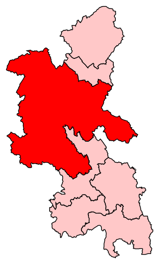
Buckinghamshire is a ceremonial county in South East England and one of the home counties. It is bordered by Northamptonshire to the north, Bedfordshire to the north-east, Hertfordshire to the east, Greater London to the south-east, Berkshire to the south, and Oxfordshire to the west. The largest settlement is the city of Milton Keynes, and the county town is Aylesbury.

<span class="mw-page-title-main">Buckingham</span> Town in Buckinghamshire, England

Buckingham is a market town in north Buckinghamshire, England, close to the borders of Northamptonshire and Oxfordshire, which had a population of 12,890 at the 2011 Census. The town lies approximately 12 miles (19 km) west of Central Milton Keynes, 19 miles (31 km) south-east of Banbury, and 24 miles (39 km) north-east of Oxford.

Dumnonia is the Latinised name for a Brythonic kingdom that existed in Sub-Roman Britain between the late 4th and late 8th centuries CE in the more westerly parts of present-day South West England. It was centred in the area of modern Devon, but also included modern Cornwall and part of Somerset, with its eastern boundary changing over time as the gradual westward expansion of the neighbouring Anglo-Saxon kingdom of Wessex encroached on its territory. The spelling Damnonia is sometimes encountered, but that spelling is also used for the land of the Damnonii, later part of the Kingdom of Strathclyde, in present-day southern Scotland. The form Domnonia also occurs. The name of the kingdom shares a linguistic relationship with the Breton region of Domnonée.

<span class="mw-page-title-main">Winslow, Buckinghamshire</span> Market town in Buckinghamshire, England

Winslow is a market town and civil parish in north Buckinghamshire, England, within the Buckinghamshire Council unitary authority area. It has a population of just over 4,400. It is located approximately 6 miles (9.7 km) south-east of Buckingham, and 7 miles (11 km) south-west of Bletchley.

<span class="mw-page-title-main">Brill, Buckinghamshire</span> Village in England

Brill is a village and civil parish in west Buckinghamshire, England, close to the border with Oxfordshire. It is about 4 miles (6 km) north-west of Long Crendon and 7 miles (11 km) south-east of Bicester. At the 2011 Census, the population of the civil parish was 1,141. Brill has a royal charter to hold a weekly market, but has not done so for many years.

<span class="mw-page-title-main">Bow Brickhill</span> Civil parish in the City of Milton Keynes, England

Bow Brickhill is a village and civil parish in the unitary authority area of the City of Milton Keynes, Buckinghamshire, England. It is bounded to the north, west and east by the Milton Keynes urban area, approximately 2 miles (3.2 km) east of Fenny Stratford, 1.5 miles (2.4 km) west of Woburn Sands and 4 miles (6.4 km) south-east of Central Milton Keynes.

Chearsley is a village and civil parish within the Buckinghamshire district in the ceremonial county of Buckinghamshire, England. It is situated about seven miles south west of Aylesbury, and about four miles north of Thame, in Oxfordshire.

Great Brickhill is a village and civil parish in the unitary authority area of Buckinghamshire, England. It is on the border with the City of Milton Keynes, located 6 miles (9.7 km) south-east of Central Milton Keynes, and 3 miles (4.8 km) in the same direction from Fenny Stratford.

<span class="mw-page-title-main">Wing, Buckinghamshire</span> Village in Buckinghamshire, England

Wing, known in antiquated times as Wyng, is a village and civil parish in east Buckinghamshire, England. The village is on the main A418 road between Aylesbury and Leighton Buzzard. It is about 8 miles (13 km) north-east of Aylesbury, 3 miles (5 km) west of Leighton Buzzard, and 12 miles (19 km) south of Milton Keynes.

<span class="mw-page-title-main">Buckingham (UK Parliament constituency)</span> Former Parliamentary constituency in the United Kingdom from 1542 to 2024

Buckingham was a constituency that was last represented in the House of Commons of the UK Parliament by Greg Smith, a Conservative.

<span class="mw-page-title-main">Parliamentary constituencies in Buckinghamshire</span>

The ceremonial county of Buckinghamshire, which includes the unitary authorities of Buckinghamshire and the City of Milton Keynes, is divided into 8 parliamentary constituencies – 1 borough constituency and 7 county constituencies. At the 2024 general election, the county returned 5 Labour MPs, 2 Conservatives and 1 Liberal Democrat.

<span class="mw-page-title-main">History of Milton Keynes</span> History of the city in England

This history of Milton Keynes details its development from the earliest human settlements, through the plans for a 'new city' for 250,000 people in northern Southeast England, its subsequent urban design and development, to the present day. Milton Keynes, founded in 1967, is the largest settlement and only city in Buckinghamshire. At the 2021 census, the population of its urban area was estimated to have exceeded 256,000.

<span class="mw-page-title-main">Railways in Buckinghamshire</span> Overview of the railway system in Buckinghamshire

The railway system of Buckinghamshire has a long and complex history dating back to the 1830s with the opening of sections of today's West Coast Main Line and Great Western Main Line. The development of Buckinghamshire's railway network was largely due to its position nationally as many long-distance routes chose to go through Buckinghamshire, especially between Britains two largest cities, London and Birmingham. The county had its own pulling power in addition, as produce such as the Aylesbury duck could then be easily transported to the capital.

<span class="mw-page-title-main">Transport in Buckinghamshire</span>

Transport in Buckinghamshire has been shaped by its position within the United Kingdom. Most routes between the UK's two largest cities, London and Birmingham, pass through this county. The county's growing industry first brought canals to the area, then railways and then motorways.

Eadgyth of Aylesbury also known as Eadridus was a Dark Ages Catholic saint from Anglo-Saxon England.

<span class="mw-page-title-main">Aylesbury Vale</span> Geographic region in Buckinghamshire, England

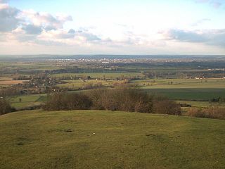
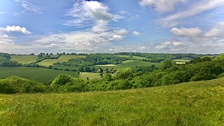
The Aylesbury Vale is a geographical region in Buckinghamshire, England, which is bounded by the City of Milton Keynes and West Northamptonshire to the north, Central Bedfordshire and the Borough of Dacorum (Hertfordshire) to the east, the Chiltern Hills to the south and South Oxfordshire to the west. It is named after Aylesbury, the county town of Buckinghamshire. Winslow and Buckingham are among the larger towns in the vale.

The Buckinghamshire Rugby Football Union is the governing body for the sport of rugby union in the county of Buckinghamshire in England. The union is the constituent body of the Rugby Football Union (RFU) for Buckinghamshire, and administers and organises rugby union clubs and competitions in the county. It also administers the Buckinghamshire county rugby representative teams. The union was founded at a meeting at High Wycombe on 16 July 1949 during a drinking session at one of the founders house.

<span class="mw-page-title-main">Buckinghamshire Council</span> Local authority in England

Buckinghamshire Council is the local authority for Buckinghamshire (district), a non-metropolitan county in England. It is a unitary authority, performing both county and district-level functions. It was created on 1 April 2020, replacing the previous Buckinghamshire County Council and the councils of the four abolished districts of Aylesbury Vale, Chiltern, South Bucks, and Wycombe. The territory of the Council is about four-fifths of Buckinghamshire and has about two-thirds of its population.

References

See also