Bromsgrove District

Last updated • 4 min readFrom Wikipedia, The Free Encyclopedia

52°20′06″N2°03′29″W / 52.335°N 2.058°W / 52.335; -2.058

Contents

Bromsgrove District
Georgian house on St John Street - geograph.org.uk - 5756531.jpg
Bromsgrove, the largest settlement and administrative centre of the district.
Bromsgrove UK locator map.svg
Bromsgrove shown within Worcestershire
Sovereign state United Kingdom
Constituent country England
Region West Midlands
Non-metropolitan county Worcestershire
Status Non-metropolitan district
Admin HQ Bromsgrove
Incorporated1 April 1974
Government
  TypeNon-metropolitan district council
  BodyBromsgrove District Council
  Leadership Leader & Cabinet (No overall control)
   MPs Bradley Thomas [1]
Area
  Total83.8 sq mi (217.0 km2)
  Rank139th (of 296)
Population
 (2022)
  Total100,076
  Rank245th (of 296)
  Density1,200/sq mi (460/km2)
Ethnicity (2021)
[2]
   Ethnic groups
List
Religion (2021)
[2]
   Religion
List
Time zone UTC0 (GMT)
  Summer (DST) UTC+1 (BST)
ONS code 47UB (ONS)
E07000234 (GSS)
OS grid reference SO9604870812

Bromsgrove is a local government district in north-east Worcestershire, England. It is named after its only town, Bromsgrove, where its council is based, but also includes several villages and surrounding rural areas. It borders the built-up area of Birmingham to the north. Other places in the district include Alvechurch, Aston Fields, Belbroughton, Catshill, Clent, Hagley, Rubery, Stoke Prior and Wythall. The population at the 2021 census was 99,475.

The neighbouring districts are Redditch, Wychavon, Wyre Forest, South Staffordshire, Dudley, Birmingham, Solihull and Stratford-on-Avon.

History

The town of Bromsgrove had been governed by improvement commissioners from 1846, [3] who were replaced by an elected local board in 1859, [4] which in turn was converted into an urban district council in 1894. [5]

The modern district was formed on 1 April 1974 under the Local Government Act 1972. The new district covered the area of two former districts, which were both abolished at the same time: [6]

The new district was named Bromsgrove after its largest settlement. [7]

Governance

Bromsgrove District Council
Bromsgrove District Council logo.png
Type
Type
Leadership
Sam Ammar,
Independent [8]
since 24 May 2023 [9] [10]
Karen May,
Conservative
since 22 May 2019
Chief Executive (interim)
Sue Hanley
since 2023 [11]
Structure
Seats31 councillors
Political groups
Administration (18)
  Conservative (11)
  Independent (7)
Other parties (13)
  Labour (7)
  Liberal Democrats (5)
  Independent (1)
Length of term
4 years
Elections
First past the post
Last election
4 May 2023
Next election
6 May 2027
Meeting place
Parkside Hall - geograph.org.uk - 5757439.jpg
Parkside, Market Street, Bromsgrove, B61 8DA
Website
www.bromsgrove.gov.uk

Bromsgrove District Council provides district-level services. County-level services are provided by Worcestershire County Council. [12] Much of the district is also covered by civil parishes, which form a third tier of local government for their areas. [13]

Bromsgrove forms part of the Greater Birmingham & Solihull Local Enterprise Partnership. Since 2008 the council has developed shared working arrangements with neighbouring Redditch Borough Council, with the two organisations sharing a chief executive, management team and other staff. [14]

Rubery, which straddles the border between Bromsgrove and Birmingham. A38 Rubery by-Pass from Whettybridge Road bridge - geograph.org.uk - 1109359.jpg
Rubery, which straddles the border between Bromsgrove and Birmingham.
Alvechurch, one of the many rural villages in the district The Square, Alvechurch.JPG
Alvechurch, one of the many rural villages in the district

Political control

The council has been under no overall control since the 2023 election, being run by an administration comprising the Conservatives and most of the independents, led by Conservative councillor Karen May. [15]

The first election to the council was held in 1973, initially operating as a shadow authority alongside the outgoing councils before coming into its powers on 1 April 1974. Since 1974 political control of the council has been as follows: [16] [17]

Party in controlYears
Conservative 1974–1995
Labour 1995–1999
Conservative 1999–2023
No overall control 2023present

Leadership

The leaders of the council since 1995 have been: [18]

CouncillorPartyFromTo
Nick Psirides Conservative May 1995
Trevor Porter [19] Labour May 19959 May 1999
Nick Psirides [20] Conservative May 1999May 2002
Dennis Norton [21] [22] Conservative May 200226 Sep 2005
Roger Hollingworth [23] Conservative 19 Oct 200514 May 2014
Margaret Sherrey [24] Conservative 14 May 201429 Jun 2016
Geoff Denaro Conservative 20 Jul 201622 May 2019
Karen May Conservative 22 May 2019

Composition

Following the 2023 election and a subsequent change of allegiance in June 2024, the composition of the council was: [25]

PartyCouncillors
Conservative 11
Independent 8
Labour 7
Liberal Democrats 5
Total31

Seven of the independent councillors sit together as the "2023 Independents" group, which forms the council's administration with the Conservatives. [26] The next election is due in 2027. [27]

Elections

Since the last boundary changes in 2015 the council has comprised 31 councillors representing 30 wards, with each ward electing one councillor except Belbroughton and Romsley ward which elects two. Elections are held every four years. [28]

Premises

The council is based at Parkside, at the corner of Market Street and Stourbridge Road. [29] The building was formerly the Parkside School, built in 1912. [30] The school moved to a new building in 2008. The old building was subsequently converted and extended to become the council's headquarters, as well as an area office for Worcestershire County Council and new library for the town, opening in 2015. [31]

When first created in 1974 the council had inherited offices at St John's Court (then known as the Council House) from Bromsgrove Urban District Council and at 94 Birmingham Road from Bromsgrove Rural District Council. [32] [33] [34] The council subsequently moved to a modern office building on Burcot Lane, also called the Council House, which was formally opened in 1986. [35] It remained there until the move to Parkside in 2015. The Burcot Lane building has since been demolished. [36]

Barnt Green, one of the many outlying villages in the district The Barnt Green Inn (1), 22 Kendal End Road, Barnt Green - geograph.org.uk - 2792350.jpg
Barnt Green, one of the many outlying villages in the district

Transport

Bromsgrove railway station is the local station for the district's centre, but there are several others within the district. Road travel, especially to Birmingham, is also important in the district.

Barnt Green railway station and Alvechurch railway station are on the line to Redditch.

Hagley railway station and Wythall railway station are also on lines leading into Birmingham, which pass through the edges of the district.

Hagley, one of the many villages in the district and also forms a small part of the Black Country near both Stourbridge and Halesowen. Sweetpool Lane, Hagley - geograph.org.uk - 3615201.jpg
Hagley, one of the many villages in the district and also forms a small part of the Black Country near both Stourbridge and Halesowen.

Bromsgrove is situated on Route 5 and 46 of the National Cycle Network. [37] This gives cyclists easy access to Droitwich, Redditch, Birmingham and beyond.

Parishes

Most of the district's area is covered by civil parishes, the exceptions being two separate parts of the pre-1974 Bromsgrove Urban District which have not since been added to parishes: one covering the main part of the Bromsgrove built-up area, and another around Rubery on the northern edge of the district adjoining Birmingham. [13] At the 2021 census, nearly half the district's population lived in the unparished areas. The most populous parishes are Wythall (which also contains the large village of Hollywood) and Hagley. [38] Each parish has a parish council. [39]

Population

The following table illustrates the change in the population of the area that makes up the modern district between 1801 and 2011.

YearPopulation [40]
180114,486
181116,330
182118,312
183120,720
184121,124
185122,960
186127,321
187131,682
188136,043
189141,992
190144,224
191146,574
192144,176
193141,903
194150,338
195160,470
196168,919
197178,555
198186,982
199192,251
200187,486
201193,600 [41]

See also

Related Research Articles

<span class="mw-page-title-main">Worcestershire</span> County of England

Worcestershire is a ceremonial county in the West Midlands of England. It is bordered by Shropshire, Staffordshire, and the West Midlands county to the north, Warwickshire to the east, Gloucestershire to the south, and Herefordshire to the west. The city of Worcester is the largest settlement and the county town.

<span class="mw-page-title-main">Bromsgrove</span> Human settlement in England

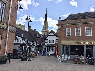
Bromsgrove is a town in Worcestershire, England, about 16 miles (26 km) north-east of Worcester and 13 miles (21 km) south-west of Birmingham city centre. It had a population of 34,755 in at the 2021 census. It gives its name to the wider Bromsgrove District, of which it is the largest town and administrative centre. In the Middle Ages, it was a small market town, primarily producing cloth through the early modern period. In the eighteenth and nineteenth centuries, it became a major centre for nail making.

<span class="mw-page-title-main">Redditch</span> Town and Borough in England

Redditch is a town and borough in Worcestershire, England. It is located south of Birmingham, east of Bromsgrove, northwest of Alcester and northeast of Worcester. The borough had a population of 87,037 in 2021. In the 19th century, it became a centre for the needle and fishing tackle industry.

<span class="mw-page-title-main">Wychavon</span> Non-metropolitan district in England

Wychavon is a local government district in Worcestershire, England. The largest towns are Evesham and Droitwich Spa; the council is based in the town of Pershore. The district also includes numerous villages and surrounding rural areas, and includes part of the Cotswolds, a designated Area of Outstanding Natural Beauty. The district's name references the Saxon Kingdom of Hwicce and the River Avon. The population in 2022 was 134,536.

<span class="mw-page-title-main">Wythall</span> Village and civil parish in Bromsgrove, England

Wythall is a village and civil parish in the Bromsgrove District, in the north-east corner of the county of Worcestershire, England. Wythall parish borders Solihull and Birmingham, and had a population of 12,269 in the UK census of 2021.

<span class="mw-page-title-main">Government of Birmingham</span>

Birmingham, a city and metropolitan borough in the West Midlands, England, is the second-largest city in the United Kingdom.

<span class="mw-page-title-main">Hollywood, Worcestershire</span> Village in Worcestershire, England

Hollywood is a large village predominantly located in the Bromsgrove district of Worcestershire, England, almost contiguous with and to the south of the city of Birmingham. Hollywood was formerly part of Kings Norton, but when Birmingham expanded in 1911, Hollywood remained in Worcestershire. The village now lies across the wards of Hollywood, most of Drakes Cross, the Trueman's Heath polling district area of Trueman's Heath parish ward and, following a 1966 border change, the southern portion of the Birmingham Highter's Heath ward, with all but the latter being located within the civil parish of Wythall. The southern part of the village is also known as Drakes Cross, whilst the eastern part is sometimes referred to as Trueman's Heath. Hollywood is situated in the extreme northeastern corner of Worcestershire, 8.5 miles / 13 km south of Birmingham city centre, 6 miles / 9.5 km west-southwest of Solihull and 8 miles / 12.5 km northeast of Redditch.

<span class="mw-page-title-main">Bromsgrove (UK Parliament constituency)</span> UK Parliament constituency in England since 1983

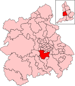
Bromsgrove is a constituency in Worcestershire, represented by Bradley Thomas of the Conservative Party.

<span class="mw-page-title-main">Belbroughton</span> Human settlement in England

Belbroughton is a village and civil parish in the Bromsgrove District of Worcestershire, England. According to the 2021 census it had a population of 2,685. It is about six miles north of Bromsgrove, six miles east of Kidderminster and four miles south of Stourbridge. The village of Clent is nearby. The village is served by bus service 318 (Bromsgrove-Stourbridge) operared by Kev's Cars and Coaches.

<span class="mw-page-title-main">Wyre Forest District</span> Non-metropolitan district in England

Wyre Forest is a local government district in Worcestershire, England. It is named after the ancient woodland of Wyre Forest. The largest town is Kidderminster, where the council is based. The district also includes the towns of Stourport-on-Severn and Bewdley, along with several villages and surrounding rural areas.

<span class="mw-page-title-main">Rubery</span> Human settlement in England

Rubery is the name of two adjacent settlements; one a village in the Bromsgrove District of Worcestershire, the other a suburb of Birmingham in the West Midlands, England. It is 4 miles (6.4 km) from Bromsgrove town centre, and 7 miles (11 km) from Birmingham city centre.

The Worcestershire County Cricket League (WCL) is an English club cricket league, and consists of club teams primarily from Worcestershire and Herefordshire, several other clubs from bordering counties Shropshire, Staffordshire and Warwickshire, and Wales.

<span class="mw-page-title-main">Worcestershire County Council</span> Local government body in England

Worcestershire County Council is the county council for the non-metropolitan county of Worcestershire in England. Its headquarters are at County Hall in Worcester, the county town. The council consists of 57 councillors and is currently controlled by the Conservative Party.

The 1999 Bromsgrove District Council election took place on 6 May 1999 to elect members of Bromsgrove district council in Worcestershire, England. The whole council was up for election and the Conservative Party gained overall control of the council from the Labour Party.

Walker's Heath is a small area spanning the southern border of the city of Birmingham, England and the Bromsgrove District of Worcestershire. It is located to the immediate south-east of the Birmingham suburb of Kings Norton.

<span class="mw-page-title-main">Evolution of Worcestershire county boundaries since 1844</span>

The administrative boundaries of Worcestershire, England have been fluid for over 150 years since the first major changes in 1844. There were many detached parts of Worcestershire in the surrounding counties, and conversely there were islands of other counties within Worcestershire. The 1844 Counties Act began the process of eliminating these, but the process was not completed until 1966, when Dudley was absorbed into Staffordshire.

<span class="mw-page-title-main">Redditch Borough Council</span>

Redditch Borough Council is the local authority for Redditch, a non-metropolitan district with borough status in Worcestershire, England.

References

  1. "GENERAL ELECTION RESULT - Conservatives hold Bromsgrove as Bradley Thomas wins seat". Bromsgrove Standard. Retrieved 5 July 2024.
  2. 1 2 UK Census (2021). "2021 Census Area Profile – Bromsgrove Local Authority (E07000234)". Nomis. Office for National Statistics . Retrieved 5 January 2024.
  3. A History of the County of Worcester: Volume 3. London: Victoria County History. 1913. pp. 19–33. Retrieved 10 February 2024.
  4. "No. 22324". The London Gazette . 11 November 1859. p. 4034.
  5. "Bromsgrove Urban District". A Vision of Britain through Time. GB Historical GIS / University of Portsmouth. Retrieved 10 February 2024.
  6. "The English Non-metropolitan Districts (Definition) Order 1972", legislation.gov.uk , The National Archives, SI 1972/2039, retrieved 31 May 2023
  7. "The English Non-metropolitan Districts (Names) Order 1973", legislation.gov.uk , The National Archives, SI 1973/551, retrieved 31 May 2023
  8. "Bromsgrove Council Chairman quits Labour Party to go independent". Bromsgrove Standard. Retrieved 10 June 2024.
  9. "Council minutes, 24 May 2023". Bromsgrove District Council. Retrieved 10 February 2024.
  10. "Bromsgrove's chairman keeps her chains for another year". Bromsgrove Standard. 20 May 2024. Retrieved 21 May 2024.
  11. "Council minutes, 19 July 2023". Bromsgrove District Council. Retrieved 10 February 2024.
  12. "Local Government Act 1972", legislation.gov.uk , The National Archives, 1972 c. 70, retrieved 31 May 2023
  13. 1 2 "Election Maps". Ordnance Survey. Retrieved 9 January 2023.
  14. Corporate Peer Challenge: Bromsgrove DC and Redditch BC (PDF). Local Government Association. 2018. p. 1. Retrieved 10 February 2024.
  15. "Bromsgrove District Council to consider committee system as it announces new leader and chairman". Bromsgrove Standard. 24 May 2023. Retrieved 2 February 2024.
  16. "Compositions calculator". The Elections Centre. 4 March 2016. Retrieved 20 August 2022.
  17. "Bromsgrove council". BBC News Online . Retrieved 9 June 2009.
  18. "Council minutes". Bromsgrove District Council. Retrieved 20 September 2022.
  19. "Leader rejoices at 'dream' win". Birmingham Mail. 5 May 1995. p. 15. Retrieved 20 September 2022.
  20. "Tories set to ditch costly leisure centre plan". Birmingham Post. 12 May 1999. p. 4. Retrieved 20 September 2022.
  21. "Calls for council leader to resign". Worcester News. 10 November 2004. Retrieved 20 September 2022.
  22. "Who will be new leader?". Worcester News. 5 October 2005. Retrieved 20 September 2022.
  23. Harris, Tristan (2 February 2016). "Tributes paid to former Bromsgrove Council leader who died suddenly at 71". Bromsgrove Standard. Retrieved 20 September 2022.
  24. Collis, Emily (5 July 2016). "Margaret Sherrey to stand down as Bromsgrove District Council leader after health scare". Bromsgrove Advertiser. Retrieved 20 September 2022.
  25. "Local elections 2023: live council results for England". The Guardian.
  26. "Your Councillors by Political Grouping". Bromsgrove District Council. Retrieved 10 February 2024.
  27. "Bromsgrove". Local Councils. Thorncliffe. Retrieved 24 July 2024.
  28. "The Bromsgrove (Electoral Changes) Order 2014", legislation.gov.uk , The National Archives, SI 2014/18, retrieved 10 February 2024
  29. "Contact: Main council details". Bromsgrove District Council. Retrieved 10 February 2024.
  30. Historic England. "Parkside School (Grade II) (1392999)". National Heritage List for England . Retrieved 10 February 2024.
  31. Greenway, Sam (9 June 2015). "Multi-million pound project to create council hub to be completed in August". Bromsgrove Advertiser. Retrieved 10 February 2024.
  32. The Municipal Year Book. London: Municipal Journal. 1976. p. 670.
  33. "No. 45840". The London Gazette . 1 December 1972. p. 14354.
  34. Historic England. "St John's Court (Grade II) (1100362)". National Heritage List for England .
  35. "Smiling princess charms the crowds". Sandwell Evening Mail. 5 April 1986. p. 3. Retrieved 10 February 2024.
  36. "Demolition to begin on former Bromsgrove Council House next month to make way for 61 homes". Bromsgrove Standard. 30 October 2020. Retrieved 10 February 2024.
  37. "Sustrans". Sustrans.org.uk. Retrieved 7 October 2019.
  38. "Bromsgrove District with parishes". City Population. Retrieved 10 February 2024.
  39. "Parish council contact details". Bromsgrove District Council. Retrieved 10 February 2024.
  40. "Vision of Britain". GIS Project. Retrieved 14 January 2006.
  41. Office for National Statistics, first release of data from 2011 census.