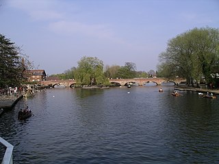
The River Avon in central England flows generally southwestwards and is a major left-bank and easternmost tributary of the River Severn. It is also known as the Warwickshire Avon or Shakespeare's Avon, to distinguish it from several other rivers of the same name in the United Kingdom.
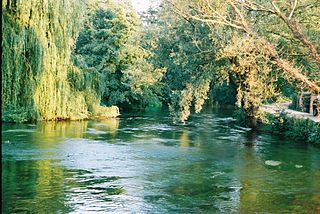
The River Test is a chalk stream in Hampshire in the south of England. It rises at Ashe near Basingstoke and flows southwards for 40 miles (64 km) to Southampton Water. Settlements on the Test include the towns of Stockbridge and Romsey. The river's valley gives its name to the local government district of Test Valley. Below the village of Longparish, the river is broadly followed by the Test Way, a long-distance footpath.

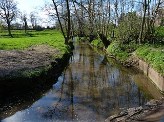
The River Leam is a river in England which rises at Hellidon Hill in Northamptonshire then flows through Warwickshire, including the town of Leamington Spa, named after it. It then flows into the River Avon near Warwick, which flows into the River Severn.

The River Churn is a tributary of the River Thames in central England. It rises at Seven Springs in Gloucestershire and flows south for approximately 37.3 km (23.2 mi) to meet the Thames at Cricklade in Wiltshire. Its length from its source to the confluence with the Thames is greater than that of the Thames from Thames Head, but the Churn is regarded as a tributary, rather than the main river.

The River Lugg rises near Llangynllo in Radnorshire, Wales. It flows through the border town of Presteigne and then through Herefordshire, England, where it meets its main tributary, the River Arrow, to the south of Leominster. It flows into the River Wye downstream of Hereford at Mordiford, around 63 miles (101 km) from its source. Its name comes from a Welsh root, and means "bright stream".

The River Clun runs mostly through Shropshire, England and joins the River Teme at Leintwardine, Herefordshire. The Clun Valley is part of the Shropshire Hills AONB.

The River Itchen flows through east Warwickshire in England. It is a small river, about 18 miles (29 km) long, and its general course is from south to north.

The River Allen is a river in the county of Dorset in South West England. It flows for 14 miles (23 km) to its confluence with the River Stour immediately south of Wimborne Minster, between that town and the village of Oakley. It has two main tributaries, the Gussage Stream and the Crichel Stream.
The River Coln is a river in Gloucestershire, England. It rises to the north of Brockhampton, a village to the east of Cheltenham, and flows in a south/south-easterly direction through the Cotswold Hills via Andoversford, Withington, Fossebridge, Bibury, Coln St Aldwyns, Quenington and Fairford. It joins the River Thames to the south-west of Lechlade, near to the confluence with the Thames and Severn Canal.

The River Perry is a river in Shropshire, England. It rises near Oswestry and flows south to meet the River Severn above Shrewsbury. Along its 24 miles (39 km) length, its level drops by some 320 feet (95 m). The channel has been heavily engineered, both to enable water mills to be powered by it, and to improve the drainage of the surrounding land. There were at least seven corn mills in the 1880s, and the last one remained operational until 1966. The middle section of the river crosses Baggy Moor, where major improvements were made in 1777 to drain the moor. The scheme was one of the largest to enclose and improve land in North Shropshire, and the quality of the reclaimed land justified the high cost. A section of the river bed was lowered in the 1980s, to continue the process.

The River Vyrnwy flows through northern Powys, Wales, and Shropshire, England. The name derives from Severn, the river of which it is a tributary.

The River Chelt is a tributary of England's largest river, the Severn. The Chelt flows through the western edge of the Cotswolds and the town of Cheltenham, from which it derives its name, before its confluence with the River Severn at Wainlodes Hill.

Quinny Brook is a tributary stream of the River Onny which flows through the Shropshire Hills Area of Outstanding Natural Beauty in England.

The River Wey is a main tributary of the River Thames in south east England. Its two branches, one of which rises near Alton in Hampshire and the other in West Sussex to the south of Haslemere, join at Tilford in Surrey. Once combined, the flow is eastwards then northwards via Godalming and Guildford to meet the Thames at Weybridge. Downstream the river forms the backdrop to Newark Priory and Brooklands. The Wey and Godalming Navigations were built in the 17th and 18th centuries, to create a navigable route from Godalming to the Thames.

The River Leadon is a river in Herefordshire and Gloucestershire, England, a tributary of the River Severn. It rises just south of the village of Acton Beauchamp, and flows south past Bosbury to the town of Ledbury, which takes its name from the river. It then flows south and east past Dymock, Upleadon and Highleadon to join the Severn at Over, just west of Gloucester. The river is approximately 32 miles (51 km) long.

The River Worfe is a river in Shropshire, England. The name Worfe is said to derive from the Old English meaning to wander which the river is notable for in its middle section. Mapping indicates that the river begins at Cosford Bridge where the Cosford Brook and Albrighton Brook meet.

The Afon Dulas is a river in Powys, Wales. It is a headwater tributary of the River Severn, which it joins at Llanidloes opposite the confluence with the Afon Clywedog. Its principal tributary is the Afon Brochan. The total length of the Dulas and Brochan is 19.6 km. Other tributaries include Nant Cydros, the Rhydyclwydau Brook and Nant Gynwydd.

The Bow Brook is a substantial brook that flows for 28.8 miles (46.3 km) through Worcestershire, England. It is a lower tributary of the River Avon which it joins near Defford downstream of Eckington Bridge. Its principal tributaries include the Stoulton, Dean, and Seeley brooks.
The Badsey Brook, also known as the Broadway Brook, is a small brook that flows through Worcestershire, England. It is a lower tributary of the River Avon, which it joins near Offenham upstream of Evesham. Its principal tributary is the Bretforton Brook.
The Finham Brook is a lower tributary of the River Sowe, it flows through Kenilworth and Warwickshire, England, to join the Sowe near Finham. Its principal tributaries include the Canley Brook, which drains the Tile Hill and Canley areas of Coventry, and the Inchford Brook which rises near Beausale, and then flows in an arc through the parish of Beausale, Haseley, Honiley and Wroxall. The length of the Finham and Inchford brooks is 15 miles (24 km), which have a total catchment area of 71 square kilometres (27 sq mi).

