A Saxon charter of the year 817 records that Coenwulf, King of Mercia, granted the manor of Salwarpe to Denebeorht, Bishop of Worcester, and his Priory.[2] By the 11th century, the grant had been alienated, and a nobleman named Godwine had possession of the principal manor of Salwarpe, while his brother Leofric, Earl of Mercia, was a lesser landowner there. As Godwine was dying about 1052, Saint Wulfstan, who was Dean of Worcester, persuaded him to give his manor of Salwarpe back to Worcester Priory, but Godwine's son Ethelwine (named in the Domesday Book as being in possession in the time of King Edward) repudiated his father's Will and kept it, denying the bequest to the Priory.[2] Salwarpe was in the ancient hundred of Clent.[3]
The ancient parish of Salwarpe contains several hamlets. The early nineteenth-century enclosure map shows Boycott, Chauson, Copcott, High Park, Hill End, Ladywood, Middleton, Newland, and Oakley, and most of these names were also recorded in the 17th century.[2][8]
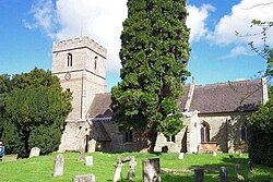
The Church of Englandparish church, dedicated to St Michael and All Angels, is unusually large for a village now so small, but it reflects greater importance in past centuries. Parts of the church are Norman.[9]
In 1868, the National Gazetteer of Great Britain and Ireland said
SALWARPE, a parish in the borough of Droitwich, upper division of Halfshire hundred, county Worcester, 5½ miles N. of Worcester, its post town, and 2 S.W. of Droitwich. The village, which is of small extent, is situated on the Droitwich canal and the river Salwarpe; the latter takes its rise under Lickey hills, thence flows 14 miles S.W. past Bromsgrove, Stoke-Prior, and Droitwich, to the Severn, at Hawford Bridge. Salwarpe, in Leland's time, was called Salop. The celebrated Earl of Warwick, Richard Beauchamp, was born here in 1351 [sic].[10]
Salwarpe has a post box dating from the reign of Queen Victoria. The wall-mounted box just beyond the churchyard was made by the Birmingham founders, Smith & Hawkes, based in Broad Street. It was made sometime between the mid-1850s and mid 1870s when Smith & Hawkes was active in the manufacture of post-boxes. The current box is the original, though it was reset in the early 2000s when it was in danger of being replaced by the Post Office.
Sir John Talbot (1630–1714), soldier and politician, had his country seat at Salwarpe Court.
William Hallifax (1655–1722), translator of Euclid, chaplain to the Levant Company, early explorer of Palmyra, chaplain to the Speaker of the House of Commons, rector of Oldswinford (1699–1722) and Salwarpe (1713–1722).
Jennifer Harris, (1989–present), Member of the Emmanuel College team which won University Challenge 2010
1 2 Richard Gough, Description of the Beauchamp chapel, adjoining to the church of St. Mary, at Warwick. And the monuments of the earls of Warwick, in the said church and elsewhere (Warwick Town, St Mary, 1803), p. 17
This page is based on this Wikipedia article Text is available under the CC BY-SA 4.0 license; additional terms may apply. Images, videos and audio are available under their respective licenses.