Bengeworth | |
---|---|
Location within Worcestershire | |
OS grid reference | SP045430 |
• London | 88 miles (142 km) |
Civil parish | |
District | |
Shire county | |
Region | |
Country | England |
Sovereign state | United Kingdom |
Post town | EVESHAM |
Postcode district | WR11 |
Dialling code | 01386 |
Police | West Mercia |
Fire | Hereford and Worcester |
Ambulance | West Midlands |
Bengeworth is a locality in the civil parish of Evesham, in the Wychavon district, in the county of Worcestershire, England. In 1887 it had a population of 1,311. [1] Today it has a school [2] and an Anglican church. [3]
Bengeworth was an early hamlet in one of the three Anglo-Saxon hundreds (Cuthburgelow, Winburgetreow and Wulfereslaw) that were combined to form the triple hundred of Oswaldslow, located across the River Avon from the town of Evesham. [4] The etymology indicates that Bengeworth may have been a named location in Anglo-Saxon England as early as the Kingdom of the Hwicce, which was subsumed into the Kingdom of Mercia. From 927, the Kingdom of England ruled the land.
Prior to the Conquest of 1066, Bengeworth was in the triple hundred of Oswaldslow, owned by Evesham Abbey and the Bishop of Worcester. [5] Due to prompt intercession by the abbot, Evesham Abbey was not reduced by William the Conqueror. By 1086, Evesham Abbey owned the entirety of Bengeworth (scribed in Domesday once as Beningeorde (cf. Old English: ben (petition, prayer) + ing (pasture) [6] (perhaps heard by the Domesday scribe as Old French: bening = benign, good – from Latin benignus); Old English: eorðe = earth, ground) and once as Bennieworte (cf. Anglo-Saxon: bene = prayer; worð = land, farm, street, public way)), [6] a larger than average hamlet whose inhabitants were a mixture of free, serf and slave. [5] [7] Beningwyrde is another early spelling used in the Worcester Survey, a land survey undertaken in Worcestershire sometime between 1108 and 1118.
Wulfstan II of Worcester, the last surviving pre-Conquest bishop, held the office in 1086 according to the Domesday Book. When Walter de Beauchamp built a castle in Bengeworth on the north end of the bridge to Evesham, conflict with the Abbot of Evesham escalated. Following his attack upon Evesham, Beauchamp was excommunicated and his Bengeworth castle destroyed. [8] His descendant William Beauchamp of Elmley was said to have withdrawn his part of Bengeworth from the bishop's hundred about the middle of the 13th century, and in 1280 all of Bengeworth was in Blackenhurst hundred. [9]
The Bishops of Worcester continued to exert sac and soc over Bengeworth and other communities in Oswaldslow Hundred until the Dissolution of the Monasteries in the 16th century, six to eight centuries of Catholic ecclesiastical rule. The English Reformation led to the development of the Anglican church in Bengeworth.
The lordship of Bengeworth was retained by a series of families from 1535 onward through the Victorian era. [10] Rebecca Rushout (née Bowles), Lady Northwick, held the manor in 1810. [10]
The 1605 charter of the Borough of Evesham added the Parish of Bengeworth within its boundary, superseding the initial 1604 borough charter which had encompassed the parishes of All Saints and St. Lawrence. Over the next two centuries, the population of Bengeworth expanded to the north and east, while Evesham expanded to the north and west. [11]
The inhabitants of Bengeworth and nearby Evesham were deeply involved in the English Civil War in the early 17th century. Five Parliamentarian soldiers who participated in the horror of the war became convinced of the pacifist theology of the Society of Friends, and met for religious meetings in 1655 at the home of Thomas Cartwright in Bengeworth. [12] Their beliefs greatly disturbed the mainstream religious and secular authorities, which caused their persecution. [12]
The medieval Anglican church was demolished in 1870. It was replaced by Bengeworth St. Peter, a large church designed in the Gothic Decorated style by Thomas Denville Barry and his son Charles Garret Barry, of the firm T. D. Barry and Sons of Liverpool, and built between 1870/72. [13] [14] The architect John Henry Price first articled at their firm 1884–1888. William Blews & Sons of New Bartholomew Street, Birmingham, cast the church bells. [15]
In 1921 the civil parish had a population of 3268. [16] On 1 April 1924 the parish was abolished and merged with Evesham. [17]
The Bengeworth Post Office was forced to close, which led to protests in 2008. [18]
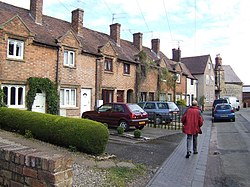
In the late 18th century, free schooling in Bengeworth was charitably endowed through donations and bequests of South Sea Stock and South Sea Annuities from investors who had profited from the restructured South Sea Company. John Deacle's Charity funded the purchase of land and construction of a school in Bengeworth. [19]
The Bengeworth CE Academy had to suspend classroom instruction and begin a home learning program for its students on 20 March 2020 to aid the nationwide effort to decrease the rate of transmission of COVID-19. [20]
It was served by the nearby Bengeworth railway station on the Gloucester Loop Line on the Midland Railway between Ashchurch and Evesham. Bengeworth railway station was not in Bengeworth, but rather was the station in the centre in the nearby village of Hampton. The railway station was called 'Bengeworth' as that was considered a distinctive name, while 'Hampton' is a common England village name.
The station opened 1 October 1864. [21] It closed in 1953, but trains continued to use the line until closure in 1963.
Worcestershire is a ceremonial county in the West Midlands of England. It is bordered by Shropshire, Staffordshire, and the West Midlands county to the north, Warwickshire to the east, Gloucestershire to the south, and Herefordshire to the west. The city of Worcester is the largest settlement and the county town.
Evesham is a market town and parish in the Wychavon district of Worcestershire, in the West Midlands region of England. It is located roughly equidistant between Worcester, Cheltenham and Stratford-upon-Avon. It lies within the Vale of Evesham, an area comprising the flood plain of the River Avon, which has been renowned for market gardening. The town centre, situated within a meander of the river, is subjected regularly to flooding. The 2007 floods were the most severe in recorded history.
Wulfstan, was an English Benedictine monk who served as Bishop of Worcester from 1062 to 1095. He was the last surviving pre-Conquest bishop. Wulfstan is a saint in the Western Christian churches.
The area now known as Worcestershire has had human presence for over half a million years. Interrupted by two ice ages, Worcestershire has had continuous settlement since roughly 10,000 years ago. In the Iron Age, the area was dominated by a series of hill forts, and the beginnings of industrial activity including pottery and salt mining can be found. It seems to have been relatively unimportant during the Roman era, with the exception of the salt workings.
Kempsey is a village and civil parish in the Malvern Hills District in the county of Worcestershire, England. It is bounded by the River Severn on the west, and the A38 main road runs through it and is about 3 miles (5 km) south of Worcester. The village has a long history. Its name is derived from the Saxon "Kemys' Eye", or the island of Kemys. Kemys was a Saxon chief, whose island lay between marshes and the River Severn. One of the roads in Kempsey, Lyf's Lane, is named after another Saxon chief. The village was recorded in the 11th century Domesday Book as having a value of £7.
White Ladies Aston is a village in the Wychavon local government district of Worcestershire, England, United Kingdom, and also lends its name to the civil parish in which the village is located. The village is located to the east of the A44 which started as a Saltway linking Droitwich to Oxford. To the south is Pershore and five miles west is Worcester. The parish is bound to the east by the Bow Brook. The parish, according to the 2011 census, has 87 households with 220 residents.
Little Witley is a village and civil parish in the Malvern Hills District in the county of Worcestershire, England.
Ombersley is a village and civil parish in Wychavon district, in the county of Worcestershire, England. The parish includes the hamlet of Holt Fleet, where Telford's 1828 Holt Fleet Bridge crosses the River Severn. The 2011 census recorded a population of 2,360 for the parish.
Wixford is a hamlet and civil parish in the Stratford-on-Avon District of Warwickshire, England, situated 1.5 miles (2.4 km) south of Alcester. The population at the 2011 census was 155. The area is largely agricultural with no large employers in the area, most residents commuting to larger towns nearby.
John Watson (1520–1584) was Bishop of Winchester in the 1580s.
Harvington is a village near Evesham in Worcestershire, England. Bounded by the River Avon to the south and the Lench Hills to the north, three miles northeast of Evesham and now on the Worcestershire/Warwickshire border. The village today is an amalgamation of two smaller villages, Harvington and Harvington Cross, and has a population of around 1,750.
Stoke Prior is a village in the civil parish of Stoke in the Bromsgrove district of Worcestershire. The parish includes the settlement of Stoke Wharf and hamlet of Woodgate, along with neighbouring Stoke Heath.
Peopleton is a village and civil parish in the Wychavon district of Worcestershire, England. In 2001 the parish had a population of 640, with 245 households.
Stone is a village and civil parish in the Wyre Forest District of Worcestershire, England. Of Anglo-Saxon origin, it lies two miles south-east of Kidderminster on the A448 road to Bromsgrove.
Croome D'Abitot is a village and civil parish, which shares a joint parish council with Severn Stoke, in the Malvern Hills District in the county of Worcestershire, England. The parish church of St Mary Magdalene is situated in the grounds of Croome Court.
Cyneweard of Laughern or simply Cyneweard was a mid-11th century Anglo-Saxon thegn and sheriff in Worcestershire, England. Probably the son of Æthelric Kiu and grand-nephew of Wulfstan Lupus, Archbishop of York (1003–1023), he was one of the leading nobles of the county at the Norman Conquest of England. On the death of Edward the Confessor he held lands in Gloucestershire and Warwickshire as well as Worcestershire.
The Oswaldslow was a hundred in the English county of Worcestershire, which was named in a supposed charter of 964 by King Edgar the Peaceful. It was actually a triple hundred, composed of three smaller hundreds. It was generally felt to be named after Bishop Oswald of Worcester, and created by the merging of Cuthburgelow, Winburgetreow and Wulfereslaw Hundreds.
North Piddle is a small civil parish in the Wychavon district of Worcestershire, England. It is located within a loop of Piddle Brook.
Salwarpe is a small village and civil parish in the Wychavon district of Worcestershire, England, less than two miles south west of Droitwich, but in open country. The name is also spelled Salwarp, and in the time of John Leland was recorded as Salop. Since 2003, Salwarpe has shared a parish council with Hindlip and Martin Hussingtree.
Walter, Abbot of Evesham or Walter de Cerisy, Gauthier de Cerisy was an 11th-century abbot and church leader in England under the Norman conquest. He is known from the Domesday Book and several legal documents.