Bredon

Last updated

Bredon
Bredon-milestone.jpeg
The milestone obelisk in Bredon, with the parish church of St Giles in the background.
Worcestershire UK location map.svg
Red pog.svg
Bredon
Location within Worcestershire
Population2,705 
OS grid reference SO925369
  London 93 miles (150 km)
Civil parish
  • Bredon
District
Shire county
Region
Country England
Sovereign state United Kingdom
Post town Tewkesbury
Postcode district GL20
Dialling code 01684
Police West Mercia
Fire Hereford and Worcester
Ambulance West Midlands
UK Parliament
Website http://www.bredonpc.org.uk/
List of places
UK
England
Worcestershire
52°01′48″N2°07′01″W / 52.030°N 2.117°W / 52.030; -2.117

Bredon is a village and civil parish in Wychavon district at the southern edge of Worcestershire in England. It lies on the banks of the River Avon on the lower slopes of Bredon Hill.

Contents

Location and geography

Bredon is located 3 miles (4.8 km) north of the Gloucestershire town of Tewkesbury on the B4080 road. The River Avon forms the western boundary of the parish, and two of its tributaries, the Carrant Brook and Squitter Brook form the southern boundary.

The parish extends from the Avon valley floor at an elevation of 32 feet (9.8 m) in the south-west to the upper slopes of Bredon Hill at an elevation of 820 feet (250 m) in the north-east. The northern third of the parish falls within the Cotswolds AONB. At its greatest extent, the parish measures approximately 4.8 miles (7.7 km) long by 2.2 miles (3.5 km) wide and covers around 4,119 acres (16.67 km2).

Population

Bredon parish includes the hamlets of Bredon's Hardwick, Kinsham and Westmancote. At the 2021 census the parish had a population of 2,705. [1]

History

Bredon's history of farming and settlement goes back at least four thousand years. Archaeological remains establish that parts of the parish were settled early in the Bronze Age (2500–800 BC). [2] There are numerous Iron Age (800 BC–100 AD) remains, some of which would have related to Kemerton Camp, a large univallate hillfort at the summit of Bredon Hill. The parish is also rich in remains from the Britto-Roman Period (43–410 AD), revealing a continuing history of settlement and farming.

Modern Bredon has its roots in the Anglo-Saxon period (c.500–1066), when in c.716 Æthelbald, King of Mercia, gave land to his kinsman Eanwulf the grandfather of Offa to found a monastery. For some time, the manor of Bredon continued under an abbot of its own, but by 844 it had become the property of the Bishop of Worcester. It remained part of the Worcester monastic estate until the Reformation. Bredon's name evolved during the Saxon period, deriving from bree (Celtic for hill) and don (Old English for hill).

From the Norman Conquest (1066) to the end of the Late Medieval Period (1500), the parish was governed under the feudal system. The manor was held by the Bishop of Worcester, who maintained a summer residence, park and fisheries on the site of the first monastery, and the medieval village developed around these church buildings. Following the Reformation in the 16th century, the manor passed to the Crown.

In 1718, wealthy resident William Hancock founded Bredon Hancock's Endowed Church of England First School. Bredon's Act of Inclosure was passed in 1811, and among those gaining large consolidated holdings were the lord of the manor, Rev. Richard Darke, and the rector, Rev. John Keysall. [3]

The Birmingham and Gloucester Railway, one of the world's oldest main line railways, was constructed during the 1830s and 1840s through the village, with Bredon railway station opening in 1841. This remained in operation until 1965, when it was closed under the Beeching Axe. The station is currently closed on the Cross Country Route.

In February 1971, a new section of the M5 motorway was opened, cutting through the parish to the west of the village.[ citation needed ]

Buildings

There are 43 listed buildings in the village, including St Giles's Church and Bredon Barn (both Grade I), and the Old Rectory (Grade II*); the remainder are Grade II. A further 41 buildings were formerly listed prior to the abolition of the Grade III category in 1970. As is the case in most Cotswold villages, a variety of architectural styles and materials are in evidence, but almost all historic buildings are at least partly built from Cotswold limestone, quarried on Bredon Hill. Timber-frame construction was used as a secondary material up until the mid-17th century (often not painted black and white until the 20th century).

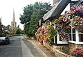
The earliest surviving building in the village, the parish church of St Giles, is one of England's most admired churches. [4] It is built largely in the Norman, Early English and Decorated styles. A substantial part of the nave, the north porch and the western tower arch date from the 12th century, with significant additions in the 13th and 14th centuries – the most visible being a tall, octagonal spire, dating from 1300 to 1350, made famous by the poet, John Masefield. A number of 14th century heraldic tiles are set in the sanctuary steps, showing the arms of England, France, Beauchamp of Powick, Beauchamp of Warwick, Mortimer, Berkeley and others. The church contains many interesting monuments, including several to members of the interrelated Reed, Copley and Parsons families.

To the west of the church is Bredon Barn, [5] a late 14th century threshing barn (often incorrectly referred to as a tithe barn) measuring approximately 40 metres by 12 metres. It has an enormous steep pitched roof covered in Cotswold limestone tiles. Walls are of limestone rubble masonry, divided into nine bays by oak posts on stone plinths forming aisles and carrying the open timber roof. The barn was badly damaged by fire in 1980. Now restored, it is in the care of the National Trust.

Natural history

Bredon and its surroundings are exceptionally rich in wildlife, boasting sites of international importance for their rare fauna. [6] The parish contains parts of the Bredon Hill Special Area of Conservation; parts of three Sites of Special Scientific Interest; and parts of twelve Local Wildlife Sites (the best sites in Worcestershire not covered by national designations).

Bredon Hill has been recognised as the third most important site in the UK for dead-wood beetles and other invertebrates, [7] a large proportion of which are in Bredon. The north of the parish is the richest area in Worcestershire for rare arable plants. [8] Kemerton Lake Nature Reserve (half in the parish), managed by the Kemerton Conservation Trust, is the West Midlands Region's most important site for dragonflies, with 22 species recorded. [9] It is also Worcestershire's most important site for jack snipe, and more than 170 other bird species have been recorded here. Purple milk-vetch, violet click beetle, barbastelle bat, lesser horseshoe bat, otter, polecat and great-crested newt are some of the other interesting species found in and around the village.

See also

Related Research Articles

<span class="mw-page-title-main">Broadway, Worcestershire</span> Human settlement in England

Broadway is a large village and civil parish in the Cotswolds, England, with a population of 2,540 at the 2011 census. It is in the far southeast of Worcestershire, close to the Gloucestershire border, midway between Evesham and Moreton-in-Marsh. It is sometimes referred to as the "Jewel of the Cotswolds".

<span class="mw-page-title-main">Bredon Hill</span> Natural feature in Worcestershire, England

Bredon Hill is a hill in Worcestershire, England, south-west of Evesham in the Vale of Evesham. The summit of the hill is in the parish of Kemerton, and it extends over parts of eight other parishes. The hill is geologically part of the Cotswolds and lies within the Cotswolds Area of Outstanding Natural Beauty. However, it now stands isolated in the Vale of Evesham due to natural causes.

<span class="mw-page-title-main">Ashton under Hill</span> Human settlement in England

Ashton under Hill is a village and civil parish in the Wychavon district of Worcestershire in England. It is situated at the foot of Bredon Hill. According to the 2001 census the parish had a population of 743, about six miles south-west of Evesham. A five house hamlet named Paris is located above the village with panoramic views over the surrounding hills.

<span class="mw-page-title-main">Cropthorne</span> Human settlement in England

Cropthorne is a village and civil parish in Worcestershire, England within the Vale of Evesham, and on the North-west edge of the Cotswolds. It is approximately 13 miles (21 km) southeast of Worcester, 19 miles (31 km) north of Cheltenham, and 18 miles (29 km) southwest of Stratford-upon-Avon. Cropthorne has a population of 603, in 237 households. Located on a small ridge overlooking the River Avon, its ancient orchards sweep down to the river and offer clear, unbroken views across the vale to the Malvern Hills in the distance. It is featured in the Domesday Book, and St Michael's Church dates back to the 12th century. The church is a Grade I listed building. The village has many unique examples of timber-framed thatched cottages from the 16th and 17th centuries, and about half the village is designated as a Conservation area. The village has a Site of Special Scientific Interest, Cropthorne New Inn Section.

<span class="mw-page-title-main">Ombersley</span> Village in Worcestershire, England

Ombersley is a village and civil parish in Wychavon district, in the county of Worcestershire, England. The parish includes the hamlet of Holt Fleet, where Telford's 1828 Holt Fleet Bridge crosses the River Severn. The 2011 census recorded a population of 2,360 for the parish.

<span class="mw-page-title-main">Stanton, Gloucestershire</span> Human settlement in England

Stanton is a village and civil parish in Tewkesbury Borough, Gloucestershire, England. The village is a spring line settlement at the foot of the Cotswold escarpment, about 2+12 miles (4 km) southwest of Broadway in neighbouring Worcestershire. Broadway is Stanton's postal town. The 2011 Census recorded the parish's population as 198.

<span class="mw-page-title-main">Overbury</span> Human settlement in England

Overbury is a village and civil parish in Worcestershire, England, midway between Evesham and Tewkesbury south of Bredon Hill.

<span class="mw-page-title-main">Honeybourne</span> Village and civil parish in Worcestershire, England

Honeybourne is a village and civil parish about 5 miles (8 km) east of Evesham in Worcestershire, England. Much of the parish is farmland. RAF Honeybourne just south of the village was operational from 1940 until 1947.

<span class="mw-page-title-main">Kemerton</span> Human settlement in England

Kemerton is a village and civil parish in Worcestershire in England. It lies at the extreme south of the county in the local government district of Wychavon. Until boundary changes in 1931, it formed part of neighbouring Gloucestershire, and it remains in the Diocese of Gloucester. The northern half of the parish lies within the Cotswolds Area of Outstanding Natural Beauty.

<span class="mw-page-title-main">Kemerton Court</span> Country house in Gloucestershire, United Kingdom

Kemerton Court is the principal manor house of the village of Kemerton, near Tewkesbury in Gloucestershire.

<span class="mw-page-title-main">Bretforton</span> Human settlement in England

Bretforton is a rural village in Worcestershire, England, 4.4 miles (7.1 km) east of Evesham, in the Vale of Evesham. It is the largest farming village near Evesham. At the 2001 census, Bretforton had a population of 1,023 in 428 households. The area of the parish is 2.83 square miles.

<span class="mw-page-title-main">Childswickham</span> Village in Worcestershire, England

Childswickham is a village in Worcestershire, England, situated within the flat open landscape of the Vale of Evesham, between the Bredon and Cotswold Hills, two miles from Broadway. It is within the boundaries of the historic county of Gloucestershire. It is an area predominantly of market gardening, arable and pasture land, with surrounding fields defined by hedgerows.

<span class="mw-page-title-main">Great Comberton</span> Human settlement in England

Great Comberton is a village in Worcestershire, England, United Kingdom.

<span class="mw-page-title-main">Hinton on the Green</span> Human settlement in England

Hinton on the Green is a village and civil parish in the Wychavon district of Worcestershire in England. It is situated at the foot of Bredon Hill, about two miles south of Evesham.

<span class="mw-page-title-main">Strensham</span> Human settlement in England

Strensham is a village in the Wychavon district of Worcestershire. In the 2001 census, the civil parish of Strensham had a population of 314 across 127 households. Since 1991, the population has risen 28.7% from 244 residents.

<span class="mw-page-title-main">North and Middle Littleton</span> Human settlement in England

North and Middle Littleton is a civil parish located in the Wychavon district of Worcestershire, England. The parish comprises the villages of North Littleton and Middle Littleton, and is located near the larger settlement of South Littleton. It is bounded by the River Avon to the west, and Buckle Street to the east. At the 2001 census it had a population of 906.

<span class="mw-page-title-main">North Piddle</span> Human settlement in England

North Piddle is a small civil parish in the Wychavon district of Worcestershire, England. It is located within a loop of Piddle Brook.

<span class="mw-page-title-main">Bredon Barn</span> 14th-century barn in Bredon, Worcestershire, England

Bredon Barn is a large 14th-century threshing barn located at Bredon, Worcestershire, England, standing close to the River Avon.

<span class="mw-page-title-main">Tidmington</span> Human settlement in England

Tidmington is a village and civil parish in the Stratford-on-Avon District of Warwickshire, England. It is 11 miles (18 km) south from the town of Stratford-upon-Avon, and at the extreme southern edge of the county bordering Gloucestershire. Within the parish is the Grade II* listed c.1600 Tidmington House, and the Grade II* early 13th-century church of unknown dedication. At the 2001 Census, which for statistical purposes now includes the neighbouring parish of Burmington, the combined population was 153.

<span class="mw-page-title-main">Bredon's Norton</span> Human settlement in England

Bredon's Norton or Norton-by-Bredon is a village and civil parish 11 miles (18 km) south east of Worcester, in the Wychavon district, in the county of Worcestershire, England. In 2021 the parish had a population of 254. The parish touches Eckington, Bredon, Strensham and Kemerton.

References

  1. "Bredon". City population. Retrieved 14 April 2023.
  2. Bredon Village Design Statement [ permanent dead link ], retrieved 23 November 2011.
  3. Victoria County History, A History of the County of Worcester: volume 3, 1913.
  4. Jenkins, S. (1999). England's Thousand Best Churches.
  5. Bredon Barn Archived 14 June 2010 at the Wayback Machine , National Trust, retrieved 27 June 2009.
  6. Natural England, Bredon Hill SSSI citation.
  7. Whitehead P & J. (1991–96). Articles published in The Journal of the Royal Agricultural Society of England.
  8. The 1 km square (SO9438) is ranked by Plantlife as the richest in Worcestershire for arable flora.
  9. Kemerton Conservation Trust, retrieved 23 November 2011.

Further reading