Eckington, Worcestershire

Last updated

Eckington
Eckington Main Street.jpg
Worcestershire UK location map.svg
Red pog.svg
Eckington
Location within Worcestershire
Population1,202 
OS grid reference SO9241
District
Shire county
Region
Country England
Sovereign state United Kingdom
Post town Pershore
Postcode district WR10
UK Parliament
List of places
UK
England
Worcestershire
52°04′19″N2°06′56″W / 52.071897°N 2.115575°W / 52.071897; -2.115575

Eckington is a small village near to the southern border of the English county of Worcestershire, according to the 2001 census it had a population of 1,202.

Contents

The River Avon passes the village to the North and West and these areas are prone to flooding. It is situated at the north-west side of Bredon Hill, an outcrop of the Cotswolds. The nearest towns to Eckington and also situated along the River Avon are Pershore which is 4 miles (6 km) north and Evesham 10 miles (16 km) north east. The historic town of Tewkesbury is situated 8 miles (13 km) south west on the River Severn which river also runs through the nearest city of Worcester (13 miles (21 km) from Eckington).

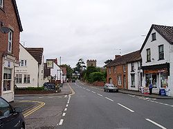
Eckington is renowned for Eckington Bridge, which is the subject of a poem by Arthur Quiller-Couch, [1] its village cross and its Norman-period church. It has a school, the Eckington Church of England First School, a recreation centre and scout hut with surrounding recreation grounds, home to the village's football and cricket teams, and a village hall. In 2023, Community Fields were opened, with paths for walking, grassed and wild flower areas, and plans for a memorial garden near to the cemetery.

Eckington has a village shop and 2 hairdressers. It currently has two pubs The Bell and The Anchor, both offering food and guest accommodation; a third pub, The Crown, closed in the early 1990s.

Eckington railway station was located on the Bristol to Birmingham Line main railway line. It closed in January 1965.

One of the Pilgrim Fathers, George Soule, is believed to have come from the village. [2] [3]

History

The Grade II listed village cross now stands in a grass triangle at the junction of Church Street and Drakes Bridge Road 52°4'18.83"N+2°6'56.28"W . It was moved to there when restored in 1897, and given a Maltese Cross. The base and shaft are medieval with Victorian inscriptions on North & South faces of the shaft, the former barely visible. The Inscription reads:

DOMINE•SALVAM•FAC•REGINAM•MDCCCXCVII (God Save the Queen 1897).

Related Research Articles

<span class="mw-page-title-main">Stratford-upon-Avon</span> Town in Warwickshire, England

Stratford-upon-Avon, commonly known as just Stratford, is a market town and civil parish in the Stratford-on-Avon district, in the county of Warwickshire, in the West Midlands region of England. It is situated on the River Avon, 91 miles (146 km) north-west of London, 22 miles (35 km) south-east of Birmingham and 8 miles (13 km) south-west of Warwick. The town is the southernmost point of the Arden area on the edge of the Cotswolds. In the 2021 census Stratford had a population of 30,495.

<span class="mw-page-title-main">Bredon</span> Village in Worcestershire, England

Bredon is a village and civil parish in Wychavon district at the southern edge of Worcestershire in England. It lies on the banks of the River Avon on the lower slopes of Bredon Hill.

<span class="mw-page-title-main">Burbage, Wiltshire</span> Human settlement in England

Burbage is a village and civil parish in the Vale of Pewsey, Wiltshire, England. It is about 6 miles (9.7 km) south of Marlborough and 20 miles (32 km) west of Newbury.

<span class="mw-page-title-main">Bidford-on-Avon</span> Village in Warwickshire, England

Bidford-on-Avon is a large village and civil parish in the English county of Warwickshire, very close to the border with Worcestershire. In the 2001 census it had a population of 4,830, increasing to 5,350 at the 2011 census, increasing again to 6,818 in the 2021 census.

<span class="mw-page-title-main">Congresbury</span> Human settlement in England

Congresbury is a village and civil parish on the northwestern slopes of the Mendip Hills in North Somerset, England, which in 2011 had a population of 3,497. It lies on the A370 between Junction 21 of the M5 and Bristol Airport, 13 miles (21 km) south of Bristol city centre, and 7 miles (11 km) east of Weston-super-Mare. The Congresbury Yeo river flows through the village. The parish includes the hamlet of Brinsea.

<span class="mw-page-title-main">Kempsey, Worcestershire</span> Human settlement in England

Kempsey is a village and civil parish in the Malvern Hills District in the county of Worcestershire, England. It is bounded by the River Severn on the west, and the A38 main road runs through it and is about 3 miles (5 km) south of Worcester. The village has a long history. Its name is derived from the Saxon "Kemys' Eye", or the island of Kemys. Kemys was a Saxon chief, whose island lay between marshes and the River Severn. One of the roads in Kempsey, Lyf's Lane, is named after another Saxon chief. The village was recorded in the 11th century Domesday Book as having a value of £7.

<span class="mw-page-title-main">Shiplake</span> Human settlement in England

Shiplake consists of three settlements: Shiplake, Shiplake Cross and Lower Shiplake. Together these villages form a civil parish situated beside the River Thames 2 miles (3 km) south of Henley-on-Thames, Oxfordshire, England. The river forms the parish boundary to the east and south, and also the county boundary between Oxfordshire and Berkshire. The villages have two discrete centres separated by agricultural land. The 2011 Census records the parish population as 1,954 and containing 679 homes. The A4155 main road linking Henley with Reading, Berkshire passes through the parish.

<span class="mw-page-title-main">Woolhampton</span> Village and civil parish in England

Woolhampton is a village and civil parish in West Berkshire, England. The village straddles the Bath Road between the towns of Reading, 8 mi (13 km) to the east, and Newbury, 6 mi (10 km) to the west.

<span class="mw-page-title-main">Bramfield, Suffolk</span> Human settlement in England

Bramfield is a village and civil parish in the east of the English county of Suffolk, and in the East Suffolk district. It is 5 miles (8.0 km) south of the market town of Halesworth on the A144 road between Halesworth and the A12 road, one of the main arterial routes through the county. The village is 24 miles (39 km) north-east of the county town of Ipswich and 15 miles (24 km) south-west of the port of Lowestoft. The East Suffolk railway line between Lowestoft and Ipswich passes close to the west of the village with Halesworth railway station being the nearest station.

<span class="mw-page-title-main">Cropthorne</span> Human settlement in England

Cropthorne is a village and civil parish in Worcestershire, England within the Vale of Evesham, and on the North-west edge of the Cotswolds. It is approximately 13 miles (21 km) southeast of Worcester, 19 miles (31 km) north of Cheltenham, and 18 miles (29 km) southwest of Stratford-upon-Avon. Cropthorne has a population of 603, in 237 households. Located on a small ridge overlooking the River Avon, its ancient orchards sweep down to the river and offer clear, unbroken views across the vale to the Malvern Hills in the distance. It is featured in the Domesday Book, and St Michael's Church dates back to the 12th century. The church is a Grade I listed building. The village has many unique examples of timber-framed thatched cottages from the 16th and 17th centuries, and about half the village is designated as a Conservation area. The village has a Site of Special Scientific Interest, Cropthorne New Inn Section.

Little Haywood is a village in Staffordshire, England. For population details as taken at the 2011 census see under Colwich. It lies beside a main arterial highway, the A51 but traffic through the village is mainly light, owing to this bypass. Nearby also is the West Coast Main Line railway, the Trent and Mersey Canal and beside it, the river Trent. Little Haywood is about 125 miles (201 km) northwest of London, about 25 miles (40 km) north of Birmingham, 4 miles (6.4 km) northwest of Rugeley and 6 miles (9.7 km) east of Stafford.

<span class="mw-page-title-main">Milton Lilbourne</span> Human settlement in England

Milton Lilbourne is a village and civil parish in the county of Wiltshire, England, in the Vale of Pewsey between Pewsey and Burbage. It is largely a mixed residential area centred on the Manor. The nearest town is Marlborough, 5.5 miles (8.9 km) to the north.

<span class="mw-page-title-main">Honing, Norfolk</span> Village in Norfolk, England

Honing is a village and a civil parish in the English county of Norfolk. The village is 15 miles (24 km) north-northeast of Norwich, 13 miles (21 km) south east of Cromer and 4 miles (6.4 km) east of North Walsham.

<span class="mw-page-title-main">Wixford</span> Human settlement in England

Wixford is a hamlet and civil parish in the Stratford-on-Avon District of Warwickshire, England, situated 1.5 miles (2.4 km) south of Alcester. The population at the 2011 census was 155. The area is largely agricultural with no large employers in the area, most residents commuting to larger towns nearby.

<span class="mw-page-title-main">Church Lawford</span> Human settlement in England

Church Lawford is a village and civil parish in Warwickshire, England. It is located just under 2.5 miles (4 km) west of the town of Rugby and 4.5 miles (7 km) east of Coventry. The population of the civil parish taken at the 2021 census was 432.

<span class="mw-page-title-main">Leigh, Staffordshire</span> Human settlement in England

Leigh is a civil parish in the English county of Staffordshire. The parish includes the village of Church Leigh, together with the settlements of Withington, Upper Leigh, Lower Leigh, Morrilow Heath, Middleton Green, Dodsley, Godstone, Nobut and Field.

<span class="mw-page-title-main">West Walton</span> Human settlement in England

West Walton is a village and civil parish in the King's Lynn and West Norfolk District of Norfolk, England.

<span class="mw-page-title-main">Strensham</span> Human settlement in England

Strensham is a village in the Wychavon district of Worcestershire. In the 2001 census, the civil parish of Strensham had a population of 314 across 127 households. Since 1991, the population has risen 28.7% from 244 residents.

<span class="mw-page-title-main">Eckington Bridge</span> Bridge in Worcestershire, England

Eckington Bridge is a stone bridge over the River Avon in Eckington in the English county of Worcestershire. It is a Grade II* listed building and has been scheduled as an ancient monument.

<span class="mw-page-title-main">Bow Brook</span> River in Worcestershire, England

The Bow Brook is a substantial brook that flows for 28.8 miles (46.3 km) through Worcestershire, England. It is a lower tributary of the River Avon which it joins near Defford downstream of Eckington Bridge. Its principal tributaries include the Stoulton, Dean, and Seeley brooks.

References

  1. "Upon Eckington Bridge, River Avon - by A.T. Quiller-Couch".
  2. Genealogy page
  3. "ditto". Archived from the original on 12 January 2011. Retrieved 13 July 2009.

Commons-logo.svg Media related to Eckington, Worcestershire at Wikimedia Commons