
Clovelly is a harbour village in the Torridge district of Devon, England. Its steep pedestrianised cobbled main street, traditional architecture, donkeys and views over the Bristol Channel attract numerous tourists. At the 2011 census, the parish population was 443, which was 50 fewer than ten years previously. The ward of Clovelly Bay includes the island of Lundy.

Bishop's Hull is a village and civil parish in Somerset, England, situated in the western suburbs of Taunton in the Somerset West and Taunton district. It includes the areas of Rumwell, Rumwell Park, Roughmoor and Longaller and is close to the River Tone. The parish, which includes the hamlet of Netherclay, has a population of 2,975 in total.

Stoke St Gregory is a village and civil parish in Somerset, England, about 7 miles (11 km) east of Taunton in the Somerset West and Taunton district. The village is on a low ridge of land between the River Tone to the north and West Sedgemoor to the south. The 2011 Census recorded the parish's population as 942.
Swalcliffe is a village and civil parish about 5 miles (8 km) west of Banbury in Oxfordshire. The parish is about 2+1⁄2 miles (4 km) long north–south and about 1 mile (1.6 km) east–west. The 2011 Census recorded the population of the modern Swalcliffe parish as 210. The toponym "Swalcliffe" comes from the Old English swealwe and clif, meaning a slope or cliff frequented by swallows. The ancient parish of Swalcliffe was larger than the present civil parish, and included the townships of Epwell, Shutford, Sibford Ferris and Sibford Gower.

Ab Lench is a village in Worcestershire, England. The village lies 1 mile (1.6 km) from Church Lench and Rous Lench, 2 miles (3 km) from Harvington and 4 miles (6.4 km) from Ragley Hall. It is about 15 miles (24 km) from Stratford and 6 miles (10 km) from Evesham.

Acton is a small village and civil parish lying immediately west of the town of Nantwich in the unitary authority of Cheshire East and the ceremonial county of Cheshire, England. The civil parish covers 762 acres (3.08 km2) and also includes the small settlement of Dorfold and part of Burford, with an estimated population of 340 in 2006. It is administered jointly with the adjacent civil parishes of Henhull and Edleston. Historically, Acton refers to a township and also to an ancient parish in the Nantwich Hundred covering a wide area to the west of Nantwich. The area is agricultural, with dairy farming the main industry. Around a third of the area falls within the Dorfold Estate. Historically, agriculture was the major employer, but it has now been overtaken by the service industries, with many residents commuting significant distances outside the parish to work.
Prestbury is a village and civil parish in Cheshire, England, about 1.5 miles (3 km) north of Macclesfield. At the 2001 census, it had a population of 3,324; it increased slightly to 3,471 at the 2011 census. Alongside fellow "Cheshire Golden Triangle" villages, Wilmslow and Alderley Edge, it is one of the more sought-after places in the north. The ecclesiastical parish is almost the same as the former Prestbury local government ward which consisted of the civil parishes of Prestbury, Adlington and Mottram St Andrew.

Bourton-on-Dunsmore is a small village in Warwickshire, England. It is within the civil parish of Bourton and Draycote, along with the nearby hamlet of Draycote. Bourton is part of the borough of Rugby and is located around 5 miles (8.0 km) south-west of the town of Rugby, just south of the B4453 road. Bourton is located upon a ridge of high ground overlooking the Draycote Water reservoir. A short distance to the east, downhill of Bourton is the hamlet of Draycote, and a short distance west is the village of Frankton. Bourton-on-Dunsmore was mentioned in the Domesday Book. The village church of St Peter dates to the 13th century, but was mostly rebuilt in the 19th century, it is now grade II listed.
Mutford is a village and civil parish in the East Suffolk District of the English county of Suffolk. The village is 5 miles (8.0 km) south-west of Lowestoft and 4 miles (6.4 km) south-east of Beccles in a rural area. The parish borders Barnby, Carlton Colville, Gisleham, Rushmere, Henstead with Hulver Street, Ellough and North Cove. The village gave its name to the Half Hundred of Mutford which is named in the Domesday Book.

West Bradley is a village and civil parish 4 miles south-east of Glastonbury in the Mendip district of Somerset, England. The parish includes the hamlets of Hornblotton and Lottisham.
Woodnesborough is a village in the Dover District of Kent, England, 2 miles (3.2 km) west of Sandwich. The population taken at the 2011 census included Coombe as well as Marshborough, and totalled 1,066. There is a Grade II* listed Anglican church dedicated to St Mary the Virgin.

Church Lench is a village in the civil parish of South Lenches, in the Wychavon district, in the county of Worcestershire, England, approximately 5.5 miles due north of Evesham and 13 miles due west of Stratford-upon-Avon. It is the largest of the surrounding Lenches, accommodating the Lenches Sports Club, the Lenches Members' Club, Church Lench First School, Church Lench preschool and the Church Lench Village Hall.

Balscote or Balscott is a village in the civil parish of Wroxton, Oxfordshire, about 4 miles (6.4 km) west of Banbury. The Domesday Book of 1086 records the place-name as Berescote. Curia regis rolls from 1204 and 1208 record it as Belescot. An entry in the Book of Fees for 1242 records it as Balescot. Its origin is Old English, meaning the cottage, house or manor of a man called Bælli.

Cornwell is a small village and civil parish about 2.5 miles (4 km) west of Chipping Norton in the West Oxfordshire district of Oxfordshire, on the county border with Gloucestershire. The 2001 Census recorded the parish's population as 66.
Taunton Deane is a local government district with borough status in the English county of Somerset. In the United Kingdom, the term listed building refers to a building or other structure officially designated as being of special architectural, historical or cultural significance; Grade I structures are those considered to be "buildings of exceptional interest". Listing was begun by a provision in the Town and Country Planning Act 1947. Once listed, severe restrictions are imposed on the modifications allowed to a building's structure or its fittings. In England, the authority for listing under the Planning Act 1990 rests with Historic England, a non-departmental public body sponsored by the Department for Digital, Culture, Media and Sport; local authorities have a responsibility to regulate and enforce the planning regulations.

Nowton is a small village and civil parish in the West Suffolk district of Suffolk in eastern England. Located on the southern edge of Bury St Edmunds, in 2005 its population was estimated to be 140. At the 2011 census 163 people were recorded as living in the village.

Langton by Spilsby, sometimes called Langton by Partney, is a village and civil parish in the East Lindsey district of Lincolnshire, England. It is situated approximately 4 miles (6 km) north from the town of Spilsby, Lincolnshire. The civil parish includes the hamlet of Sutterby. From the 2011 census the population is included in the civil parish of Sausthorpe.

Toynton St Peter is a village and civil parish in the East Lindsey district of Lincolnshire, England, approximately 2 miles (3 km) south from the town of Spilsby.

There are 48 Grade I listed buildings in Greater Manchester, England. In the United Kingdom, the term listed building refers to a building or other structure officially designated as being of special architectural, historical or cultural significance; Grade I structures are those considered to be "buildings of exceptional interest". In England, the authority for listing under the Planning Act 1990 rests with Historic England, a non-departmental public body sponsored by the Department for Culture, Media and Sport.
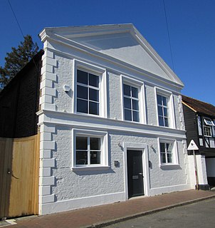
The former Salvation Army Hall in Godalming, Surrey, England, now an office building known as Aurum House, has been used by three religious groups since its construction c. 1830. The ancient town in the English county of Surrey has a long and diverse history of Protestant Nonconformity, and three Nonconformst denominations are represented: at first it served Congregationalists, but when they built a larger chapel in the town it passed to the Methodist Church. In the 20th century it was occupied by The Salvation Army, but it closed in 2012 and was redeveloped for commercial use. The building has been listed at Grade II for its architectural and historical importance.

