
The Duddon Valley is a valley in the Lake District National Park in Cumbria, England. The River Duddon flows through the valley, rising in the mountains between Eskdale and Langdale, before flowing into the Irish Sea near Broughton in Furness. In its lower reaches it is bounded by the Furness Fells and Harter Fell.
Walna Scar is a hill in the English Lake District, lying just south of a pass of the same name in the Coniston Hills. Its summit at 2,035 feet (620 m) is only slightly higher than the pass.

Orrest Head is a hill in the English Lake District on the eastern shores of Windermere. It is the subject of a chapter in Wainwright's The Outlying Fells of Lakeland, and the first fell he climbed. He describes it as "our first ascent in Lakeland, our first sight of mountains in tumultuous array across glittering waters, our awakening to beauty" and also as "a fitting finale, too, to a life made happy by fellwandering".

Cold Fell is a hill in the west of the English Lake District. It is easily climbed from the road between Ennerdale Bridge and Calder Bridge. This road is in fact known as Cold Fell Road and is used by many Sellafield employees living in Cockermouth.

School Knott is a hill in the Lake District, England, to the east of Windermere town, Cumbria. It is the subject of a chapter of Wainwright's book The Outlying Fells of Lakeland. His recommended route starts at Windermere railway station and includes Grandsire at 818 feet (249 m) and a nameless summit at 806 feet (246 m). The summit is at 760 feet (230 m) and offers a view of four sections of Windermere, the lake. It has a rocky outcrop but no trig point and, as reported by Wainwright, no cairn. Schoolknott Tarn is to the south-east of the summit.

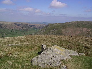
Hesk Fell is a hill in the south-west of the English Lake District, between the Duddon Valley and Eskdale near Ulpha, Cumbria. It is the subject of a chapter of Wainwright's book The Outlying Fells of Lakeland. It reaches 1,566 feet (477 m) and Wainwright's route, an anticlockwise circuit from the Birker Fell road, also visits The Pike at 1,214 feet (370 m). Wainwright admits that the fell "has many shortcomings" and that the view of Scafell Pike and its neighbours is "the only reward for the ascent".

The Naddle Horseshoe is a group of summits in the English Lake District, south of Mardale valley, Cumbria. It is the subject of a chapter of Wainwright's book The Outlying Fells of Lakeland.

Bigland Barrow is a hill in the English Lake District, near Backbarrow, Cumbria. It is the subject of a chapter of Wainwright's book The Outlying Fells of Lakeland. It reaches 630 feet (190 m), and there is a concrete lookout tower on the summit which Wainwright describes as "a wartime relic". Wainwright's route is an anticlockwise circuit from Newby Bridge.
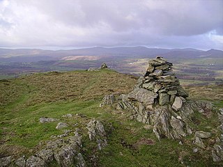
Blawith Knott is a hill in the south of the English Lake District, near Woodland, Cumbria. It is the subject of a chapter of Wainwright's book The Outlying Fells of Lakeland. It reaches 806 feet (246 m) and Wainwright's clockwise route from the fell road to the south-west also includes Tottlebank Height at 775 feet (236 m). He describes Blawith Knott as "a magnificent viewpoint", with both a panorama of Lake District fells to the north and, to the east to south, views which, on a clear day, include the Howgill Fells, Whernside and Ingleborough.

Brant Fell is a hill in the English Lake District, near Bowness-on-Windermere, Cumbria. It is the subject of a chapter of Wainwright's book The Outlying Fells of Lakeland. It reaches 629 feet (192 m). Wainwright's route leaves Bowness along the path of the Dales Way, makes an anticlockwise loop over the viewpoint of Post Knott to the summit, and either returns along the Dales Way or follows a woodland path to Helm Road from where another viewpoint, Biskey Howe, is only a slight detour before continuing down Helm Road to Bowness. He commends its "fine prospect of Windermere".

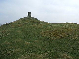
Seat Robert is a hill in the east of the English Lake District, south west of Shap, Cumbria. It is the subject of a chapter of Wainwright's book The Outlying Fells of Lakeland. It reaches 1,688 feet (515 m), and has a cairn and an Ordnance Survey "ring" at ground level rather than the usual trig point column. Wainwright's route is a clockwise circuit from Swindale reaching Seat Robert by way of Langhowe Pike at 1,313 feet (400 m) and Great Ladstones at 1,439 feet (439 m), and continuing over High Wether Howe at 1,705 feet (520 m) and Fewling Stones and 1,667 feet (508 m). The first section of his route follows the Old Corpse Road, a corpse road, along which corpses were carried from Mardale to be buried at Shap.

Finsthwaite Heights is an upland area in the English Lake District, above Finsthwaite, Cumbria. It is the subject of a chapter of Wainwright's book The Outlying Fells of Lakeland. It reaches about 600 feet (180 m). Wainwright's walk starts from Newby Bridge, climbs through woodland passing a tower which has a 1799 inscription commemorating the Royal Navy, passes through the village, and climbs to the man-made tarns of Low Dam and High Dam. These were made to provide power for Stott Park Bobbin Mill. Wainwright says of his route: "Everywhere the surroundings are delightful. But this is not fellwalking."

Heughscar Hill is a hill in the east of the English Lake District, east of Ullswater and north of High Street, Cumbria. It is the subject of a chapter of Wainwright's book The Outlying Fells of Lakeland. It reaches 1,231 feet (375 m) and Wainwright's route is an anticlockwise circuit starting at Askham. He describes it as "A gem for aged fellwalkers"'.
Howes is a subsidiary summit of Branstree in the English Lake District, south east of Selside Pike in Cumbria. It is the subject of a chapter of Wainwright's book The Outlying Fells of Lakeland. Wainwright's route starts at Swindale Head and follows Swindale Beck, then passes over Nabs Moor at 1,613 feet (492 m) to reach the summit of Howes at 1,930 feet (590 m), dropping down to Mosedale Beck to complete an anticlockwise circuit. Wainwright states that Howes is "merely a subsidiary and undistinguished summit on the broad eastern flank of Barnstree. There is nothing exciting about it ..." but commends the sight of Mosedale quarry and the waterfalls of Swindale Head which he describes as "extremely fine, up to Lodore standard".

Great Worm Crag is a hill in south west of the English Lake District, north of Ulpha, Cumbria. It is the subject of a chapter of Wainwright's book The Outlying Fells of Lakeland. It reaches a height of 1,400 feet (430 m) and Wainwright's route is a clockwise circuit from the fell road between Ulpha and Eskdale Green. Mark Richards in his Fellrangers book series describes it as "A lovely place to roam ... blessed with spacious views" and offers two ascent routes from the south west and one, via Birkerthwaite, from the north west.
High Knott, marked on some Ordnance Survey maps as Williamson's Monument, is a hill in the eastern part of the English Lake District, near Staveley, Cumbria. The monument on its summit was built by the Reverend T. Williamson in 1803, in memory of his father Thomas Williamson, who had climbed the fell every day before breakfast. The fell is the subject of a chapter of Wainwright's book The Outlying Fells of Lakeland. It reaches 901 feet (275 m) and Wainwright's route starts near the 17th-century Ulthwaite Bridge on the River Kent, climbing High Knott and then making a clockwise circuit to the early British village site at Hugill and "over the pleasant heights on the west side of mid-Kentmere".

Hugill Fell is a hill in the English Lake District, near Staveley, Cumbria, on the western side of the Kentmere valley. It is the subject of a chapter of Wainwright's book The Outlying Fells of Lakeland. It reaches 840 feet (260 m) and Wainwright's walk is an ascent from Staveley and return on the same route. There is a cairn on the summit.

Irton Pike is a hill in the west of the English Lake District, near Santon Bridge, Cumbria. It is the subject of a chapter of Alfred Wainwright's book The Outlying Fells of Lakeland. The hill reaches a height of 751 feet (229 m). Wainwright's walk as described in Lakeland is an anticlockwise circuit from Irton Road station on the Ravenglass and Eskdale Railway, near Eskdale Green. He describes "this tiny top" as "a near-perfect solace for reminiscences of past happy days on the higher fells", adding "Climb Irton Pike while ye may!"
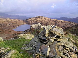
Woodland Fell is an upland area in the south of the English Lake District, south of Torver, Cumbria. It is the subject of a chapter of Wainwright's book The Outlying Fells of Lakeland. Wainwright's route is a clockwise circuit from the hamlet of Woodland, and includes the summits of Yew Bank at 678 feet (207 m) and Wool Knott at 730 feet (220 m), with Beacon Tarn between them. He describes the walk as: "a connoisseur's piece, every step an uninhibited joy, every corner a delight."
Staveley Fell is an upland area in the English Lake District, near Staveley-in-Cartmel, Cumbria, east of the southern end of Windermere. It is the subject of a chapter of Wainwright's book The Outlying Fells of Lakeland, but he admits that: "Strictly it has no name, not even locally, being referred to on Ordnance maps as Astley's and Chapel House Plantations, which are new forests severely encroaching upon it". He says it "commands a fine aerial view of the foot of Windermere." The fell reaches 870 feet (270 m) and Wainwright's route is a clockwise loop starting from Staveley-in-Cartmel. Chris Jesty in his revised edition of Wainwright's book provides an alternative route and comments that "There must be many people who, encouraged by the ordnance Survey map, or by the first edition of this book, have ... been turned back by an uncrossable fence."
