
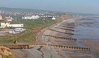
The Lake District, also known as the Lakes or Lakeland, is a mountainous region and national park in Cumbria, North West England. It is famous for its landscape, including its lakes, coast, and the Cumbrian mountains; and for its literary associations with Beatrix Potter, John Ruskin, and the Lake Poets.
Alfred Wainwright MBE, who preferred to be known as A. Wainwright or A.W., was a British fellwalker, guidebook author and illustrator. His seven-volume Pictorial Guide to the Lakeland Fells, published between 1955 and 1966 and consisting entirely of reproductions of his manuscript, has become the standard reference work to 214 of the fells of the English Lake District. Among his 40-odd other books is the first guide to the Coast to Coast Walk, a 182-mile (293-kilometre) long-distance footpath devised by Wainwright which remains popular today.
The Coast to Coast Walk is a long-distance footpath between the west and east coasts of Northern England, nominally 190-mile (306 km) long. Devised by Alfred Wainwright, it passes through three contrasting national parks: the Lake District National Park, the Yorkshire Dales National Park, and the North York Moors National Park. The current actual measured distance is reported as 182-mile (293 km).

Haweswater is a reservoir in the valley of Mardale, Cumbria in the Lake District, England. Work to raise the height of the original natural lake was started in 1929. It was controversially dammed after the UK Parliament passed a Private Act giving Manchester Corporation permission to build the reservoir to supply drinking water to the city. The decision caused a public outcry because the farming villages of Measand and Mardale Green would be flooded and the valley altered forever.
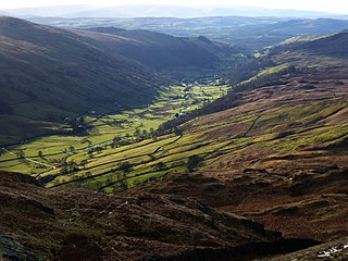
Longsleddale is a valley and civil parish in the South Lakeland district of Cumbria, England. It includes the hamlet of Sadgill. The parish has a population of 73. As the population taken at the 2011 Census was less than 100, details are maintained in the civil parish of Whitwell and Selside.

High Street is a fell in the English Lake District. At 828 metres (2,717 ft), its summit is the highest point in the far eastern part of the national park. The fell is named after the Roman road that ran over the summit.

Bampton is a village and civil parish in the Westmorland and Furness unitary authority area of Cumbria, England, on the edge of the Lake District National Park. It is in the historic county of Westmorland. The parish had a population of 283 according to the 2001 census. In the 2011 census Bampton was grouped with Martindale to give a total of 373. The parish includes the villages of Bampton, Bampton Grange and Bomby.

The River Lowther is a small river which flows through limestone rock in Cumbria, England. It is a tributary of the River Eamont which in turn is a tributary of the River Eden which flows into the Solway Firth near Carlisle. The Lowther begins with the confluence of the Keld Gill and the Keld Dub near the village of Keld. It flows north-west until it passes between Bampton and Bampton Grange, before turning north until it flows into the River Eamont close to Penrith.

The River Irt is a river in the county of Cumbria in northern England. It flows for 14 miles (22 km) from the south-western end of Wast Water, the deepest lake in England, leaving the lake at the foot of Whin Rigg, the southern peak of the famous Wastwater Screes. The name of the river is believed to derive either from the Old English gyr which means "mud", or from the Brittonic words *ar, "flowing", or *īr, "fresh, clean, pure", suffixed with -ed, a nominal suffix meaning "having the quality of...".

The River Greta is a river in Cumbria, England. It is a tributary of the River Derwent and flows through the town of Keswick. "Greta" derives from the Old Norse "Griótá", meaning "stony stream". The name is in records dating from the early 13th century, and also appears in Latinised form, as "Gretagila", at the time of Magna Carta.

Seat Sandal is a fell in the English Lake District, situated four kilometres north of the village of Grasmere from where it is very well seen. Nevertheless, it tends to be overshadowed by its more illustrious neighbours in the Eastern Fells, Helvellyn and Fairfield.
Loadpot Hill is a fell in the English Lake District, between Haweswater and Ullswater.

Wether Hill is a fell in the English Lake District, between Martindale and Haweswater. It lies on the main north-south ridge of the Far Eastern Fells between Loadpot Hill and High Raise. Lesser ridges also radiate out to the east and north-west. It should not be confused with Wether Hill in north Northumberland.

High Raise is a fell in the English Lake District, standing to the west of Haweswater Reservoir in the Far Eastern Fells. Note that another High Raise is the highpoint of the Central Fells.
Selside Pike or Selside is a fell in the English Lake District. It stands between the valleys of Mardale and Swindale in the Far Eastern Fells.
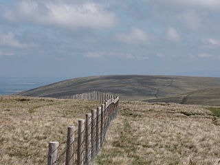
The Far Eastern Fells are a part of the Cumbrian Mountains in the Lake District of England. Reaching their highest point at High Street, they occupy a broad area to the east of Ullswater and Kirkstone Pass. Much quieter than the central areas of Lakeland they offer in general easier walking as the fells merge mainly into the surrounding moorlands.

Bampton Grange is a village in Cumbria, England.

Seathwaite is a small hamlet in the Borrowdale civil parish of Cumberland, Cumbria, North West England. It is in the Lake District near Scafell Pike and 8 miles (13 km) southwest of Keswick at the end of a minor road that heads southwest from the hamlet of Seatoller, which is where the B5289 road begins its steep climb up the pass to Honister Hause on the boundary between Borrowdale civil parish and Buttermere civil parish.

Martindale is a valley, village and civil parish in Cumbria, England, situated within the Lake District National Park between the lakes of Ullswater and Haweswater. The valley is served by a narrow minor road which runs as far as the farm of Dale Head. This road commences at Howtown, a hamlet on the shore of Ullswater that forms part of the civil parish but is not in the valley of Martindale, and passes over a mountain pass or hause into the valley.
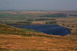
Wet Sleddale Reservoir is an artificial reservoir set amongst the Shap Fells 4 kilometres (2 mi) south of the village of Shap in Cumbria, England, and lies just within the boundary of the Lake District National Park. The triangular shaped reservoir, which can store 2,300 million litres of water, was created by the construction of a dam across Sleddale Beck in order to supply Manchester with water. The dam is 21m high and 600m long.


