
Wharfedale is the valley of the upper parts of the River Wharfe and one of the Yorkshire Dales. It is situated within the districts of Craven and Harrogate in North Yorkshire, and the cities of Leeds and Bradford in West Yorkshire. It is the upper valley of the River Wharfe. Towns and villages in Wharfedale include Buckden, Kettlewell, Conistone, Grassington, Hebden, Bolton Abbey, Addingham, Ilkley, Burley-in-Wharfedale, Otley, Pool-in-Wharfedale, Arthington, Collingham and Wetherby. Beyond Wetherby, the valley opens out and becomes part of the Vale of York.

The Yorkshire Dales is an upland area of the Pennines in the historic county of Yorkshire, England, most of it in the Yorkshire Dales National Park created in 1954.
The mountains of Whernside, Ingleborough and Pen-y-ghent are collectively known as the Three Peaks. The peaks, which form part of the Pennine range, encircle the head of the valley of the River Ribble in the Yorkshire Dales National Park in the North of England.
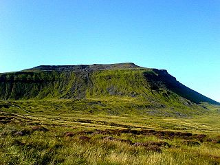
Ingleborough is the second-highest mountain in the Yorkshire Dales, England. It is one of the Yorkshire Three Peaks, and is frequently climbed as part of the Three Peaks walk. A large part of Ingleborough is designated as a Site of Special Scientific Interest and National Nature Reserve and is the home of a new joint project, Wild Ingleborough, with aims to improve the landscape for wildlife and people.

Ingleton is a village and civil parish in the Craven district of North Yorkshire, England. The village is 19 miles (30 km) from Kendal and 17 miles (28 km) from Lancaster on the western side of the Pennines. It is 9.3 miles (15 km) from Settle. The River Doe and the River Twiss meet to form the source of the River Greta, a tributary of the River Lune. The village is on the A65 road and at the head of the A687. The B6255 takes the south bank of the River Doe to Ribblehead and Hawes. All that remains of the railway in the village is the landmark Ingleton Viaduct. Arthur Conan Doyle was a regular visitor to the area and was married locally, as his mother lived at Masongill from 1882 to 1917. It has been claimed that there is evidence that the inspiration for the name Sherlock Holmes came from here.

Hardraw Force is a waterfall on Hardraw Beck in Hardraw Scar, a wooded ravine just outside the hamlet of Hardraw, 0.9 miles (1.5 km) north of the town of Hawes, Wensleydale, in the Yorkshire Dales. The Pennine Way long distance footpath passes close by.
A reef knoll is a land-based landform that comprises an immense pile of calcareous material that accumulated on a previously existing ancient sea floor. At the time of its accumulation it may have had enough structure from organisms such as sponges to have been free-standing and to withstand the sea currents as material accumulated, and was likely an atoll. Another possibility is the remains of deep water coral. Such structures are thus often fossil-rich.

Millstone Grit is the name given to any of a number of coarse-grained sandstones of Carboniferous age which occur in the British Isles. The name derives from its use in earlier times as a source of millstones for use principally in watermills. Geologists refer to the whole suite of rocks that encompass the individual limestone beds and the intervening mudstones as the Millstone Grit Group. The term Millstone Grit Series was formerly used to refer to the rocks now included within the Millstone Grit Group together with the underlying Edale Shale Group.
The Hangenberg event, also known as the Hangenberg crisis or end-Devonian extinction, is a mass extinction that occurred at the end of the Famennian stage, the last stage in the Devonian Period. It is usually considered the second-largest extinction in the Devonian Period, having occurred approximately 13 million years after the Late Devonian mass extinction at the Frasnian-Famennian boundary. The Hangenberg event was an anoxic event marked by a layer of black shale, and it has been proposed to have been related to a rapid sea-level fall from the last phase of the Devonian Southern Hemisphere glaciation. It has also been suggested to have been linked to an increase in terrestrial plant cover. That would have led to increased nutrient supply in rivers and may have led to eutrophication of semi-restricted epicontinental seas and could have stimulated algal blooms. However, support for a rapid increase in plant cover at the end of the Famennian is lacking. The event is named after the Hangenberg Shale, which is part of a sequence that straddles the Devonian-Carboniferous boundary in the Rhenish Massif of Germany.
Langcliffe Pot is a cave system on the slopes of Great Whernside in Upper Wharfedale, about 3 kilometres (1.9 mi) SSE of Kettlewell in North Yorkshire. It is part of the Black Keld Site of Special Scientific Interest where the "underground drainage system which feeds the stream resurgence at Black Keld is one of the largest and deepest in Britain, although only a small proportion of its cave passages are accessible at present." Mossdale Caverns is also part of the Black Keld SSSI. Although a considerable length of passage has been explored in Langcliffe Pot, the current end is over 170 metres (560 ft) above the resurgence, and over 4 kilometres (2.5 mi) in distance. A trip to the far end has been described as "one of the most serious undertakings in British Caving".

Cummingella is a genus of proetid trilobite in the family Phillipsiidae that lived from the earliest Carboniferous until the last species' extinction in the Middle Permian. Fossils have been found in corresponding marine strata of Western Europe, the United Kingdom and the United States.
The geology of Lancashire in northwest England consists in the main of Carboniferous age rocks but with Triassic sandstones and mudstones at or near the surface of the lowlands bordering the Irish Sea though these are largely obscured by Quaternary deposits.
The geology of County Durham in northeast England consists of a basement of Lower Palaeozoic rocks overlain by a varying thickness of Carboniferous and Permo-Triassic sedimentary rocks which dip generally eastwards towards the North Sea. These have been intruded by a pluton, sills and dykes at various times from the Devonian Period to the Palaeogene. The whole is overlain by a suite of unconsolidated deposits of Quaternary age arising from glaciation and from other processes operating during the post-glacial period to the present. The geological interest of the west of the county was recognised by the designation in 2003 of the North Pennines Area of Outstanding Natural Beauty as a European Geopark.

Hunts Bay Oolite is an oolitic Carboniferous limestone geological formation found in the south Wales region. It is named after Hunts Bay on the Gower peninsula, south-south west of Bishopston, where a significant amount of the limestone forms the cliffs there.
The Holkerian is a sub-stage of the Viséan stage of the International Commission on Stratigraphy (ICS) geological timescale. It is one of five sub-stages commonly used in the Viséan stage within stratigraphy by British, Irish and other geologists outside the US and Asia.

James William Davis was a British naturalist who specialised in fossil fish. He lived at Chevinedge, Halifax in Yorkshire. James William Davis was a leading member of the Yorkshire Naturalists' Union and a Fellow of the Geological Society of London.
The Tyrone Group is a lithostratigraphical term coined to refer to a particular succession of rock strata which occur in Northern Ireland within the Visean Stage of the Carboniferous Period. It comprises a series of limestones, shales and sandstones which accumulated to a thickness of 2400m in the northwest Carboniferous basin of Ireland. The type areas for the group are the Clogher Valley of County Tyrone and the Fermanagh Highlands of nearby County Fermanagh. The rocks of the group sit unconformably on older rocks of the Shanmullagh Formation of the Fintona Group which are the local representatives of the Lower Old Red Sandstone. The top of the Dartry Limestone, the uppermost part of the group, is a disconformity, above which are the layered sandstones and shales of the Meenymore Formation of the Leitrim Group. The succession continues south and west across the border into the Republic of Ireland, though different names are typically applied.

The Long Kin East Cave - Rift Pot system is a limestone cave system on the southern flanks of Ingleborough, North Yorkshire in England lying within the designated Ingleborough Site of Special Scientific Interest. Long Kin East Cave starts as a long meandering stream passage but then plummets down a 58-metre (190 ft) deep shaft when it meets a shattered fault into which Rift Pot also descends. At the bottom, the stream flows through some low canals and sumps, to eventually emerge at Austwick Beck Head in Crummackdale.
The geology of the Yorkshire Dales National Park in northern England largely consists of a sequence of sedimentary rocks of Ordovician to Permian age. The core area of the Yorkshire Dales is formed from a layer-cake of limestones, sandstones and mudstones laid down during the Carboniferous period. It is noted for its karst landscape which includes extensive areas of limestone pavement and large numbers of caves including Britain's longest cave network.
The geology of the Peak District National Park in England is dominated by a thick succession of faulted and folded sedimentary rocks of Carboniferous age. The Peak District is often divided into a southerly White Peak where Carboniferous Limestone outcrops and a northerly Dark Peak where the overlying succession of sandstones and mudstones dominate the landscape. The scarp and dip slope landscape which characterises the Dark Peak also extends along the eastern and western margins of the park. Although older rocks are present at depth, the oldest rocks which are to be found at the surface in the national park are dolomitic limestones of the Woo Dale Limestone Formation seen where Woo Dale enters Wye Dale east of Buxton.