Recreation
The Ogwen Valley, as a result of being bordered on all sides by mountainous regions, is home to many hill walkers, climbers, and campers. This level of recreational activity can at times result in people getting into trouble on the hills, and to address this problem the Ogwen Valley Mountain Rescue Organisation was set up. The work was initially started by Ron James at Ogwen Cottage outdoor pursuits centre; however, the need became great enough that mountain rescue in the area needed a full-time body to be initiated.
Clwb Rygbi Bethesda (Bethesda Rugby Club) is one of the centres of social life in the valley and many boys and girls play rugby from a young age. There is also a successful Football Club and Cricket Club along with a Bowling Green in the valley, and a council-run Leisure Centre. Combine they cater for all sports, ages and abilities imaginable.
The longest zip wire (Zip World) in Europe has been extremely successful since it opened in the valley and attracts adventurers from all over the world.
People
The northern parts of the valley include the small town of Bethesda, notable for the slate quarry, which was previously owned by Lord Douglas Penrhyn and gave Penrhyn quarry its name. It also includes smaller villages such as Tregarth, Mynydd Llandygai Rachub, Sling, Caerneddi, Braichmelyn, Gerlan, Henbarc and Llanllechid. At its peak in the early 20th century, over 20,000 people lived in the valley, but this has now declined to around 6500. Three-quarters of inhabitants are able to speak Welsh. According to the Welsh Index of Multiple Deprivation, all wards in the valley are amongst the poorest 10% in Wales, with one ward among the poorest 3%.
Ysgol Dyffryn Ogwen is the secondary school for the entire valley, with pupil streams coming mainly for Ysgol Llanllechid, Ysgol Tregarth, Ysgol Mynydd Llandegai and Ysgol Pen y Bryn.

Snowdonia, or Eryri, is a mountainous region and national park in North Wales. It contains all 15 mountains in Wales over 3000 feet high, including the country's highest, Snowdon, which is 1,085 metres (3,560 ft) tall. These peaks are all part of the Snowdon, Glyderau, and Carneddau ranges in the north of the region. The shorter Moelwynion and Moel Hebog ranges lie immediately to the south.

Bethesda is a town and community in Gwynedd, Wales. It is on the banks of Afon Ogwen and on the edge of Snowdonia. It is about 5 miles (8 km) south-west of Bangor.

The Glyderau are a mountain group in Snowdonia, North Wales. The name derives from the highest peaks in the range, Glyder Fawr and Glyder Fach. According to Sir Ifor Williams, the word "Glyder" derives from the Welsh word "Cludair", meaning a heap of stones.

Ogwen Cottage Outdoor Pursuits Centre is situated beside Llyn Ogwen, in Gwynedd, Wales. It is owned by the National Trust, who bought the property at auction in October 2014 for £450,000. It was formerly for many years part of Birmingham City Council's Outdoor Learning Service, providing outdoor education, and with links to the climbing community.
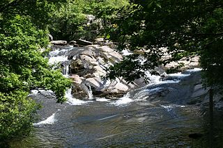
Afon Ogwen is a river in north-west Wales draining from some of the greatest peaks in Snowdonia before discharging to the sea on the eastern side of Bangor, Gwynedd.

The Nantlle Valley is an area in Gwynedd, North Wales, characterised by its numerous small settlements.

The Penrhyn Quarry Railway was a narrow-gauge railway in Caernarfonshire, Wales. It served the Penrhyn quarry near Bethesda, taking their slate produce to Port Penrhyn, near Bangor. The railway was around six miles (9.7 km) long and used a gauge of 1 ft 10+3⁄4 in.

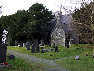
Rachub is a village of about 900 people in Dyffryn Ogwen, Gwynedd, Wales, about three-quarters of an mile (1.2 km) north of the town of Bethesda. It forms part of the Llanllechid community, which had a population of 889 in the 2011 census.

The Penrhyn quarry is a slate quarry located near Bethesda, North Wales. At the end of the nineteenth century it was the world's largest slate quarry; the main pit is nearly 1 mile (1.6 km) long and 1,200 feet deep, and it was worked by nearly 3,000 quarrymen. It has since been superseded in size by slate quarries in China, Spain and the USA. Penrhyn is still Britain's largest slate quarry but its workforce is now nearer 200.

The Nant Ffrancon Pass in Snowdonia, North Wales is at 312 metres (1,024 ft) at Pont Wern-gof, about one-third of a mile beyond the eastern end of Llyn Ogwen. The A5 road crosses it between Llyn Ogwen and Bethesda, Gwynedd.
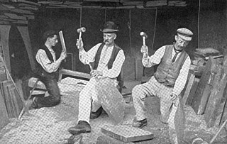
The existence of a slate industry in Wales is attested since the Roman period, when slate was used to roof the fort at Segontium, now Caernarfon. The slate industry grew slowly until the early 18th century, then rapidly during the Industrial Revolution in Wales until the late 19th century, at which time the most important slate producing areas were in northwest Wales. These sites included the Penrhyn Quarry near Bethesda, the Dinorwic Quarry near Llanberis, the Nantlle Valley quarries, and Blaenau Ffestiniog, where the slate was mined rather than quarried. Penrhyn and Dinorwig were the two largest slate quarries in the world, and the Oakeley mine at Blaenau Ffestiniog was the largest slate mine in the world. Slate is mainly used for roofing, but is also produced as thicker slab for a variety of uses including flooring, worktops and headstones.

Y Fron, also known locally as Cesarea, after the chapel, is a country village on the south-west side of Moel Tryfan, overlooking the Nantlle Valley, in North Wales, near Rhosgadfan and Carmel, on the tail of Mynydd Mawr, with epic views of Trum Y Ddysgl and Craig Cwm Silyn. It is in the community of Llandwrog.

Llanllyfni is a village and a community in Gwynedd, Wales. It is in the historic county of Caernarfonshire. The community consists of the villages of Drws-y-coed, Nantlle, Nasareth, Nebo, Penygroes, Talysarn and the village of Llanllyfni itself. Penygroes, Llanllyfni and Talysarn are almost conjoined. As an electoral ward the 2011 census recorded a population of 1256. It is a largely Welsh-speaking village as 85% of the villagers speak Welsh as their first language. The community covers 43 square kilometres.
Tregarth is a village near Thomas Telford's A5 London to Holyhead road between the town of Bethesda and the city of Bangor in Gwynedd, north Wales. It is in Llandygai Community. It had a population of over 1,300 as of the 2011 census..
Peter Prendergast was a Welsh landscape painter.
Ysgol Dyffryn Ogwen is a bilingual secondary school for pupils aged 11 to 19 years. It is situated in Bethesda in the Ogwen valley in Gwynedd, Wales. As of 2022, there were 454 pupils on roll at the school. Some of the buildings date from 1895 when a County School was established here, but the present comprehensive school dates from 1951. An extension to the school was opened by Professor Sir Idris Foster. The motto of the school is "Bydded goleuni"

Llandygai is a small village and community on the A5 road between Bangor and Talybont in Gwynedd, Wales. It affords a view of the nearby Carneddau mountain range. The population of the community taken at the 2011 Census was 2,487. Llandygai community includes nearby Tregarth and Mynydd Llandygai and also the pass of Nant Ffrancon.

The Afon Cegin is a small river draining parts of North Wales and discharging to the Menai Strait at Porth Penrhyn. Its name means Kitchen River in English.
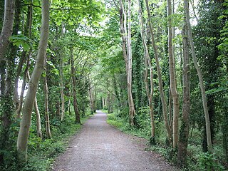
Lôn Las Ogwen is a 17.7 km (11.0 mi) cycle route in the National Cycle Network which runs south from the NCN 5 at Porth Penrhyn on the north coast of Wales to Llyn Ogwen in Snowdonia. Lôn Las is Welsh for "green lane".
