
Snowdonia, or Eryri, is a mountainous region and national park in North Wales. It contains all 15 mountains in Wales over 3000 feet high, including the country's highest, Snowdon, which is 1,085 metres (3,560 ft) tall. These peaks are all part of the Snowdon, Glyderau, and Carneddau ranges in the north of the region. The shorter Moelwynion and Moel Hebog ranges lie immediately to the south.

Snowdon, or Yr Wyddfa, is a mountain in the Snowdonia region of North Wales. It has an elevation of 1,085 metres (3,560 ft) above sea level, which makes it both the highest mountain in Wales and the highest in the British Isles south of the Scottish Highlands. Snowdon is designated a national nature reserve for its rare flora and fauna, and is located within Snowdonia National Park.
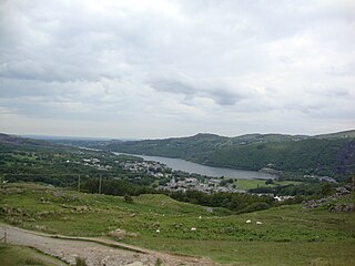
Llanberis is a village, community and electoral ward in Gwynedd, northwest Wales, on the southern bank of the lake Llyn Padarn and at the foot of Snowdon, the highest mountain in Wales. It is a centre for outdoor activities in Snowdonia, including walking, mountaineering, climbing, mountain biking and pony trekking, as well as water sports such as scuba diving. The community includes Nant Peris.

Crib Goch is described as a "knife-edged" arête in the Snowdonia National Park in Gwynedd, Wales. The name means "red ridge" in Welsh.

The Glyderau are a mountain group in Snowdonia, North Wales. The name derives from the highest peaks in the range, Glyder Fawr and Glyder Fach. According to Sir Ifor Williams, the word "Glyder" derives from the Welsh word "Cludair", meaning a heap of stones.

Glyder Fawr is a mountain in Snowdonia, Wales, the highest peak in the Glyderau range at just over 1,000 metres. It is the fifth-highest mountain in Wales and has several walking and scrambling routes leading to its summit. According to Sir Ifor Williams, the word "Glyder" derives from the Welsh word "Gludair", meaning a heap of stones.

Pen-y-Pass is a mountain pass in Snowdonia, Gwynedd, north-west Wales. It is a popular location from which to walk up Snowdon, as three of the popular routes can be started here. Glyder Fawr, to the north, is also accessible from here.

Glyder Fach is a mountain in Snowdonia, north-west Wales, and is the second highest of the Glyderau and the sixth highest in Wales. Routes to the summit lead from Tryfan and Bristly Ridge to the north, via Glyder Fawr from Pen-y-Pass to the south, and along the Glyder ridge to the east, towards Capel Curig. It is a popular spot for climbers.
Y Garn is a mountain in Snowdonia, North Wales, part of the Glyderau.

Pen-y-Gwryd is a pass at the head of Nantygwryd and Nant Cynnyd rivers close to the foot of Snowdon in Gwynedd, Wales. The area is located at the junction of the A4086 from Capel Curig to Llanberis and Caernarfon and the A498 from Beddgelert and Nant Gwynant about a mile from the head of the Llanberis Pass. It is close to the boundary with Conwy county borough in northern Snowdonia. The famous mountaineering hostelry, Pen-y-Gwryd Hotel, is located in the pass. It is also a mountain rescue post with links to the other rescue posts at Ogwen Cottage and Plas y Brenin.
The Snowdon Massif, Snowdon Range or Yr Wyddfa massif is one of the three mountain groups in Snowdonia, north Wales, to include mountains over 3,000 feet (914 m) high. It occupies the area between Beddgelert, Pen-y-Pass and Llanberis. It is surrounded by the Glyderau to the north-east, Moel Siabod to the east, the Moelwynion to the south, Moel Hebog, the Nantlle Ridge and Mynydd Mawr to the west, and by flatter land leading down to Caernarfon and the Menai Strait to the north-west.

Llynnau Mymbyr are two lakes located in Dyffryn Mymbyr, a valley running from the village of Capel Curig to the Pen-y-Gwryd hotel in Snowdonia, north-west Wales. The A4086 runs along their northern banks.

Nant Gwynant is a valley in northern Wales. The A498 road descends 600 feet (180 m) into the valley in about two miles (3 km) from Pen-y-Gwryd; it follows the Nant Cynnyd, the Afon Glaslyn and alongside Llyn Gwynant, then beside the Nant Gwynant river to Llyn Dinas and passing below Dinas Emrys to Beddgelert. The road continues through the Aberglaslyn Pass to Porthmadog.

Llyn Peris is a lake in Snowdonia, Wales, approximately 1.8 km long and situated close to the villages of Llanberis and Nant Peris, and the smaller twin of Llyn Padarn. The lake was formed glacially and is an example of a moraine-dammed lake. Llyn Peris is named after Saint Peris, an early Christian saint of whom little is known. The lake is flanked on one side by the mountain Elidir Fawr and the former slate quarry of Dinorwig. Above the opposite bank are the hills of Derlwyn and Clogwyn Mawr and a rock formation known as the Lady of Snowdon, due to its resemblance to a human face. The ruins of Dolbadarn Castle are also located on a mound above the lake.

The Nant Ffrancon Pass in Snowdonia, North Wales is at 312 metres (1,024 ft) at Pont Wern-gof, about one-third of a mile beyond the eastern end of Llyn Ogwen. The A5 road crosses it between Llyn Ogwen and Bethesda, Gwynedd.

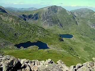
Cwm Idwal is a cirque in the Glyderau range of mountains in northern Snowdonia, the national park in the mountainous region of North Wales. Its main interest is to hill walkers and rock climbers, but it is also of interest to geologists and naturalists, given its combination of altitude, aspect (north-facing) and terrain. In a 2005 poll conducted by Radio Times, Cwm Idwal was ranked the 7th greatest natural wonder in Britain.

Dyffryn Mymbyr is a valley in Snowdonia, in north-west Wales, approximately 5 miles (8.0 km) in length, and leading up from Capel Curig to the Pen-y-Gwryd hotel.

Llechog is a top of Garnedd Ugain on the Snowdon massif in Wales. It is the top of a long crest of cliffs that start in Llanberis and finishes on Garnedd Ugain. The nearby Clogwyn Station is a stop of the Snowdon mountain railway. The summit is a rocky peak sitting out from cliffs which fall steeply down to the Nant Peris valley. The viewpoint is commanding, where the full prominence of Glyder Fawr, Y Garn, Elidir Fawr and Crib Goch can be admired.
The Snowdonia Marathon, known as Marathon Eryri from 2023, is a marathon in Snowdonia (Eryri), North Wales. It was established in 1982 as an alternative to city and town races. The route makes a circumnavigation of the Snowdon massif, starting and finishing at Llanberis. It is held annually in October.

The geology of Snowdonia National Park in North Wales is dominated by sedimentary and volcanic rocks from the Cambrian and Ordovician periods with intrusions of Ordovician and Silurian age. There are Silurian and Cenozoic sedimentary rocks on the park's margins. The succession was intensely faulted and folded during the Caledonian Orogeny. The region was uplifted as the North Atlantic Ocean opened during the Cenozoic. The current mountainous landscape arises from repeated glaciations during the Quaternary period.


