
Snowdonia, or Eryri, is a mountainous region and national park in North Wales. It contains all 15 mountains in Wales over 3000 feet high, including the country's highest, Snowdon, which is 1,085 metres (3,560 ft) tall. These peaks are all part of the Snowdon, Glyderau, and Carneddau ranges in the north of the region. The shorter Moelwynion and Moel Hebog ranges lie immediately to the south.

Snowdon, or Yr Wyddfa, is a mountain in Snowdonia in North Wales. It has an elevation of 1,085 metres (3,560 ft) above sea level, which makes it both the highest mountain in Wales and the highest in the British Isles south of the Scottish Highlands. Snowdon is designated a national nature reserve for its rare flora and fauna, and is located within Snowdonia National Park.

The A55, also known as the North Wales Expressway, is a major road in Wales and England, connecting Cheshire and North Wales. The vast majority of its length from Chester to Holyhead is a dual carriageway primary route, with the exception of the Britannia Bridge over the Menai Strait and several short sections where there are gaps in between the two carriageways. All junctions are grade separated apart from a roundabout east of Penmaenmawr and another nearby in Llanfairfechan. Initially, the road ran from Chester to Bangor. In 2001, it was extended across Anglesey to the ferry port of Holyhead parallel to the A5. The road improvements have been part funded with European money, under the Trans-European Networks programme, as the route is designated part of Euroroute E22.

Crib Goch is described as a "knife-edged" arête in the Snowdonia National Park in Gwynedd, Wales. The name means "red ridge" in Welsh.
The Crimea Pass is a mountain pass in North Wales, on the A470 road between Blaenau Ffestiniog and Dolwyddelan connecting the counties of Gwynedd and Conwy.

Abergwyngregyn is a village and community of historical note in Gwynedd, a county and principal area in Wales. Under its historic name of Aber Garth Celyn it was the seat of Llywelyn ap Gruffudd. It lies in the historic county of Caernarfonshire.
Aber Falls is a waterfall located about two miles (3 km) south of the village of Abergwyngregyn, Gwynedd, Wales.

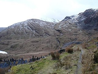
Pen-y-Gwryd is a pass at the head of Nantygwryd and Nant Cynnyd rivers close to the foot of Snowdon in Gwynedd, Wales. The area is located at the junction of the A4086 from Capel Curig to Llanberis and Caernarfon and the A498 from Beddgelert and Nant Gwynant about a mile from the head of the Llanberis Pass. It is close to the boundary with Conwy county borough in northern Snowdonia. The famous mountaineering hostelry, Pen-y-Gwryd Hotel, is located in the pass. It is also a mountain rescue post with links to the other rescue posts at Ogwen Cottage and Plas y Brenin.

Foel-fras is a mountain in the Carneddau range, about 10 km east of Bethesda in North Wales. It lies on the border between the counties of Gwynedd and Conwy. With a summit elevation of 944 metres, it is officially the eleventh-highest summit in Wales. Foel-fras is located at the northern end of the main ridge of the Carneddau, between Drum to the north and Foel Grach to the south with the subsidiary summit of Garnedd Uchaf between it and Foel Grach. Due south and 400 m below lies the reservoir of Llyn Dulyn, while the smaller reservoir of Llyn Anafon lies to the north.

The Llanberis Pass in Snowdonia carries the main road (A4086) from the south-east to Llanberis, over Pen-y-Pass, between the mountain ranges of the Glyderau and the Snowdon massif. At the bottom of the pass is the small village of Nant Peris.

Sychnant Pass in Conwy County Borough, Wales, links Conwy to Penmaenmawr via Dwygyfylchi. Much of the pass is in Snowdonia National Park, and a large area of land within it has been designated a Site of Special Scientific Interest. At the bottom is the village of Capelulo, which lends its name to the community of Penmaenmawr.

Caerhun is a scattered rural community, and former civil parish, on the west bank of the River Conwy. It lies to the south of Henryd and the north of Dolgarrog, in Conwy County Borough, Wales, and includes several small villages and hamlets including Llanbedr-y-cennin, Rowen, Tal-y-bont and Ty'n-y-groes. It was formerly in the historic county of Caernarvonshire. At the 2001 census, it had a population of 1,200, increasing to 1,292 at the 2011 census. It includes a large part of the Carneddau range including the lakes of Llyn Eigiau, Llyn Dulyn and Llyn Melynllyn.
Afon Ddu is the name of several rivers in Snowdonia in north-west Wales:

Rowen is a village on the western slopes of the Conwy valley in the parish of Caerhun and the former County of Caernarfonshire in Wales. It lies off the B5106 road, between Tal y Bont and the Groes Inn. Buildings of Gwynedd 2009 refers to the River Roe probably following the Roman route from Caerhun to Abergwyngregyn. Rowen has won tidiest village awards several times.

Llangelynnin is a former parish in the Conwy valley, in Conwy county borough, north Wales. Today the name exists only in connection with the church, a school in the nearby village of Henryd, and the nearby mountain ridge, Craig Celynnin.

Tal y Fan is an outlying peak of the Carneddau mountains in North Wales. It is one of the four Marilyns that make up the Carneddau, the others being Carnedd Llywelyn, Pen Llithrig y Wrach and Creigiau Gleision.

The Afon Roe is a small river in Snowdonia in north-west Wales.

The B4329 is a scenic route and a former turnpike in Pembrokeshire, West Wales. It links Eglwyswrw in the north of the county to Haverfordwest, the county town in the south, in an approximately southwesterly direction, crossing the Preseli Mountains. It links to the A487 trunk road at both its northern and southern ends.
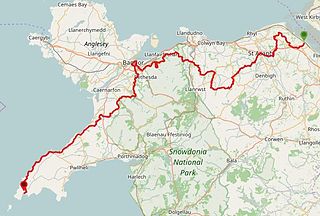
The North Wales Pilgrim's Way is a long-distance walking route in North Wales, running from near Holywell in the east to Bardsey Island in the west. The first half of the trail takes an inland route, with the second half following the north coast of the Llŷn Peninsula. It measures 133.9 miles (215 km) in length, and was officially launched at Porth y Swnt, Aberdaron on 10 July 2014.
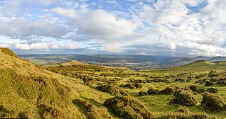
Caer Bach is a Welsh hillfort of indeterminate age, on a rounded hillock situated near the village of Rowen in Conwy County Borough, North Wales. Its name in English translates as 'Small Fort'; or alternatively 'Little Fortress'. It is situated on the Eastern slopes of Tal-y-Fan, an outlying peak of the Carneddau mountain range in northeast Snowdonia; at an altitude of approximately 413 metres. Little information is known about the history of the fort, as to date, the site has undergone minimal investigation. The fort is classed as a scheduled ancient monument and is of national importance for its potential to enhance our knowledge of prehistoric settlement. It is said to retain significant archaeological potential, with a strong probability of the presence of associated archaeological features and deposits.

