Cefn Cyfarwydd

Last updated

The trig point on Cefn Cyfarwydd, above Trefriw. Cefn Cyfarwydd O.S. triangulation pillar - geograph.org.uk - 197099.jpg
The trig point on Cefn Cyfarwydd, above Trefriw.
View WSW along the ridge from the trig point, showing Creigiau Gleision (left) and Pen Llithrig y Wrach (right). Cefn Cyfarwydd Moorland with a View - geograph.org.uk - 223648.jpg
View WSW along the ridge from the trig point, showing Creigiau Gleision (left) and Pen Llithrig y Wrach (right).
Looking along the ridge towards Pen y Graig Gron and Creigiau Gleision. The presence of a style is not necessarily an indication of a good path! Cefn Cyfarwydd style.jpg
Looking along the ridge towards Pen y Graig Gron and Creigiau Gleision. The presence of a style is not necessarily an indication of a good path!
Looking SE - Llyn Cowlyd dam, with Cefn Cyfarwydd behind. Llyn Cowlyd & Cefn Cyfarwydd.jpg
Looking SE - Llyn Cowlyd dam, with Cefn Cyfarwydd behind.
Moorland near Pen y Graig Gron, above the tree-line of the forested slopes. Footpath through Heather Moorland - geograph.org.uk - 213808.jpg
Moorland near Pen y Graig Gron, above the tree-line of the forested slopes.
Pools on the moorland near Pen y Graig Gron. Dried out pools on Pen y Graig Gron - geograph.org.uk - 210803.jpg
Pools on the moorland near Pen y Graig Gron.
A re-arranged cairn on Cefn Cyfarwydd. Cairn on Cefn Cyfarwydd - geograph.org.uk - 210814.jpg
A re-arranged cairn on Cefn Cyfarwydd.

Cefn Cyfarwydd is a ridge in Conwy county borough, north Wales. It is located above the village of Trefriw on the western side of the Conwy valley, and dramatically separates Cwm Cowlyd and the rugged mountains of the Carneddau from the greener, lusher Conwy valley.

Contents

The Welsh word cyfarwydd can mean either "familiar" (adj.) or "a story-teller, guide or expert" (noun). Cefn means "ridge".
'Cefn Cyfarwydd' therefore translates as either "familiar ridge" or "story-teller's ridge".

Extent

The ridge reaches some 500m in height, and covers an area of some 8 square kilometres, broadly 4 km long by 2 km wide. It runs in a largely SW - NE direction, and is relatively flat-topped, resulting in some wet pools and boggy patches, even in the summer months. Much of it is heathery moorland.

To the north-west it slopes down steeply to Llyn Cowlyd, and to the south-east to Llyn Crafnant and the Crafnant valley where, in places, these slopes have been forested. The south-eastern slope of the ridge is steeper than the north-western slope.

The north-eastern end of the ridge drops into the Conwy valley between Trefriw and Dolgarrog, whilst to the south-west it runs on to become Pen y Graig Gron ("top/end of the round stone"), then rises to the ridge of Creigiau Gleision ("blue-green rocks") (over 600m in height) and the Crimpiau. For much of its length it affords splendid views in all directions.

Height

There is a trig point (triangulation pillar TP2074) recording a height of 419 m (1375 ft) at location SH7641664273. [1] This can be easily viewed from Ffordd Cowlyd, the lane from Trefriw to Llyn Cowlyd, which crosses Cefn Cyfarwydd towards its northern end.

The trig point is, however, not at the highest point of the ridge. The highest point actually lies some mile to the south-west, where a cairn has been placed at a height of 503 m (1650 ft). [2] This is just a little north of the remains of Lledwigan burial cairn, which probably dates to the Bronze Age. [3]

Access

The top of the ridge is remote and wild, in direct contrast to the Conwy valley to the east. Whilst remote, it can be accessed by a number of rights of way -

Whilst it is possible to traverse the entire length of the ridge, the north-eastern half is lacking in good paths through the heather, gorse and bilberry, and boggy patches abound. Sheep tracks criss-cross in all directions, and some are used by farmers' quad bikes which makes them the best option, but they are hard to find, even in good conditions. It is easier to find a good path when traversing from south to north (i.e. towards the Trefriw road), as paths can be seen when looking down from above.

Old settlement

The ridge contains the evidence of many remains of old settlement. The Royal Commission on the Ancient and Historical Monuments of Wales reports that a survey in 1993-4 added around 600 sites to the 2 already recorded on the Sites and Monuments Record. According to this record, [5] the earliest evidence of activity was 4 cairns, probably dating back to the Bronze Age, and there was a round hut with adjoining sub-rectangular structures suggesting late prehistoric settlement. Many remains indicated mediaeval occupation, but these were not on the exposed top of the ridge, but generally between the 250m and 350m contours, where the soil was better and there was more shelter.

Most of the later sites have agricultural connections, and in some places traces of earlier field patterns survive. The most substantial remains today are derelict farmhouses, and even two derelict chapels.

It is possible that some of the buildings on the edges of the marginal land may be hafotai (summer dwellings) rather than permanent dwellings.

Industry

The ridge also shows evidence of peat cutting, and there are the remains of several mine trials and small-scale quarrying, such as what is known today as Cefn Cyfarwydd slate mine.

Changing view

The view from Cefn Cyfarwydd has always changed, from the construction of Cowlyd Dam, to the pylons which have appeared further down the Conwy Valley, and as the town of Llanrwst has grown. The 21st century has seen the development of 12 turbines at the Moel Maelogan wind farm on the other side of the Conwy Valley, and very visible from this ridge.

Related Research Articles

<span class="mw-page-title-main">Snowdonia</span> Mountainous region in north Wales

Snowdonia is a mountainous region in northwestern Wales and a national park of 823 square miles (2,130 km2) in area. It was the first to be designated of the three national parks in Wales, in 1951.

<span class="mw-page-title-main">Trefriw</span> Human settlement in Wales

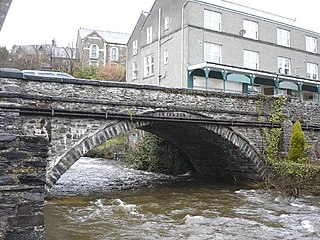
Trefriw is a village and community in Conwy County Borough, Wales. It lies on the river Crafnant in North Wales, a few miles south of the site of the Roman fort of Canovium, sited at Caerhun. At the last three censuses the population of the community has been recorded as 842 in 1999, 915 in 2001, and 783 in 2011.

<span class="mw-page-title-main">River Conwy</span> River in north Wales

The River Conwy is a river in north Wales. From its source to its discharge in Conwy Bay it is 55 kilometres (34 mi) long and drains an area of 678 square km. "Conwy" was formerly anglicised as "Conway."

<span class="mw-page-title-main">Moel Siabod</span> Mountain in Snowdonia, Wales

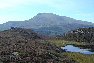
Moel Siabod, is a mountain in Snowdonia, North Wales, which sits isolated above the village of Dolwyddelan. At 872 metres (2,861 ft), it is the highest peak in the Moelwynion mountain range. The UK National Mountain Centre, Plas-y-Brenin, is located at the foot of Moel Siabod. From the top of the mountain, it is reputedly possible to see 13 of the 14 highest peaks in Wales on a clear day without turning one's head.

<span class="mw-page-title-main">Pen Llithrig y Wrach</span> Mountain in Conwy County Borough, Wales

Pen Llithrig y Wrach is a mountain peak in Snowdonia, North Wales. It is one of the four Marilyns that make up the Carneddau range. To the east is Creigiau Gleision, another Marilyn, while to the west is Pen yr Helgi Du and Carnedd Llewelyn. Craig Eigiau and Llyn Eigiau can be seen to the north, while Gallt yr Ogof, Glyder Fach and Tryfan can be viewed to the south.

<span class="mw-page-title-main">Betws-y-Coed railway station</span> Railway station in Conwy, Wales

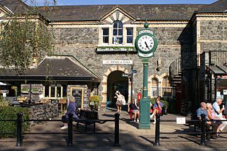
Betws-y-Coed railway station is a railway station on the Conwy Valley Line from Llandudno Junction to Blaenau Ffestiniog, Wales. It is situated 15+12 miles (24.9 km) south of Llandudno Junction.

<span class="mw-page-title-main">Llanrhychwyn</span> Hamlet in Wales

Llanrhychwyn is a hamlet in Conwy county borough, Wales. It lies in the Conwy valley, less than a mile south of Trefriw, and a mile north-west of Llanrwst. Today neighbouring Trefriw is a village with a population of around 600, but in the time of Llywelyn Fawr, and up to the early 19th century, Llanrhychwyn was larger than Trefriw, which consisted simply of "a few houses here and there". Indeed, even today both Trefriw and Llanrhychwyn lie within the parish of Llanrhychwyn. The area around Llanrhychwyn had a population of only 178 in 2011.

<span class="mw-page-title-main">Llyn Cowlyd</span> Body of water

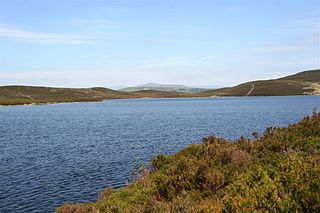
Llyn Cowlyd is the deepest lake in northern Wales. It lies in the Snowdonia National Park at the upper end of Cwm Cowlyd on the south-eastern edge of the Carneddau range of mountains, at a height of 1,164 feet (355 m) above sea level. The lake is long and narrow, measuring nearly 2 miles (3 km) long and about a third of a mile wide, and covers an area of 269 acres (1.1 km2). It has a mean depth of 109 feet (33 m) and at its deepest has given soundings of 229 feet (70 m), this being some 45 ft (14 m) greater than its natural depth, the water surface having been raised twice by the building of dams.

<span class="mw-page-title-main">Llyn Crafnant</span> Body of water

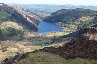
Llyn Crafnant is a lake that lies in a valley in Wales where the northern edge of the Gwydir Forest meets the lower slopes of the Carneddau mountains and, more specifically, the ridge of Cefn Cyfarwydd. The head of the valley offers a profile of crags which are silhouetted at sunset. The Forest Park guide (2002) states that "the is one of the most breathtaking views in all Snowdonia". The summits include Crimpiau 475 metres, and Craig Wen 548 metres which provide views to Moel Siabod and the Ogwen Valley, and Snowdon. Further up is Creigiau Gleision. At 63 acres (250,000 m2) it is the best part of a mile long, although it was clearly once much longer - its southern end shows the evidence of centuries of silting. Jehu's survey (see references) recorded a maximum depth of 71 ft (22 m).

<span class="mw-page-title-main">Llyn Geirionydd</span> Body of water

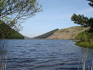
Llyn Geirionydd lies in a valley in North Wales where the northern edge of the Gwydyr Forest meets the lower slopes of the Carneddau mountains. The lake is almost a mile long and covers an area of 45 acres (180,000 m2), but is never any deeper than 50 ft (15 m) according to Jehu's survey. The lake can be reached by car from Trefriw or Llanrwst in the Conwy valley, the lane passing through the hamlet of Llanrhychwyn, or from the road through the Gwydir Forest. Access is not particularly easy by either route, but this has not stopped the lake being the only one designated in Snowdonia to permit power boats and water skiing. Many visitors also walk to the lake from the village of Trefriw or from the neighbouring lake of Llyn Crafnant, which runs parallel to it, but a mile distant, the two being separated by Mynydd Deulyn, “mountain of the two lakes”.

<span class="mw-page-title-main">Afon Crafnant</span> Tributary of the River Conwy , which is the main river of the Conwy valley in north-west Wales

The Afon Crafnant is a tributary of the River Conwy, which is the main river of the Conwy valley in north-west Wales.

<span class="mw-page-title-main">River Geirionydd</span> River in Wales

The River Geirionydd is a river in Snowdonia, North Wales. It is a tributary of the River Crafnant, which flows over the Fairy Falls waterfall in Trefriw, and thence on into the River Conwy, which is the main river of the Conwy valley.

<span class="mw-page-title-main">Llyn Conwy</span> Welsh lake near Cwm Penmachno in central Snowdonia

Llyn Conwy (SH780462) is a lake in the county of Conwy in central north Wales. It is the source of the River Conwy which, on flowing south out of the lake, swings round to then generally flow in a northerly direction for a distance of some 27 miles (43 km) to its discharge in Conwy Bay. Llyn Conwy lies at a height of about 1,488 ft, with a maximum depth of 16 feet, and is by far the biggest lake of the Migneint moors, an extensive area of blanket mire with high rainfall - about 260 cm p.a. There is a view of Arenig Fawr.

<span class="mw-page-title-main">Ffynnon Llugwy</span> Body of water

Ffynnon Llugwy is a lake in the Carneddau range of mountains in Snowdonia, North Wales.

<span class="mw-page-title-main">Tal y Fan</span>

Tal y Fan is an outlying peak of the Carneddau mountains in North Wales. It is one of the four Marilyns that make up the Carneddau, the others being Carnedd Llywelyn, Pen Llithrig y Wrach and Creigiau Gleision.

Eigiau Tramway

The Eigiau Tramway might refer to the Eigiau Quarry Tramway or to the Eigiau Reservoir Tramway.

<span class="mw-page-title-main">Cowlyd Tramway</span>

The Cowlyd Tramway was a 2 ft narrow gauge railway line used to convey men and materials to Llyn Cowlyd Reservoir, near Trefriw in North Wales during the enlargement of the dam, and thereafter for maintenance purposes.

<span class="mw-page-title-main">Creigiau Gleision</span>

Creigiau Gleision is a mountain in Snowdonia, Wales, near Capel Curig. It is the easternmost of the high Carneddau and is separated from the others by Llyn Cowlyd. Directly across this reservoir from Creigiau Gleision is Pen Llithrig y Wrach. To the north-east it runs into the broad ridge of Cefn Cyfarwydd.

<span class="mw-page-title-main">Fairy Falls, Trefriw</span>

The Fairy Falls is a waterfall in the village of Trefriw, north Wales. The falls are on the river Crafnant which has its source at Llyn Crafnant, being joined upstream by a tributary, the river Geirionydd. Below the falls the river Crafnant flows on to itself become a tributary of the river Conwy.

<span class="mw-page-title-main">Klondyke mill</span> Former ore processing mill in Wales

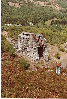
Klondyke Mill was an ore processing mill on the edge of the Gwydir Forest, near Trefriw, north Wales.

References

Coordinates: 53°08′51″N3°52′22″W / 53.1474°N 3.8729°W / 53.1474; -3.8729