
Snowdonia, or Eryri, is a mountainous region and national park in North Wales. It contains all 15 mountains in Wales over 3000 feet high, including the country's highest, Snowdon, which is 1,085 metres (3,560 ft) tall. These peaks are all part of the Snowdon, Glyderau, and Carneddau ranges in the north of the region. The shorter Moelwynion and Moel Hebog ranges lie immediately to the south.

Bala Lake is a large freshwater glacial lake in Gwynedd, Wales. The River Dee, which has its source on the slopes of Dduallt in the mountains of Snowdonia, feeds the 3.7 miles (6.0 km) long by 0.5 miles (0.8 km) wide lake. It was the largest natural body of water in Wales even before its level was raised by Thomas Telford to provide water for the Ellesmere Canal.

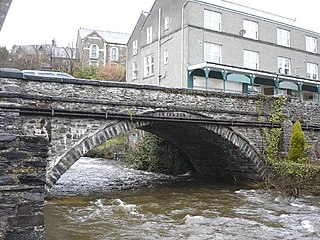
Trefriw is a village and community in Conwy County Borough, Wales. It lies on the river Crafnant a few miles south of the site of the Roman fort of Canovium, sited at Caerhun. At the last three censuses, the population of the community has been recorded as 842 in 1999, 915 in 2001, and 783 in 2011.

A reservoir is an enlarged lake behind a dam, usually built to store fresh water, often doubling for hydroelectric power generation.

The Clywedog Reservoir is a reservoir near Llanidloes, Wales on the head-waters of the River Severn. The construction of the reservoir was enabled by an act of Parliament, the Clywedog Reservoir Joint Authority Act 1963, which asserted that "At certain times the flow of water in the river is inadequate ... unless that flow were regulated so as to ensure that at those times water in addition to the natural flow will flow down the river."
Gwydir Forest, also spelled Gwydyr, is located in Conwy county borough and the Snowdonia National Park in Wales. It takes its name from the ancient Gwydir Estate, established by the John Wynn family of Gwydir Castle, which owned this area.

Llanrhychwyn is a hamlet in Conwy county borough, Wales. It lies in the Conwy valley, less than a mile south of Trefriw, and a mile north-west of Llanrwst. Today neighbouring Trefriw is a village with a population of around 600, but in the time of Llywelyn Fawr, and up to the early 19th century, Llanrhychwyn was larger than Trefriw, which consisted simply of "a few houses here and there". Indeed, even today both Trefriw and Llanrhychwyn lie within the parish of Llanrhychwyn. The area around Llanrhychwyn had a population of only 178 in 2011.

Llyn Cowlyd is the deepest lake in northern Wales. It lies in the Snowdonia National Park at the upper end of Cwm Cowlyd on the south-eastern edge of the Carneddau range of mountains, at a height of 330 metres (1,083 ft) above sea level. The lake is long and narrow, measuring nearly 3 kilometres (2 mi) long and about 500 m wide, and covers an area of 1.1 square kilometres. It has a mean depth of 33 metres (108 ft) and at its deepest has given soundings of 70 metres (230 ft), this being some 14 m (46 ft) greater than its natural depth, the water surface having been raised twice by the building of dams.
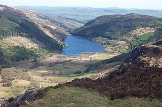
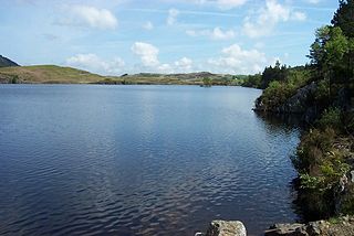
Llyn Crafnant is a lake that lies in a valley in Wales where the northern edge of the Gwydir Forest meets the lower slopes of the Carneddau mountains and, more specifically, the ridge of Cefn Cyfarwydd. The head of the valley offers a profile of crags which are silhouetted at sunset. The Forest Park guide (2002) states that "the is one of the most breathtaking views in all Snowdonia". The summits include Crimpiau 475 metres, and Craig Wen 548 metres which provide views to Moel Siabod and the Ogwen Valley, and Snowdon. Further up is Creigiau Gleision. At 63 acres (250,000 m2) it is the best part of a mile long, although it was clearly once much longer - its southern end shows the evidence of centuries of silting. Jehu's survey (see references) recorded a maximum depth of 71 ft (22 m).

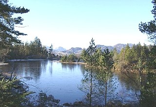
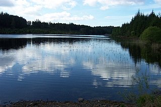
Llyn Geirionydd lies in a valley in North Wales where the northern edge of the Gwydyr Forest meets the lower slopes of the Carneddau mountains. The lake is almost a mile long and covers an area of 45 acres (180,000 m2), but is never any deeper than 50 ft (15 m) according to Jehu's survey. The lake can be reached by car from Trefriw or Llanrwst in the Conwy valley, the lane passing through the hamlet of Llanrhychwyn, or from the road through the Gwydir Forest. Access is not particularly easy by either route, but this has not stopped the lake being the only one designated in Snowdonia to permit power boats and water skiing. Many visitors also walk to the lake from the village of Trefriw or from the neighbouring lake of Llyn Crafnant, which runs parallel to it, but a mile distant, the two being separated by Mynydd Deulyn, “mountain of the two lakes”.
The Afon Crafnant is a tributary of the River Conwy, which is the main river of the Conwy valley in north-west Wales.
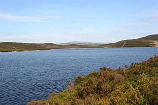
Llyn Conwy (SH780462) is a lake in the county of Conwy in central north Wales. It is the source of the River Conwy which, on flowing south out of the lake, swings round to then generally flow in a northerly direction for a distance of some 27 miles (43 km) to its discharge in Conwy Bay. Llyn Conwy lies at a height of about 1,488 ft, with a maximum depth of 16 feet, and is by far the biggest lake of the Migneint moors, an extensive area of blanket mire with high rainfall - about 260 cm p.a. There is a view of Arenig Fawr.
Llyn Bodgynydd is a lake in the Gwydir Forest in North Wales. It covers an area of some 14 acres (57,000 m2), and lies at a height of 822 feet (251 m) a.s.l.

Llyn Glangors is a lake in the Gwydir Forest in north Wales. It lies at a height of 900 ft (270 m) and covers an area of 15 acres (61,000 m2). An artificial reservoir, it was created to supply water for the nearby Pandora lead mine.
Llyn Goddionduon is a remote lake in the Gwydir Forest in north Wales. It lies at a height of 794 ft (242 m) and covers an area of 10 acres (40,000 m2). It is totally surrounded by coniferous forest, although a track leads up to it, enabling a water supply in the event of fire, and anglers also use this path.

The Grey Mare's Tail is a waterfall on the very edge of the Snowdonia National Park near Gwydir Castle in Conwy County Borough, north Wales. It lies just off the B5106 road between the town of Llanrwst and the large village of Trefriw. The Welsh name, Rhaeadr y Parc Mawr, derives from the fact that the falls are fed by a large stream that has its source in the Gwydir Forest, and flows through the old Parc Mine, about a mile to the southeast. The name 'Grey Mare's Tail' was given to it by Lady Willoughby of Gwydir Castle, possibly "in compliment to Lord Byron and the Staubbach"
Esclusham Mountain is an area in Wrexham County Borough, Wales, United Kingdom, and is part of the Ruabon Moors. It rises to a height of 460 m, with the nearby spur of Cyrn-y-Brain, to the west, reaching 473 m. It lies mostly within the community of Esclusham. A smaller spur to the north, known as Minera Mountain, is within the neighbouring community of Minera.

Klondyke Mill was an ore processing mill on the edge of the Gwydir Forest, near Trefriw, north Wales.

Trefeurig is a community in Ceredigion, Wales, situated around 4 miles (6.4 km) north-east of Aberystwyth. It is a site of particular prehistoric, Roman, and Iron Age interest, and has a long history as a mining area. In 2011 the local population was estimated at 1,771 people.


