Head of the valley

Last updated
The head of the Habachtal valley in the High Tauern in Austria Habachtal Talschluss 2016.jpg
The head of the Habachtal valley in the High Tauern in Austria

The head of the valley or, less commonly, the valley head, refers to the uppermost part of a valley. [1]

Valley Low area between hills, often with a river running through it.

A valley is a low area between hills or mountains typically with a river running through it. In geology, a valley or dale is a depression that is longer than it is wide. The terms U-shaped and V-shaped are descriptive terms of geography to characterize the form of valleys. Most valleys belong to one of these two main types or a mixture of them, at least with respect to the cross section of the slopes or hillsides.

Contents

Description

The head of a valley may take widely differing forms; [1] for example, in highland regions the valley often ends in a broad, evenly sloping hollow. The higher the head of the valley, the more likely it is to resemble the geomorphological shape of a cirque. In glacial valleys or trough valleys, it may be referred to as the trough head or trough end. [2]

Highlands or uplands are any mountainous region or elevated mountainous plateau. Generally speaking, upland refers to ranges of hills, typically up to 500–600 m. Highland is usually reserved for ranges of low mountains.

Cirque An amphitheatre-like valley formed by glacial erosion

A cirque is an amphitheatre-like valley formed by glacial erosion. Alternative names for this landform are corrie and cwm. A cirque may also be a similarly shaped landform arising from fluvial erosion.

In mountains with predominantly crystalline rock the heads of the valleys are generally very wet, sometimes boggy and often support lush alpine meadows, whilst those made of limestone are usually dry and covered in talus or gravel. Where there has been ice age glaciation, the valley bottoms are modified by moraines and mountain lakes are common.

Bog wetland that accumulates peat due to incomplete decomposition of plant leftovers

A bog or bogland is a wetland that accumulates peat, a deposit of dead plant material—often mosses, and in a majority of cases, sphagnum moss. It is one of the four main types of wetlands. Other names for bogs include mire, quagmire, and muskeg; alkaline mires are called fens. They are frequently covered in ericaceous shrubs rooted in the sphagnum moss and peat. The gradual accumulation of decayed plant material in a bog functions as a carbon sink.

Limestone Sedimentary rocks made of calcium carbonate

Limestone is a carbonate sedimentary rock that is often composed of the skeletal fragments of marine organisms such as coral, foraminifera, and molluscs. Its major materials are the minerals calcite and aragonite, which are different crystal forms of calcium carbonate (CaCO3). A closely related rock is dolostone, which contains a high percentage of the mineral dolomite, CaMg(CO3)2. In fact, in old USGS publications, dolostone was referred to as magnesian limestone, a term now reserved for magnesium-deficient dolostones or magnesium-rich limestones.

Scree Broken rock fragments at the base of steep rock faces, that has accumulated through periodic rockfall

Scree is a collection of broken rock fragments at the base of crags, mountain cliffs, volcanoes or valley shoulders that has accumulated through periodic rockfall from adjacent cliff faces. Landforms associated with these materials are often called talus deposits. Talus deposits typically have a concave upwards form, while the maximum inclination corresponds to the angle of repose of the mean debris size.

See also

Structural basin geological depression

A structural basin is a large-scale structural formation of rock strata formed by tectonic warping of previously flat-lying strata. Structural basins are geological depressions, and are the inverse of domes. Some elongated structural basins are also known as synclines. Structural basins may also be sedimentary basins, which are aggregations of sediment that filled up a depression or accumulated in an area; however, many structural basins were formed by tectonic events long after the sedimentary layers were deposited.

U-shaped valley Valleys formed by glacial scouring

U-shaped valleys, trough valleys or glacial troughs, are formed by the process of glaciation. They are characteristic of mountain glaciation in particular. They have a characteristic U shape, with steep, straight sides and a flat or rounded bottom. Glaciated valleys are formed when a glacier travels across and down a slope, carving the valley by the action of scouring. When the ice recedes or thaws, the valley remains, often littered with small boulders that were transported within the ice, called glacial till or glacial erratic.

Landform A natural feature of the solid surface of the Earth or other planetary body

A landform is a natural feature of the solid surface of the Earth or other planetary body. Landforms together make up a given terrain, and their arrangement in the landscape is known as topography. Typical landforms include hills, mountains, plateaus, canyons, and valleys, as well as shoreline features such as bays, peninsulas, and seas, including submerged features such as mid-ocean ridges, volcanoes, and the great ocean basins.

Related Research Articles

Glacier Persistent body of ice that is moving under its own weight

A glacier is a persistent body of dense ice that is constantly moving under its own weight; it forms where the accumulation of snow exceeds its ablation over many years, often centuries. Glaciers slowly deform and flow due to stresses induced by their weight, creating crevasses, seracs, and other distinguishing features. They also abrade rock and debris from their substrate to create landforms such as cirques and moraines. Glaciers form only on land and are distinct from the much thinner sea ice and lake ice that form on the surface of bodies of water.

Death Valley desert valley located in Eastern California

Death Valley is a desert valley located in Eastern California, in the northern Mojave Desert bordering the Great Basin Desert. It is one of the hottest places in the world along with deserts in the Middle East.

Owens Valley

Owens Valley is the now-arid valley of the Owens River in eastern California in the United States, to the east of the Sierra Nevada and west of the White Mountains and Inyo Mountains on the west edge of the Great Basin. The mountain peaks on either side reach above 14,000 feet (4,300 m) in elevation, while the floor of the Owens Valley is about 4,000 feet (1,200 m), making the valley one of the deepest in the United States. The Sierra Nevada casts the valley in a rain shadow, which makes Owens Valley "the Land of Little Rain." The bed of Owens Lake, now a predominantly dry endorheic alkali flat, sits on the southern end of the valley.

Anza-Borrego Desert State Park state park in California

Anza-Borrego Desert State Park (ABDSP) is a California state park located within the Colorado Desert of southern California, United States. The park takes its name from 18th century Spanish explorer Juan Bautista de Anza and borrego, the Spanish word for sheep. With 600,000 acres (240,000 ha) that includes one-fifth of San Diego County, it is the largest state park in California.

Coulee Type of valley or drainage zone

Coulee, or coulée is a term applied rather loosely to different landforms, all of which refer to a kind of valley or drainage zone.

Drainage divide Elevated terrain that separates neighbouring drainage basins

A drainage divide, water divide, divide, ridgeline,, watershed, water parting or height of land is elevated terrain that separates neighbouring drainage basins. On rugged land, the divide lies along topographical ridges, and may be in the form of a single range of hills or mountains, known as a dividing range. On flat terrain, especially where the ground is marshy, the divide may be harder to discern.

Trough (meteorology) elongated region of low atmospheric pressure

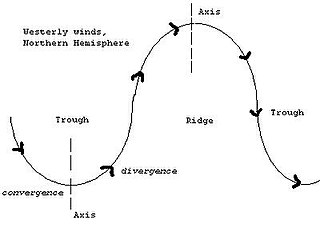
A trough is an elongated (extended) region of relatively low atmospheric pressure, often associated with fronts. Troughs may be at the surface, or aloft, or both under various conditions. Most troughs bring clouds, showers, and a wind shift, particularly following the passage of the trough. This results from convergence or "squeezing" which forces lifting of moist air behind the trough line.

Trough (geology) feature in geology

In geology, a trough is a linear structural depression that extends laterally over a distance. Although it is less steep than a trench, a trough can be a narrow basin or a geologic rift. These features often form at the rim of tectonic plates. There are various oceanic troughs, troughs found under oceans; examples include:

Cedar Mountain Wilderness

The Cedar Mountain Wilderness is located in northwestern Utah, United States, just south of Interstate 80. The vegetation on the upper elevations of the Cedar Mountains is dominated by junipers. The foothill and valley regions include mixed desert shrubs. Cheatgrass is prevalent over large areas burned by range fires. The remains of an aragonite mining camp can also be found in the foothills.

Trough of Bowland mountain pass

The Trough of Bowland is a valley and high pass in the Forest of Bowland Area of Outstanding Natural Beauty, Lancashire, England.

Gat (landform) A relatively narrow but deep strait that is constantly eroded by currents flowing back and forth, such as tidal currents

A gat is a strait that is constantly eroded by currents flowing back and forth, such as tidal currents. It is usually a relatively narrow but deep, up to 30 m (100 ft) passage between land masses or shallow bars in an area of mudflats. A gat is sometimes a shallower passage on lagoon coasts, including those without any tidal range.

Wash margin

A wash margin or wash fringe is an area of the shore on which material is deposited or washed up. It often runs along the margin of a waterbody and there can be several bands due to variations in water levels. As a result of the richness of nutrients that occur in such wash fringes, ruderal species frequently occur here, that, for example, on the Baltic Sea coast consist of grassleaf orache and sea kale.

The Elsinore Trough is a graben rift valley in Riverside County, southern California. It is created by the Elsinore Fault Zone.

<i>Luch</i> (landform)

The term Luch is German and refers to an area of originally expansive, marshy or boggy lowland in northeast Germany, especially in the state of Brandenburg. Luche are found mainly in Young Drift regions; but they also occur on Old Drift landscapes. According to Leser the term should not be translated.

High valley

A high valley or high-level valley is a valley in the upper third of a mountain range. More loosely it can refer to any mountain valley.

Cirque stairway A stepped succession of glacially eroded rock basins

A cirque stairway or sequence of cirque steps is a stepped succession of glacially eroded rock basins. Their individual formation is that of a cirque.

Truncated upland

A truncated upland, truncated highland or bevelled upland is the heavily eroded remains of a fold mountain range, often from an early period in earth history. The term Rumpfgebirge was first introduced into the literature in 1886 by Ferdinand von Richthofen. The rumps of the former mountain ranges may be found in many lowland regions of the earth's crust and especially outcrop in Central Europe through more recent tectonics. This could result in an uplifted peneplain which is one type of truncated upland.

Valley step

A valley step is a prominent change in the longitudinal slope of a valley, mainly in trough valleys formed by glaciers.

References

  1. 1 2 Leser (2005), p. 935.
  2. Leser (2005), p. 978.

Bibliography

International Standard Book Number Unique numeric book identifier

The International Standard Book Number (ISBN) is a numeric commercial book identifier which is intended to be unique. Publishers purchase ISBNs from an affiliate of the International ISBN Agency.