The eastern end of the High Tauern is formed by the Hafner massif of the Ankogel Group, which includes the easternmost three-thousander peaks in the Alpine chain.
Further parts of the High Tauern south of the main crest of the Alps are (from West to East):
Along 100 kilometres (62mi) of the main chain stretches the High Tauern National Park (Nationalpark Hohe Tauern), to which the Austrian Alpine Club as freeholder and the three states of Carinthia, Salzburg and Tyrol have contributed territory. With an area of about 1,834 square kilometres (708sqmi), it is by far the largest of Austria's seven national parks as well as the largest nature reserve in the Alps.[1] It is divided into a core zone of 1,198 square kilometres (463sqmi) including the Grossglockner and Grossvenediger massifs, with complete prohibition of agricultural use, and a fringe zone of 638 square kilometres (246sqmi) used for forestry and alpine-meadow farming. Five special nature sanctuaries are protected from any human disturbance.
The park was established according to a 1971 declaration signed by the participating states at Heiligenblut, it nevertheless took until 1981, when the first parts around Großglockner and Hochschober in Carinthia were put under protection. The adjacent finally joined in 1992. Tourism has become less harmful to the environment. A particular emphasis is put on the protection and maintenance of traditional ways of life in the Alps.
Peaks
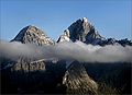
The Großglockner from the southThe Dreiherrnspitze from the west in the year 1890The Hochgall in winter from the westThe Hochalmspitze from the south
The best-known mountain pass road of the High Tauern is the scenic Grossglockner High Alpine Road inaugurated in 1935, including a tunnel at an elevation of 2,505 metres (8,219ft) under the Hochtor Pass (2,573 metres (8,442ft)). East of it, the Katschberg Pass (1,641 metres (5,384ft)) on B 99 Katschberg Straße highway parallel to the Katschberg Tunnel links Sankt Michael and Rennweg. Another road crosses the Staller Sattel between Sankt Jakob in Defereggen and Rasen-Antholz at 2,052 metres (6,732ft).
Beside there are numerous bridle and footpaths, in part used since ancient times:
This page is based on this Wikipedia article Text is available under the CC BY-SA 4.0 license; additional terms may apply. Images, videos and audio are available under their respective licenses.