
The Grossglockner, or just Glockner, is, at 3,798 metres above the Adriatic (12,461 ft), the highest mountain in Austria and the highest mountain in the Alps east of the Brenner Pass. It is part of the larger Glockner Group of the Hohe Tauern range, situated along the main ridge of the Central Eastern Alps and the Alpine divide. The Pasterze, Austria's most extended glacier, lies on the Grossglockner's eastern slope.

The High Tauern are a mountain range on the main chain of the Central Eastern Alps, comprising the highest peaks east of the Brenner Pass. The crest forms the southern border of the Austrian states of Salzburg, Carinthia and East Tyrol, with a small part in the southwest belongs to the Italian province of South Tyrol. The range includes Austria's highest mountain, the Grossglockner at 3,798 metres (12,461 ft) above the Adriatic.

The Radstadt Tauern are a subrange of the Central Eastern Alps in Austria. Together with the Schladming Tauern, the Rottenmann and Wölz Tauern and the Seckau Tauern the Radstadt Tauern form the major range of mountains known as the Low Tauern. The mountains are found in the southeast of the Austrian state of Salzburg, between the upper reaches of the Enns and Mur rivers.
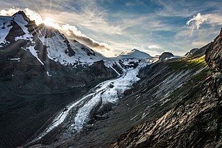
The Pasterze, at approximately 8.4 kilometres (5.2 mi) in length, is the longest glacier in Austria and in the Eastern Alps. It lies within the Glockner Group of the High Tauern mountain range in Carinthia, directly beneath Austria's highest mountain, the Grossglockner.

The Großes Wiesbachhorn is a mountain in the federal state of Salzburg, Austria and, at 3,564 m above sea level (AA), is the third-highest peak of the Hohe Tauern range.

The Schober group is a sub-range of the Hohe Tauern mountains in the Central Eastern Alps, on the border between the Austrian states of Tyrol and Carinthia. Most of the range is located inside Hohe Tauern national park. It is named after Mt. Hochschober, 3,242 metres (10,636 ft), though its highest peak is Mt. Petzeck at 3,283 metres (10,771 ft).
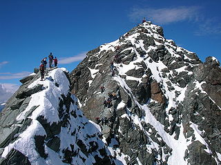
At the height of 3,770 metres (12,370 ft) the Kleinglockner is the third highest mountain summit in Austria. However, with a prominence of only 17 metres it is arguable whether it can be counted as an independent mountain, or just as a subpeak of the Großglockner. It lies in the Glockner Group of Austria's Central Alps, the middle section of the Hohe Tauern. Geographically and geologically speaking, it is viewed a secondary summit of the neighbouring Großglockner, but in the literature, in view of its importance to mountaineering, it is in some cases treated as separate. Its peak forms part of the Glockner crest or ridge (Glocknerkamm) and lies exactly on the border between the Austrian state of Carinthia and Lienz District in the East Tyrol. The Kleinglockner has the shape of a sharp edge, covered with the so-called Glockner Cornice (Glocknerwechte) and, depending on the conditions, can make the ascent of the mountain dangerous to almost impossible. The climbing history of the Kleinglockner is closely linked to that of the Großglockner, because the first climbers, coming from the south and east, had to cross it.

The Granatspitze Group, sometimes also the Granatspitz Group, is a sub-group of the Central Alps within the Eastern Alps. Together with the Ankogel Group, the Goldberg Group, the Glockner Group, the Schober Group, the Kreuzeck Group, the Venediger Group, the Villgraten Mountains and the Rieserferner Group, the Granatspitze Group forms the main range known as the High Tauern. The Granatspitze Group is located in Austria in the federal states of Salzburg and Tyrol. Its highest summit is the Großer Muntanitz, 3,232 m (AA)

The Hohe Dock lies in the Austrian federal state of Salzburg and, at 3,348 metres, is one of the highest peaks in the Glockner Group. The mountain, with its striking trapezoidal shape, dominates the orographically left-hand side of the valley of the Fuscher Ache and the panorama above the northern ramp of the Großglockner High Alpine Road.

The Fuscherkarkopf, sometimes also written Fuscher-Kar-Kopf in German and formerly also called the Fuschereiskarkopf, is one of the twin peaks of a mountain in the Glockner Group in the centre of the main mountain chain in the High Tauern, a range in the Austrian Central Alps. The mountain lies right on the border between the Austrian states of Salzburg and Carinthia. The main peak is 3,331 metres high, but the northwest summit is only 3,252 metres high. The two peaks are about 500 metres apart and linked by a curved firn-covered ridge. Further sharp, prominent ridges run away to the northwest and west, forming the main crest of the Tauern. To the southwest the Heiligenblut Open Face branches off, a mighty side ridge that starts as the southeast ridge (Südostgrat) at the Fuscherkarkopf. The northwest summit has a great, 650-metre-high (2,130 ft) West Face (Westwand), that used to be covered with firn, but today is covered with loose rock slabs. The mountain is easy to reach from the Hofmanns Hut over the southwest ridge (Südwestgrat) and offers a good view of the Großglockner and the Pasterze. The peak was first climbed in the 1840s by the hunter, Gregor Maier, known as Badhans, from Fusch.
The Hinterer Bratschenkopf is a mountain in the Glockner Group on the Fusch-Kaprun ridge in the High Tauern, a high mountain range in the Austrian Central Alps. According to the listed sources it is 3,412 metres high, but the Austrian Federal Office for Metrology and Survey gives its height as 3,413 metres. The mountain lies in the Austrian state of Salzburg. It appears from the north, east and south as a gently curved firn summit, but from the west it has a mighty, 1,400-metre-high (4,600 ft) and 40 to 60° rock face. A steep, 500-metre-long (1,600 ft) knife-edge ridge bears away from the mountaintop to the north. Due to its close proximity to the Heinrich Schwaiger Haus, the summit is a popular viewing point. The peak was first climbed on 18 September 1869 by the Munich Alpinist, Karl Hofmann, the Prague businessman, Johann Stüdl, and mountain guides Thomas Groder and Josef Schnell from Kals am Großglockner.

The Glocknerwand is a mountain in the Glockner Group in the Austrian Central Alps in the central region of the High Tauern. According to the literature it is 3,721 metres high, but the Austria Federal Office for Metrology and Survey gives its height as 3,722 metres. It is separated from Austria's highest peak, the neighbouring Großglockner, by the col known as the Untere Glocknerscharte (3596 m). The mountain lies on the boundary between East Tyrol and Carinthia.

The Goldberg Group is a sub-group of the Hohe Tauern mountain range within the Central Eastern Alps. It is located in Austria, in the states of Salzburg and Carinthia. Its highest peak is the Hocharn, 3,254 m (AA). Other well known summits are the Hoher Sonnblick, with its observatory at 3,106 m above sea level (AA), and the Schareck at 3,123 m above sea level (AA)

The Villgraten Mountains or Deferegg Alps, also called the Defreggen Mountains are a subgroup of the Austrian Central Alps within the Eastern Alps of Europe. Together with the Ankogel Group, the Goldberg Group, the Glockner Group, the Schober Group, the Kreuzeck Group, the Granatspitze Group, the Venediger Group and the Rieserferner Group, the Villgraten Mountains are part of the major mountain range, the High Tauern. Their highest summit is the Weiße Spitze with a height of 2,962 m above sea level (AA).

The Hoher Prijakt and Niederer Prijakt are a prominent double summit which, seen from the west and north, form one of the most attractively-shaped mountains of the Schober Group in the state of Tyrol in western Austria. The summit cross was placed on the lower Niederer Prijakt which is easier to see from the valley.

The Rote Knopf is the second highest mountain in the Schober Group within the High Tauern in the Austrian Alps. It is only two metres short of the Petzeck, the highest summit in the Schober. Nevertheless, this peak is far less well known that the Hochschober or the Glödis. This is probably because the mountain is not visible from the valleys of the Kalser Tal or the anterior Debanttal.

The Große Bärenkopf or Weißer Bärenkopf is a twin-topped mountain in the Glockner Group in the Fuscher/Kapruner Kamm of the High Tauern, a range in the Austrian Central Alps. The mountain lies exactly on the border between the states of Salzburg and Carinthia.

The Racherin, a mountain with a height of 3,092 m (AA), lies in the Glockner Group in the High Tauern range in Austria. The summit is located ca. 6 km, as the crow flies, northwest of Heiligenblut in the state of Carinthia. The unmarked and mostly trackless normal route is not difficult in snow-free and dry conditions, but is rather laborious. An ascent therefore requires a good sense of direction. In suitable weather there are good views from the top, including an impressive view of the Großglockner and the surrounding mountain world.

The Klockerin, formerly also called the Glockerin or Glocknerin, is a twin-peaked mountain in the Glockner Group on the ridge of Fuscher/Kapruner Kamm in the High Tauern, a range within the Central Alps in the Austrian state of Salzburg. Its southwest top (Südwestgipfel) is 3,422 m (AA) high, its northeast top (Nordostgipfel) has a height of 3,335 m. The two summits are about 240 metres apart. A prominent arête runs westwards; the west-northwestern arête is a short, but knife-edge ridge of rock. The Klockerin has a mighty Northwest Face which is 920 metres high and has a gradient of 54°. The mountain is geographically dominant compared with the southern and western neighbouring peaks. Especially from the west, where the Mooserboden Reservoir lies, the Klockerin appears as a mighty massif. The mountain was first climbed on 18 September 1869 by German alpinist, Karl Hofmann, Prague merchant, Johann Stüdl and mountain guides, Thomas Groder and Josef Schnell from Kals am Großglockner.

The Wangenitzsee Hut is a mountain hut in Hohe Tauern National Park, in Carinthia, Austria. It is situated directly on the Wangenitzsee, the largest lake of the Schober group of the Eastern Alps. At an altitude of 2,508 metres (8,228 ft) above sea level (AA), it is the highest hut in the Schober group. Depending on the weather, it opens in the middle of June and closes at the end of September. It is located on the Wiener Höhenweg, and is supplied by a material ropeway from the Debanttal.


