
The Grossglockner, or just Glockner, is, at 3,798 metres above the Adriatic (12,461 ft), the highest mountain in Austria and the highest mountain in the Alps east of the Brenner Pass. It is part of the larger Glockner Group of the Hohe Tauern range, situated along the main ridge of the Central Eastern Alps and the Alpine divide. The Pasterze, Austria's most extended glacier, lies on the Grossglockner's eastern slope.

The Großes Wiesbachhorn is a mountain in the federal state of Salzburg, Austria and, at 3,564 m above sea level (AA), is the third-highest peak of the Hohe Tauern range.

The Dreiherrnspitze, at 3,499 m (11,480 ft) above mean sea level, is a mountain on the tripoint between the Austrian states of Salzburg and Tyrol, and South Tyrol in Italy. It is part of the Venediger Group in the Hohe Tauern range of the Central Eastern Alps and the Alpine divide.

The Glockner Group is a sub-group of the Austrian Central Alps in the Eastern Alps, and is located in the centre section of the High Tauern on the main chain of the Alps.
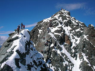
At the height of 3,770 metres (12,370 ft) the Kleinglockner is the third highest mountain summit in Austria. However, with a prominence of only 17 metres it is arguable whether it can be counted as an independent mountain, or just as a subpeak of the Großglockner. It lies in the Glockner Group of Austria's Central Alps, the middle section of the Hohe Tauern. Geographically and geologically speaking, it is viewed a secondary summit of the neighbouring Großglockner, but in the literature, in view of its importance to mountaineering, it is in some cases treated as separate. Its peak forms part of the Glockner crest or ridge (Glocknerkamm) and lies exactly on the border between the Austrian state of Carinthia and Lienz District in the East Tyrol. The Kleinglockner has the shape of a sharp edge, covered with the so-called Glockner Cornice (Glocknerwechte) and, depending on the conditions, can make the ascent of the mountain dangerous to almost impossible. The climbing history of the Kleinglockner is closely linked to that of the Großglockner, because the first climbers, coming from the south and east, had to cross it.
The Eiskögele is a 3,426-metre-high (11,240 ft) mountain in the Glockner Group in the western part of the main Tauern chain, a range of the Austrian Central Alps. It lies right on the border between the Austrian states of Salzburg, Carinthia and East Tyrol and thus forms a tripoint. The mountain has the shape of an ice-covered horn with a mighty North Face, a prominent Northeast Ridge (Nordostgrat) and a sharp firn edge (Firnschneide) to the west. From its base, the Oberwalder Hut, it is easy to reach via the Pasterzeboden glacier. It was first climbed on 30 July 1872 by the tourist B. Lergetporer from Schwaz and mountain guides, Michel Groder and Josef Kerer. The first solo ascent of the mountain was achieved in August 1891 by Ludwig Kohn from Vienna as part of a crossing from the Schneewinkelkopf.
The Hinterer Bratschenkopf is a mountain in the Glockner Group on the Fusch-Kaprun ridge in the High Tauern, a high mountain range in the Austrian Central Alps. According to the listed sources it is 3,412 metres high, but the Austrian Federal Office for Metrology and Survey gives its height as 3,413 metres. The mountain lies in the Austrian state of Salzburg. It appears from the north, east and south as a gently curved firn summit, but from the west it has a mighty, 1,400-metre-high (4,600 ft) and 40 to 60° rock face. A steep, 500-metre-long (1,600 ft) knife-edge ridge bears away from the mountaintop to the north. Due to its close proximity to the Heinrich Schwaiger Haus, the summit is a popular viewing point. The peak was first climbed on 18 September 1869 by the Munich Alpinist, Karl Hofmann, the Prague businessman, Johann Stüdl, and mountain guides Thomas Groder and Josef Schnell from Kals am Großglockner.

The Johannisberg is a 3,453 metres (11,329 ft) high mountain in the Glockner Group of the High Tauern, a mountain range of the Central Eastern Alps in Austria.

The Glocknerwand is a mountain in the Glockner Group in the Austrian Central Alps in the central region of the High Tauern. According to the literature it is 3,721 metres high, but the Austria Federal Office for Metrology and Survey gives its height as 3,722 metres. It is separated from Austria's highest peak, the neighbouring Großglockner, by the col known as the Untere Glocknerscharte (3596 m). The mountain lies on the boundary between East Tyrol and Carinthia.

The Glocknerhorn and Teufelshorn are two nearby mountain peaks in the Glockner Group in the Austrian Central Alps in the central part of the High Tauern. According to the literature, Teufelshorn is 3,677 metres high. The Austrian Federal Office for Metrology and Survey gives Glocknerhorn's elevation as 3,680 metres, but naming it "Teufelshorn" by mistake. Both lie on the Northwest Ridge (Nordwestgrat) of Austria's highest peak, the neighbouring Großglockner, along which the border between the Austrian federal states of Tyrol and Carinthia runs. The lower Teufelshorn in the west has a turret-like summit that juts about 30 metres above the massif itself and, together with the higher and similar-looking Glocknerhorn in the east, forms a twin peak. The Teufelshorn was first climbed on 8 August 1884 by Moriz von Kuffner, guided by Christian Ranggetiner and E. Rubesoier. The 3,680-metre-high (12,070 ft) Glocknerhorn, by contrast, had already been conquered on 29 August 1879 by the Alpinists, Gustav Gröger and Christian Ranggetiner.

The Gefrorene-Wand-Spitzen are two summits on the Tux Crest, a mountain chain in the Zillertal Alps, one of the ranges of the central Eastern Alps in the Austrian state of Tyrol. The north summit (Nordgipfel) is recorded as 3,286 metres high in the literature, but is 3,288 metres high according to the Federal Office for Metrology and Survey. The south summit (Südgipfel), by contrast, is only 3,270 metres high. The two peaks are about 300 metres apart. They appear from the north as a stubby, cone-shaped, firn-covered dome, but from the east as a forbidding, dark rock face. Sharp, prominent ridges radiate from the peaks to the northeast and southwest, along the main crest of the mountain range. The twin peaks are the highest points in the summer skiing area of the Hintertux Glacier and, since the end of the 1990s, have been accessible from Hintertux on cable cars and ski lifts; which makes them a popular destination for day trippers. The north summit was first conquered in 1867 by Dr. Berreitter, the south summit on 7 September 1872 by brothers Max and Richard von Frey from Salzburg.
The Hoher Tenn, formerly also called the Hochtenn, is a double-peaked mountain in the Austrian federal state of Salzburg. It has a southwest summit, called the Bergspitze with a height of 3,368 metres (11,050 ft), and a northeast summit, the Schneespitze, which is 3,317 metres (10,883 ft) high. The Tenn belongs to the Glockner Group in the central part of the High Tauern in the Austrian Central Alps. Between the two summits at a height of 3,293 metres (10,804 ft) is the Tenn Saddle (Tennsattel). Long knife-edge ridges run away to the northeast and northwest. It has a large topographical prominence, especially to the north, which, together with its easy accessibility, make it a popular climbing mountain. Seen from Zell am See in the Pinzgau it is second only to the Imbachhorn in dominating the Tauern panorama.

At 3,474 m (AA) the Ruderhofspitze is the fourth highest mountain in the Stubai Alps in Austria. It is part of the Alpein Mountains and lies in the Austrian state of Tyrol. As a result of its topographic isolation and good all-round views it is one of the most visited mountains in the Stubai. An almost two-kilometre-long arête, the Grawawand, runs away from the summit to the east. Less prominent ridges run south and northwestwards from the Ruderhofspitze. The peak was first ascended on 30 August 1864 by Karl Baedeker, Anton von Ruthner and mountain guides Pankraz Gleinser and Alois Tanzer.

The Große Bärenkopf or Weißer Bärenkopf is a twin-topped mountain in the Glockner Group in the Fuscher/Kapruner Kamm of the High Tauern, a range in the Austrian Central Alps. The mountain lies exactly on the border between the states of Salzburg and Carinthia.
The Großer Geiger, formerly also called the Obersulzbacher Venediger and Heiliggeistkogel, is a mountain, 3,360 m (AA), in the Venediger Group in the main chain of the Central Tauern. This chain lies in the High Tauern, part of the Austrian Central Alps on the border between the Austrian states of Tyrol in the south and Salzburg in the north.

The Schlieferspitze is a mountain, 3,290 m (AA), on the ridge known as the Krimmler Kamm in the Venediger Group of the Alps. The ridge lies in the northwest of the High Tauern, part of the Austrian Central Alps in the Austrian federal state of Salzburg. The summit is the highest on the Krimmler Kamm and is described in the sources as one of the most attractive peaks in the Venediger Group. From the valleys of the Krimmler Achental to the southwest and the Obersulzbachtal to the northeast it appears as an extremely dominant mountain. Long and evenly formed arêtes, about two kilometres long, run from the summit to the northwest, northeast, southeast and southwest. The mountain was first ascended on 22 August 1871 by Eduard Richter, professor of geography at the University of Graz, and Johann Stüdl, a merchant from Prague and co-founder of the German Alpine Club.
The Gleirscher Fernerkogel, also Gleirschfernerkogl, formerly called the Roßkarspitze, is a mountain, 3,189 m (AA), in the Southern Sellrain Mountains, a subgroup of the Stubai Alps. It rises in the Austrian state of Tyrol. The old name, Roßkarspitze, was given to it during the military survey of the region in the 1850s. The first documented ascent was undertaken on 1 September 1883 by Ludwig Purtscheller and Hans Schöller, a "professor from Salzburg". Purtscheller gave the mountain its present name. A prominent 500-metre-long ridge runs eastwards from the unimposing summit.
The Jochköpfl is a mountain, 3,143 m (AA), on the Windach-Brunnenkogel-Kamm, a subgroup of the Stubai Alps in Austria.

The Klockerin, formerly also called the Glockerin or Glocknerin, is a twin-peaked mountain in the Glockner Group on the ridge of Fuscher/Kapruner Kamm in the High Tauern, a range within the Central Alps in the Austrian state of Salzburg. Its southwest top (Südwestgipfel) is 3,422 m (AA) high, its northeast top (Nordostgipfel) has a height of 3,335 m. The two summits are about 240 metres apart. A prominent arête runs westwards; the west-northwestern arête is a short, but knife-edge ridge of rock. The Klockerin has a mighty Northwest Face which is 920 metres high and has a gradient of 54°. The mountain is geographically dominant compared with the southern and western neighbouring peaks. Especially from the west, where the Mooserboden Reservoir lies, the Klockerin appears as a mighty massif. The mountain was first climbed on 18 September 1869 by German alpinist, Karl Hofmann, Prague merchant, Johann Stüdl and mountain guides, Thomas Groder and Josef Schnell from Kals am Großglockner.

