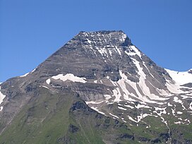
The Grossglockner, or just Glockner, is, at 3,798 metres above the Adriatic (12,461 ft), the highest mountain in Austria and the highest mountain in the Alps east of the Brenner Pass. It is part of the larger Glockner Group of the Hohe Tauern range, situated along the main ridge of the Central Eastern Alps and the Alpine divide. The Pasterze, Austria's most extended glacier, lies on the Grossglockner's eastern slope.

The Kitzbühel Alps are a mountain range of the Central Eastern Alps surrounding the town of Kitzbühel in Tyrol, Austria. Geologically they are part of the western slate zone.

The Stubai Alps is a mountain range in the Central Eastern Alps of Europe. It derives its name from the Stubaital valley to its east and is located southwest of Innsbruck, Austria. Several peaks form the border between Austria and Italy. The range is bounded by the Inn River valley to the north; the Sill River valley (Wipptal) and the Brenner Pass to the east ; the Ötztal and Timmelsjoch to the west, and to the south by tributaries of the Passer River and Eisack.

The High Tauern are a mountain range on the main chain of the Central Eastern Alps, comprising the highest peaks east of the Brenner Pass. The crest forms the southern border of the Austrian states of Salzburg, Carinthia and East Tyrol, with a small part in the southwest belongs to the Italian province of South Tyrol. The range includes Austria's highest mountain, the Grossglockner at 3,798 metres (12,461 ft) above the Adriatic.
A col in geomorphology is the lowest point on a mountain ridge between two peaks. It may also be called a gap or pass. Particularly rugged and forbidding cols in the terrain are usually referred to as notches. They are generally unsuitable as mountain passes, but are occasionally crossed by mule tracks or climbers' routes. Derived from the French col from Latin collum, "neck", the term tends to be associated more with mountain than hill ranges. The distinction with other names for breaks in mountain ridges such as saddle, wind gap or notch is not sharply defined and may vary from place to place. Many double summits are separated by prominent cols.

Turracher Höhe, also called Turracherhöhe, refers to a village, a pass across the Alps, and a countryside in the Gurktal Alps in Austria. The village and the Turracher Lake at the pass, which both share the same name, are separated by the border of the two federal states of Styria and Carinthia. Because of its distance to early settlement areas and its high location, the region was not settled until relatively late. In the 17th century, mining was started below the Turracherhöhe. The opening up of the top of the pass by a paved road did not occur until later. During the 20th century, the region was gradually developed for tourism. Efforts are being made to maintain the diversity of flora and fauna of the Turracherhöhe by means of landscape conservation areas and careful and nature-oriented extension of the tourist facilities.

The Großes Wiesbachhorn is a mountain in the federal state of Salzburg, Austria and, at 3,564 m above sea level (AA), is the third-highest peak of the Hohe Tauern range.

The Allgäu Alps are a mountain range in the Northern Limestone Alps, located on the Austria–Germany border, which covers parts of the German states of Bavaria and Baden-Württemberg and the Austrian states of Tyrol and Vorarlberg. The range lies directly east of Lake Constance.

The Schober group is a sub-range of the Hohe Tauern mountains in the Central Eastern Alps, on the border between the Austrian states of Tyrol and Carinthia. Most of the range is located inside Hohe Tauern national park. It is named after Mt. Hochschober, 3,242 metres (10,636 ft), though its highest peak is Mt. Petzeck at 3,283 metres (10,771 ft).

The Dreiherrnspitze, at 3,499 m (11,480 ft) above mean sea level, is a mountain on the tripoint between the Austrian states of Salzburg and Tyrol, and South Tyrol in Italy. It is part of the Venediger Group in the Hohe Tauern range of the Central Eastern Alps and the Alpine divide.

The Ammergau Alps are a mountain range in the Northern Limestone Alps in the states of Bavaria (Germany) and Tyrol (Austria). They cover an area of about 30 x 30 km and begin at the outer edge of the Alps. The highest summit is the Daniel which has a height of 2,340 metres (7,680 ft).

The Glockner Group is a sub-group of the Austrian Central Alps in the Eastern Alps, and is located in the centre section of the High Tauern on the main chain of the Alps.

The Rax-Schneeberg Group is a mountain range in the Northern Limestone Alps on the Styrian-Lower Austrian border in Austria.
At the height of 3,770 metres (12,370 ft) the Kleinglockner is the third highest mountain summit in Austria. However, with a prominence of only 17 metres it is arguable whether it can be counted as an independent mountain, or just as a subpeak of the Großglockner. It lies in the Glockner Group of Austria's Central Alps, the middle section of the Hohe Tauern. Geographically and geologically speaking, it is viewed a secondary summit of the neighbouring Großglockner, but in the literature, in view of its importance to mountaineering, it is in some cases treated as separate. Its peak forms part of the Glockner crest or ridge (Glocknerkamm) and lies exactly on the border between the Austrian state of Carinthia and Lienz District in the East Tyrol. The Kleinglockner has the shape of a sharp edge, covered with the so-called Glockner Cornice (Glocknerwechte) and, depending on the conditions, can make the ascent of the mountain dangerous to almost impossible. The climbing history of the Kleinglockner is closely linked to that of the Großglockner, because the first climbers, coming from the south and east, had to cross it.

The Granatspitze Group, sometimes also the Granatspitz Group, is a sub-group of the Central Alps within the Eastern Alps. Together with the Ankogel Group, the Goldberg Group, the Glockner Group, the Schober Group, the Kreuzeck Group, the Venediger Group, the Villgraten Mountains and the Rieserferner Group, the Granatspitze Group forms the main range known as the High Tauern. The Granatspitze Group is located in Austria in the federal states of Salzburg and Tyrol. Its highest summit is the Großer Muntanitz, 3,232 m (AA)

The Mieming(er) Range, Mieminger Chain or Mieminger Mountains, is a mountain range of the Northern Limestone Alps in the Eastern Alps. It is located entirely in Austria within the state of Tyrol. This sub-group is somewhat in the shadows of its more famous neighbour, the Wetterstein to the north. Whilst the region around the Coburger Hut and the lakes of Seebensee and Drachensee in the west and the Hohe Munde in the extreme east receive large numbers of visitors, the less developed central area remains very quiet. The Hohe Munde is also a popular and challenging ski touring destination.

The Goldberg Group is a sub-group of the Hohe Tauern mountain range within the Central Eastern Alps. It is located in Austria, in the states of Salzburg and Carinthia. Its highest peak is the Hocharn, 3,254 m (AA). Other well known summits are the Hoher Sonnblick, with its observatory at 3,106 m above sea level (AA), and the Schareck at 3,123 m above sea level (AA)

The Villgraten Mountains or Deferegg Alps, also called the Defreggen Mountains are a subgroup of the Austrian Central Alps within the Eastern Alps of Europe. Together with the Ankogel Group, the Goldberg Group, the Glockner Group, the Schober Group, the Kreuzeck Group, the Granatspitze Group, the Venediger Group and the Rieserferner Group, the Villgraten Mountains are part of the major mountain range, the High Tauern. Their highest summit is the Weiße Spitze with a height of 2,962 m above sea level (AA).

The Große Bärenkopf or Weißer Bärenkopf is a twin-topped mountain in the Glockner Group in the Fuscher/Kapruner Kamm of the High Tauern, a range in the Austrian Central Alps. The mountain lies exactly on the border between the states of Salzburg and Carinthia.

The Kaiser-Franz-Josefs-Höhe is part of the Grossglockner High Alpine Road. The end point of a cul-de-sac and lookout point is in Austria in the Glockner Group in Carinthia at an altitude of 2,369 m (7,772 ft) above sea level. The Kaiser-Franz-Josefs-Höhe can only be reached by vehicle via the Grossglockner High Alpine Road, which is subject to a toll, from both Salzburg and Carinthia.