
Salzburg is an Austrian federal state. In German it is called a Bundesland, a German-to-English dictionary translates that to federal state and the European Commission calls it a province. In German, its official name is Land Salzburg, to distinguish it from its eponymous capital Salzburg. For centuries, it was an independent Prince-Bishopric of the Holy Roman Empire. It borders Germany and Italy.
Ache or Aches may refer to:

The Inn is a river in Switzerland, Austria and Germany. The 518 km (322 mi) long river is a right tributary of the Danube, being the third largest tributary of the Danube by discharge. The highest point of its drainage basin is the summit of Piz Bernina at 4,049 m (13,284 ft). The Engadine, the valley of the En, is the only Swiss valley whose waters end up in the Black Sea.

The Salzach is a river in Austria and Germany. It is 227 kilometres (141 mi) in length and is a right tributary of the Inn, which eventually joins the Danube. Its drainage basin of 6,829 km2 (2,637 sq mi) comprises large parts of the Northern Limestone and Central Eastern Alps. 83% of its drainage basin lies in Austria, the remainder in Germany (Bavaria). Its largest tributaries are Lammer, Berchtesgadener Ache, Saalach, Sur and Götzinger Achen.

The Kitzbühel Alps are a mountain range of the Central Eastern Alps surrounding the town of Kitzbühel in Tyrol, Austria. Geologically they are part of the western slate zone.

Krimml is a municipality in Zell am See District, in the federal state of Salzburg, Austria, in the Pinzgau region.

Fusch an der Großglocknerstraße is a municipality, at the foot of Grossglockner mountain, in the district of Zell am See, in the state of Salzburg in Austria. The Fusch valley lies north of the main chain of the Alps. The population is 697. Fusch has an elevation of 813 metres (2,667 ft), but the maximum elevation within the municipality is 3,564 metres (11,693 ft), rising up Grossglockner mountain.

The Großes Wiesbachhorn is a mountain in the federal state of Salzburg, Austria and, at 3,564 m above sea level (AA), is the third-highest peak of the Hohe Tauern range.

Bruck an der Großglocknerstraße is a municipality in Zell am See District, in the state of Salzburg in Austria.
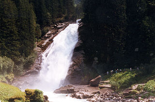
The Krimml Waterfalls, with a total height of 380 metres, are the highest waterfall in Austria. The falls are on the Krimmler Ache river and are located near the village of Krimml in the High Tauern National Park in Salzburg state.

The Lammer is a river of Salzburg, Austria, a right tributary of the Salzach.

The Großache is a river, 79 kilometres (49 mi) long, in the east of the Austrian state of Tyrol and the Bavarian region of Chiemgau.

The Hoher Göll is a 2,522 m (8,274 ft) mountain in the Berchtesgaden Alps. It is the highest peak of the Göll massif, which straddles the border between the German state of Bavaria and the Austrian state of Salzburg.

The Fuscherkarkopf, sometimes also written Fuscher-Kar-Kopf in German and formerly also called the Fuschereiskarkopf, is one of the twin peaks of a mountain in the Glockner Group in the centre of the main mountain chain in the High Tauern, a range in the Austrian Central Alps. The mountain lies right on the border between the Austrian states of Salzburg and Carinthia. The main peak is 3,331 metres high, but the northwest summit is only 3,252 metres high. The two peaks are about 500 metres apart and linked by a curved firn-covered ridge. Further sharp, prominent ridges run away to the northwest and west, forming the main crest of the Tauern. To the southwest the Heiligenblut Open Face branches off, a mighty side ridge that starts as the southeast ridge (Südostgrat) at the Fuscherkarkopf. The northwest summit has a great, 650-metre-high (2,130 ft) West Face (Westwand), that used to be covered with firn, but today is covered with loose rock slabs. The mountain is easy to reach from the Hofmanns Hut over the southwest ridge (Südwestgrat) and offers a good view of the Großglockner and the Pasterze. The peak was first climbed in the 1840s by the hunter, Gregor Maier, known as Badhans, from Fusch.

The Berchtesgadener Ache is a river of Bavaria, Germany and of Salzburg, Austria. It is formed at the confluence of the Ramsauer Ache and the Königsseer Ache in Berchtesgaden. It flows into the Salzach near Anif.

The Goldberg Group is a sub-group of the Hohe Tauern mountain range within the Central Eastern Alps. It is located in Austria, in the states of Salzburg and Carinthia. Its highest peak is the Hocharn, 3,254 m (AA). Other well known summits are the Hoher Sonnblick, with its observatory at 3,106 m above sea level (AA), and the Schareck at 3,123 m above sea level (AA)
The Krimmler Ache is a river in the Pinzgau region of the Austrian state of Salzburg, a right tributary of the Salzach at Vorderkrimml, Wald im Pinzgau.
Aach is a widespread Upper German hydronym, from an Old High German aha'running water' . The word has also been reduced to a frequent suffix -ach in Alemannic and Austro-Bavarian toponymy. The word is cognate with Old English ǣ, Old Frisian ē, Old Saxon aha, Low Franconian Aa, Old Norse á, Gothic aƕa, all meaning 'river, running water'.

The Heuberg Castle is located on the Salzach River in the hamlet of St. Georgen in the municipality of Bruck an der Großglocknerstraße in Salzburg, Austria.

